File:榛名山の多重カルデラ640.jpg
Jump to navigation
Jump to search
Size of this preview: 600 × 600 pixels. Other resolutions: 240 × 240 pixels | 480 × 480 pixels | 640 × 640 pixels.
Original file (640 × 640 pixels, file size: 70 KB, MIME type: image/jpeg)
Captions
Captions
Add a one-line explanation of what this file represents
Summary
[edit]| Description | |
| Date | |
| Source |
File:Mount Haruna Relief Map, SRTM-1.jpg (NASA's Shuttle Radar Topography Mission (SRTM-1 "30m Mesh" |
| Author | ja:User:㭍月例祭 |
| Permission (Reusing this file) |
This image uses high-resolution digital topography data from NASA's Shuttle Radar Topography Mission (SRTM) at JPL-Caltech [1]. It is in the Public domain in the United States. |
| Other versions |
|


Licensing
[edit]
| I, the copyright holder of this work, release this work into the public domain. This applies worldwide. In some countries this may not be legally possible; if so: I grant anyone the right to use this work for any purpose, without any conditions, unless such conditions are required by law. |
File history
Click on a date/time to view the file as it appeared at that time.
| Date/Time | Thumbnail | Dimensions | User | Comment | |
|---|---|---|---|---|---|
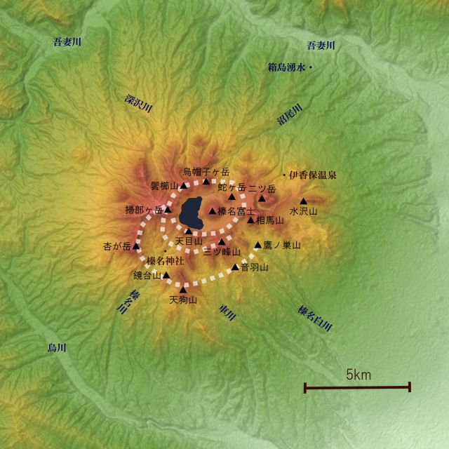
| current | 04:02, 19 August 2017 | | 640 × 640 (70 KB) | 㭍月例祭 (talk | contribs) | {{Information |Description=榛名山のカルデラ略図 |Source=c:Mount Haruna Relief Map, SRTM-1.jpgを基に作成(『なるほど榛名学』(栗原久・著、上毛新聞社、2009、p24)を参考) |Date=2017/08/19 |Location= |Au... |
You cannot overwrite this file.
File usage on Commons
There are no pages that use this file.
File usage on other wikis
The following other wikis use this file:
- Usage on ja.wikipedia.org