File:暗峠 最大斜度地点.jpg
Jump to navigation
Jump to search

Size of this preview: 800 × 600 pixels. Other resolutions: 320 × 240 pixels | 640 × 480 pixels | 1,024 × 768 pixels | 1,280 × 960 pixels | 2,400 × 1,800 pixels.
Original file (2,400 × 1,800 pixels, file size: 865 KB, MIME type: image/jpeg)
Captions
Captions
Add a one-line explanation of what this file represents
Summary
[edit]
| Description |
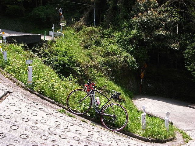
English: 37 percent slope on the way to Kuragari Pass on the National Route 308/Osaka Prefectural Road and Nara Prefectural Road Route 702 in Higashiosaka City, Osaka Prefecture, Japan
日本語: 暗峠に通じる国道308号/大阪府道・奈良県道702号上の斜度37パーセント地点。カメラの水平判定機能を使って撮影 |
| Date | |
| Source | Own work |
| Author | roubaix2009 |
Licensing
[edit]
I, the copyright holder of this work, hereby publish it under the following licenses:

|
Permission is granted to copy, distribute and/or modify this document under the terms of the GNU Free Documentation License, Version 1.2 or any later version published by the Free Software Foundation; with no Invariant Sections, no Front-Cover Texts, and no Back-Cover Texts. A copy of the license is included in the section entitled GNU Free Documentation License. |
This file is licensed under the Creative Commons Attribution-Share Alike 3.0 Unported, 2.5 Generic, 2.0 Generic and 1.0 Generic license.
- You are free:
- to share – to copy, distribute and transmit the work
- to remix – to adapt the work
- Under the following conditions:
- attribution – You must give appropriate credit, provide a link to the license, and indicate if changes were made. You may do so in any reasonable manner, but not in any way that suggests the licensor endorses you or your use.
- share alike – If you remix, transform, or build upon the material, you must distribute your contributions under the same or compatible license as the original.
You may select the license of your choice.
File history
Click on a date/time to view the file as it appeared at that time.
| Date/Time | Thumbnail | Dimensions | User | Comment | |
|---|---|---|---|---|---|
| current | 15:09, 13 May 2009 | | 2,400 × 1,800 (865 KB) | Roubaix2009 (talk | contribs) | {{Information |Description={{ja|1=暗峠道中で最大斜度と思われる地点。なお、カメラの水平判定機能を使って撮影したもの。}} |Source=投稿者撮影 |Author=roubaix2009 |Date=2009年5月2日 |Permission= |other_versions= |
You cannot overwrite this file.
File usage on Commons
There are no pages that use this file.
File usage on other wikis
The following other wikis use this file:
- Usage on az.wikipedia.org
- Usage on ja.wikipedia.org