File:地図-宮崎県宮崎郡.png
地図-宮崎県宮崎郡.png (230 × 280 pixels, file size: 4 KB, MIME type: image/png)
Captions
Captions
Summary
[edit]
| Description |
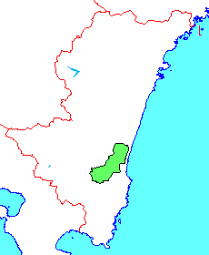
日本語: 郡区町村編成法以前の宮崎郡。1896年に北那珂郡(那珂郡を南北2郡に分けられ誕生)を編入しました。 |
||
| Source | File:Japan map.png | ||
| Author |
|
||
| Permission (Reusing this file) |
|
Licensing
[edit]

|
Permission is granted to copy, distribute and/or modify this document under the terms of the GNU Free Documentation License, Version 1.2 or any later version published by the Free Software Foundation; with no Invariant Sections, no Front-Cover Texts, and no Back-Cover Texts. A copy of the license is included in the section entitled GNU Free Documentation License. |
- You are free:
- to share – to copy, distribute and transmit the work
- to remix – to adapt the work
- Under the following conditions:
- attribution – You must give appropriate credit, provide a link to the license, and indicate if changes were made. You may do so in any reasonable manner, but not in any way that suggests the licensor endorses you or your use.
- share alike – If you remix, transform, or build upon the material, you must distribute your contributions under the same or compatible license as the original.
File history
Click on a date/time to view the file as it appeared at that time.
| Date/Time | Thumbnail | Dimensions | User | Comment | |
|---|---|---|---|---|---|
| current | 18:54, 16 February 2007 | | 230 × 280 (4 KB) | BigBang19 (talk | contribs) | 郡区町村編成法以前の宮崎郡。1896年に北那珂郡(那珂郡を南北2郡に分けられ誕生)を編入しました。 {{Japan map}} |
You cannot overwrite this file.
File usage on Commons
There are no pages that use this file.
File usage on other wikis
The following other wikis use this file:
- Usage on ja.wikipedia.org