File:南方澳第三漁港-108-sea-pa-131-re-201911082104325dc546ef2fc1a0.jpg
Jump to navigation
Jump to search

Size of this preview: 800 × 272 pixels. Other resolutions: 320 × 109 pixels | 640 × 217 pixels | 1,024 × 348 pixels | 1,280 × 435 pixels | 5,184 × 1,761 pixels.
Original file (5,184 × 1,761 pixels, file size: 3.71 MB, MIME type: image/jpeg)
Captions
Captions
Add a one-line explanation of what this file represents
Summary
[edit]
| Description |
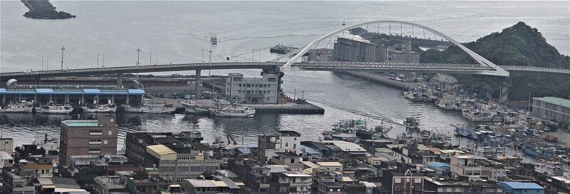
中文(臺灣):南方澳位於台灣東北部的宜蘭縣蘇澳鎮境內東南方,其三面環山,地形隱蔽且近漁場,又與其對面的島以砂洲相連成陸連島,因而造就成一道天然防波堤,為一東臨太平洋的天然漁港,除了是台灣三大漁港之一,也是東部遠洋漁業的重要基地。南方澳內共有三個漁港,第一漁港日治時期完成,第二漁港亦於1959年完工。1965年起,為了運輸需要,在南方澳漁港北側由基隆港務局投資興建小型商港,1975年蘇澳商港開始進行大規模施工,南方澳的小型商港改為工作船的泊地。1983年蘇澳商港竣工,基隆港務局在翌年將此小型商港撥交給宜蘭縣政府,成為南方澳第三漁港,為大型圍網漁船和扒網漁船以及遠洋漁船停泊港,漁獲大部分以箱來計算,屬大盤交易;另透過碼頭和港區內的重機械搬運,大量的鯖魚也都在此漁港卸貨送至加工廠做為魚罐頭。 |
| Source | https://memory.culture.tw/Home/Detail?Id=282778&IndexCode=Culture_Place |
| Author | 創作者:莊文生;鐘碧娟;謝淑娟。貢獻者:宜蘭縣政府文化局 |
| Camera location | | View this and other nearby images on: OpenStreetMap |
|---|
Licensing
[edit]
This file is licensed under the Creative Commons Attribution 3.0 Taiwan license.
- You are free:
- to share – to copy, distribute and transmit the work
- to remix – to adapt the work
- Under the following conditions:
- attribution – You must give appropriate credit, provide a link to the license, and indicate if changes were made. You may do so in any reasonable manner, but not in any way that suggests the licensor endorses you or your use.


|
This file, which was originally posted to an external website, has not yet been reviewed by an administrator or reviewer to confirm that the above license is valid. See Category:License review needed for further instructions.
|
File history
Click on a date/time to view the file as it appeared at that time.
| Date/Time | Thumbnail | Dimensions | User | Comment | |
|---|---|---|---|---|---|
| current | 07:58, 13 April 2022 | 5,184 × 1,761 (3.71 MB) | Muyueh Bot (talk | contribs) |
You cannot overwrite this file.
File usage on Commons
There are no pages that use this file.