File:仙寰橋附近的絕景.jpg
Jump to navigation
Jump to search

Size of this preview: 389 × 600 pixels. Other resolutions: 155 × 240 pixels | 311 × 480 pixels | 498 × 768 pixels | 1,167 × 1,800 pixels.
Original file (1,167 × 1,800 pixels, file size: 3.28 MB, MIME type: image/jpeg)
Captions
Captions
Add a one-line explanation of what this file represents
Summary
[edit]
| Description |
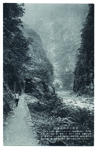
中文(臺灣):此圖為日治時期仙寰橋附近的風景樣貌,從圖中可以看見遠方的仙寰橋懸吊於兩山壁之間,看起來十分壯觀驚險。山壁間的樹林鬱鬱蔥蔥,立霧溪從下方流淌,行人則在一旁緩緩走過。仙寰橋建於1915年(大正4年),為當時進入太魯閣峽谷的第一座鐵線橋,1940年(昭和15年)7月4日,由東臺灣電力會社主導開鑿自仙寰橋至溪畔,全長共5公里之自動車道,此路段被稱之為發電道路。而由花蓮港廳理蕃課主導開鑿由溪畔至塔比多(今天祥),全長共12公里的自動車道,此路段另被稱之為產金道路。產金路段的開發使原仙寰橋與周邊的古道逐漸荒廢沒落,現仙寰橋的水泥橋面仍坐落於太魯閣國家公園的長春橋附近。此影像收錄於2016年(民國105年)由花蓮文史工作者葉柏強先生撰寫、花蓮縣文化局出版的《顧我洄瀾:花蓮歷史影像集》,書中收錄了大量花蓮在地的歷史影像,如老照片、繪葉書、宣傳摺頁、郵戳樣式等,是深入花蓮文史的重要書籍。 |
| Source | https://memory.culture.tw/Home/Detail?Id=514683&IndexCode=Culture_Object |
| Author | 創作者:花蓮縣文化局。貢獻者:花蓮縣文化局 |
Licensing
[edit]
This file is licensed under the Creative Commons Attribution 3.0 Taiwan license.
- You are free:
- to share – to copy, distribute and transmit the work
- to remix – to adapt the work
- Under the following conditions:
- attribution – You must give appropriate credit, provide a link to the license, and indicate if changes were made. You may do so in any reasonable manner, but not in any way that suggests the licensor endorses you or your use.

File history
Click on a date/time to view the file as it appeared at that time.
| Date/Time | Thumbnail | Dimensions | User | Comment | |
|---|---|---|---|---|---|
| current | 04:08, 14 April 2022 | | 1,167 × 1,800 (3.28 MB) | Muyueh Bot (talk | contribs) |
You cannot overwrite this file.
File usage on Commons
There are no pages that use this file.