File:お鉢平と北鎮岳 - panoramio.jpg
Jump to navigation
Jump to search

Size of this preview: 800 × 600 pixels. Other resolutions: 320 × 240 pixels | 640 × 480 pixels | 1,024 × 768 pixels | 1,280 × 960 pixels | 2,048 × 1,536 pixels.
Original file (2,048 × 1,536 pixels, file size: 1.32 MB, MIME type: image/jpeg)
Captions
Captions
Add a one-line explanation of what this file represents
Summary
[edit]
| Description |
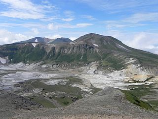
日本語: お鉢平カルデラと北鎮岳(右)。北海岳から北西を撮影。左奥は安足間岳や比布岳。
English: Ohachidaira Caldera and Mount Hokuchin (right). Looking northwest. Taken from Mount Hokkai. |
||
| Date | Taken on 28 August 2010 | ||
| Source | https://web.archive.org/web/20161017233933/http://www.panoramio.com/photo/40011863 | ||
| Author | pakku | ||
| Permission (Reusing this file) |
This file is licensed under the Creative Commons Attribution 3.0 Unported license. Attribution: pakku
|
| Camera location | | View this and other nearby images on: OpenStreetMap |
|---|
File history
Click on a date/time to view the file as it appeared at that time.
| Date/Time | Thumbnail | Dimensions | User | Comment | |
|---|---|---|---|---|---|
| current | 14:01, 7 November 2016 | | 2,048 × 1,536 (1.32 MB) | Panoramio upload bot (talk | contribs) | {{Information |description=お鉢平と北鎮岳 |date={{Taken on|2010-08-28}} |source=http://www.panoramio.com/photo/40011863 |author=[http://www.panoramio.com/user/1029415?with_photo_id=40011863 pakku] |permission={{cc-by-3.0|pakku}} {{Panoramiorevie... |
You cannot overwrite this file.
File usage on Commons
There are no pages that use this file.