File:ولايات سورية العثمانية حتى 1917.png
Jump to navigation
Jump to search

Size of this preview: 231 × 599 pixels. Other resolutions: 92 × 240 pixels | 331 × 859 pixels.
Original file (331 × 859 pixels, file size: 415 KB, MIME type: image/png)
Captions
Captions
Add a one-line explanation of what this file represents
Summary
[edit]| Description |
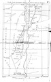
العربية: التقسيم الإداري العثماني لجنوب غرب سورية من عام 1856 حتى عام 1900.
English: Ottoman administrative division of south west Syria from 1856 till 1900. |
| Date | (translated version), original: early 20th century. |
| Source | Own work (translated version), original: ottoman palestine |
| Author | Bassem (translated version), original: Unknown. |
| Permission (Reusing this file) |
|


Licensing
[edit]
|
This work is in the public domain in its country of origin and other countries and areas where the copyright term is the author's life plus 70 years or fewer. | |
| This file has been identified as being free of known restrictions under copyright law, including all related and neighboring rights. | |
File history
Click on a date/time to view the file as it appeared at that time.
| Date/Time | Thumbnail | Dimensions | User | Comment | |
|---|---|---|---|---|---|
| current | 21:12, 23 July 2012 | 331 × 859 (415 KB) | باسم (talk | contribs) | removed empty space | |
| 21:00, 23 July 2012 |  | 411 × 860 (375 KB) | باسم (talk | contribs) |
You cannot overwrite this file.
File usage on Commons
The following 6 pages use this file:
- File:McMahon letter 'districts'.png
- File:Mount Lebanon, Ottoman Syria 1914.png
- File:Ottoman levant.png
- File:Peel-Commission Report Map1 AdminDistrictsSyriaPalestine 1154x1846.png
- File:Pre-war Turkish Administrative Districts comprised in Syria and Palestine of Peel Commission Report 1937.tif
- File:ولايات سورية العثمانية حتى 1917.jpg.png (file redirect)
File usage on other wikis
The following other wikis use this file:
- Usage on ar.wikipedia.org
- جنين (مدينة)
- الحسين بن علي شريف مكة
- بلعا
- بورين (نابلس)
- بديا
- دير بلوط
- كفل حارس
- بيتللو
- سنجق نابلس
- ولاية بيروت
- سنجق عكا
- سنجق طرابلس الشام
- سنجق اللاذقية
- سنجق حماة
- سنجق دمشق
- سنجق حوران
- سنجق معان
- بوابة:الشام/مقالة مختارة/6
- ويكيبيديا:جائزة المنتج - النصف الثاني لعام 2012/باسم
- سنجق بيروت
- بوابة:الشام/مسار/1
- بوابة:الشام/مسار/2
- احتلال معان