File:الدولة العباسية.jpg
Jump to navigation
Jump to search

Size of this preview: 800 × 501 pixels. Other resolutions: 320 × 201 pixels | 640 × 401 pixels | 1,024 × 642 pixels | 1,428 × 895 pixels.
Original file (1,428 × 895 pixels, file size: 493 KB, MIME type: image/jpeg)
Captions
Captions
Add a one-line explanation of what this file represents
Summary
[edit]
| Description |
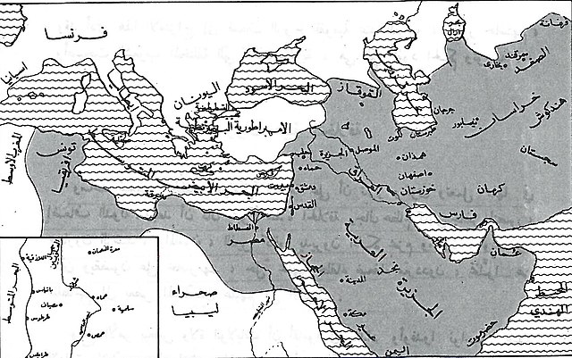
العربية: خارطة الدولة العبَّاسيَّة بعد انفصال المغرب والأندلُس عنها وقبل تفكُكها إلى دُويلات وإمارات مُستقلَّة إداريًّا.
English: Map of the Abbasid Caliphate after the Maghreb and Al-Andalus separated from it and prior to its fragmentation in to several emirates and states. |
| Date | |
| Source | Taken from a book entitled "المُصوَّر في التاريخ" first published in Lebanon in 1962, Dar Al-'ilm lilmalayeen (دار العلم للميلايين). |
| Author | Unknown author |
Licensing
[edit]
This work was first published in Lebanon and is now in the public domain because its copyright protection has expired by virtue of the Law No. 75 of 1999 on the Protection of Literary and Artistic Property (details). However attribution of the author is still required. The work meets one of the following criteria:
|
 |
File history
Click on a date/time to view the file as it appeared at that time.
| Date/Time | Thumbnail | Dimensions | User | Comment | |
|---|---|---|---|---|---|
| current | 19:17, 6 July 2016 | | 1,428 × 895 (493 KB) | باسم (talk | contribs) | User created page with UploadWizard |
You cannot overwrite this file.
File usage on Commons
The following page uses this file:
File usage on other wikis
The following other wikis use this file:
- Usage on ar.wikipedia.org