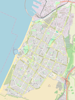
File:מפת רובעי אשדוד – תוכנית אסטרטגית 2040 להסעת המונים ולתחבורה ציבורית בנפת אשקלון.svg

Original file (SVG file, nominally 1,060 × 1,405 pixels, file size: 8.1 MB)
Captions
Captions
Summary
[edit]| Descriptionמפת רובעי אשדוד – תוכנית אסטרטגית 2040 להסעת המונים ולתחבורה ציבורית בנפת אשקלון.svg |
עברית: מפת הקווים המתוכננים לעבור בעיר אשדוד במסגרת התוכנית האסטרטגית להסעת המונים ולתחבורה ציבורית בנפת אשקלון (2040)
English: Map of the transit lines planned in Ashdod as part of the Ashkelon District Public Transportation and Mass Transit Strategic Plan 2040 |
|||
| Date | (see file history) | |||
| Source | You may find a page on the OpenStreetMap wiki page for Planned lines of MATAAN 2040 of the Ashkelon District, Ashdod | |||
| Creator |
OpenStreetMap contributors OpenStreetMap contributors |
|||
| Permission (Reusing this file) |
OpenStreetMap data is available under the Open Database License (details). Map tiles are licensed under the Creative Commons Attribution-ShareAlike 2.0 license (CC-BY-SA 2.0).
This file is licensed under the Creative Commons Attribution-Share Alike 2.0 Generic license.
|
|||
| Georeferencing | Georeference the map in Wikimaps Warper If inappropriate please set warp_status = skip to hide. |
This file was derived from: Quarters of Ashdod map (Detailed).svg: 
  Contributed or improved as part of the Ashdod Portal on the Hebrew Wikipedia נתרם או שופר במסגרת פורטל אשדוד בוויקיפדיה העברית English: Ashdod Portal is a voluntary portal established in the Hebrew Wikipedia in 2023 with the aim of improving, expanding and deepening knowledge about the city of Ashdod online. As part of the portal, many photos, information in Wikipedia entries and important archival documents about the city were added and cataloged. עברית: פורטל אשדוד הוא פורטל התנדבותי שהוקם בוויקיפדיה העברית ב-2023 במטרה לשפר, להרחיב ולהעמיק את הידע על העיר אשדוד ברשת. במסגרת הפורטל, נוספו וקוטלגו תמונות רבות, מידעים בערכי ויקיפדיה ומסמכים ארכיוניים חשובים על העיר. To view all images uploaded as part of the portal • לצפייה בכל התמונות שהועלו במסגרת הפורטל |
File history
Click on a date/time to view the file as it appeared at that time.
| Date/Time | Thumbnail | Dimensions | User | Comment | |
|---|---|---|---|---|---|
| current | 15:43, 12 June 2024 |  | 1,060 × 1,405 (8.1 MB) | מקף־עברי (talk | contribs) | magenta line -> red line, new intersection points and overall improvement |
| 15:19, 12 June 2024 |  | 1,060 × 1,405 (8.1 MB) | מקף־עברי (talk | contribs) | slight fix, added line intersection points in the north and south | |
| 14:34, 12 June 2024 |  | 1,060 × 1,405 (8.1 MB) | מקף־עברי (talk | contribs) | Uploaded own work with UploadWizard |
You cannot overwrite this file.
File usage on Commons
The following 2 pages use this file:
File usage on other wikis
The following other wikis use this file:
- Usage on he.wikipedia.org
- Usage on www.wikidata.org
Metadata
This file contains additional information such as Exif metadata which may have been added by the digital camera, scanner, or software program used to create or digitize it. If the file has been modified from its original state, some details such as the timestamp may not fully reflect those of the original file. The timestamp is only as accurate as the clock in the camera, and it may be completely wrong.
| Width | 795pt |
|---|---|
| Height | 1054pt |
