File:מפלון בבניאס העילי.jpg
Original file (4,000 × 6,016 pixels, file size: 8.81 MB, MIME type: image/jpeg)
Captions
Summary
[edit]Descriptionמפלון בבניאס העילי.jpg |
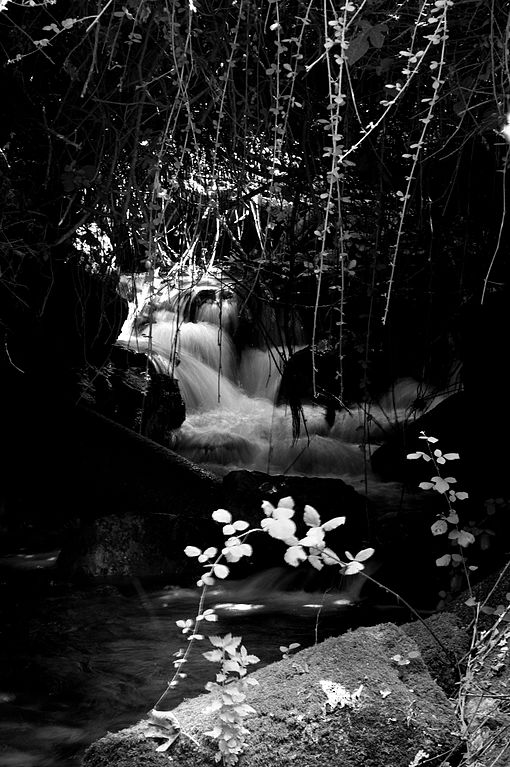
עברית: נַחַל חֶרְמוֹן (מכונה גם בָּנְיַאס, הגייה ערבית של השם הקדום פָנְיַאס - העיצור p אינו פונמה בשפה הערבית ולכן נעשה שימוש בעיצור b), הוא נחל איתן והוא המזרחי במקורות הירדן. כמות מימיו היא כרבע מכלל מי נהר הירדן.
|
||
Date | |||
Source | Own work | ||
Author | אהוד הלפרין |
Camera location | 33° 14′ 48″ N, 35° 41′ 34″ E | View this and other nearby images on: OpenStreetMap | 33.246667; 35.692778 |
---|
כוון המצלמה משוער בלבד
Licensing
[edit]- You are free:
- to share – to copy, distribute and transmit the work
- to remix – to adapt the work
- Under the following conditions:
- attribution – You must give appropriate credit, provide a link to the license, and indicate if changes were made. You may do so in any reasonable manner, but not in any way that suggests the licensor endorses you or your use.
- share alike – If you remix, transform, or build upon the material, you must distribute your contributions under the same or compatible license as the original.
This image was uploaded as part of Wiki Loves Monuments 2016.
Afrikaans ∙ Alemannisch ∙ العربية ∙ جازايرية ∙ azərbaycanca ∙ Bikol Central ∙ беларуская ∙ беларуская (тарашкевіца) ∙ български ∙ বাংলা ∙ brezhoneg ∙ bosanski ∙ català ∙ čeština ∙ Cymraeg ∙ dansk ∙ Deutsch ∙ Zazaki ∙ Ελληνικά ∙ English ∙ Esperanto ∙ español ∙ eesti ∙ euskara ∙ فارسی ∙ suomi ∙ français ∙ Frysk ∙ Gaeilge ∙ galego ∙ עברית ∙ हिन्दी ∙ hrvatski ∙ magyar ∙ հայերեն ∙ Bahasa Indonesia ∙ Ido ∙ italiano ∙ 日本語 ∙ ქართული ∙ 한국어 ∙ кыргызча ∙ Lëtzebuergesch ∙ latviešu ∙ Malagasy ∙ македонски ∙ മലയാളം ∙ Bahasa Melayu ∙ Malti ∙ norsk bokmål ∙ नेपाली ∙ Nederlands ∙ norsk nynorsk ∙ norsk ∙ polski ∙ português ∙ português do Brasil ∙ română ∙ русский ∙ sicilianu ∙ davvisámegiella ∙ slovenčina ∙ slovenščina ∙ shqip ∙ српски / srpski ∙ svenska ∙ ไทย ∙ Tagalog ∙ Türkçe ∙ українська ∙ اردو ∙ oʻzbekcha / ўзбекча ∙ Yorùbá ∙ 中文 ∙ 中文(中国大陆) ∙ 中文(简体) ∙ 中文(繁體) ∙ 中文(香港) ∙ 中文(臺灣) ∙ +/− |
File history
Click on a date/time to view the file as it appeared at that time.
Date/Time | Thumbnail | Dimensions | User | Comment | |
---|---|---|---|---|---|
current | 04:06, 27 October 2016 | 4,000 × 6,016 (8.81 MB) | אהוד הלפרין (talk | contribs) | User created page with UploadWizard |
You cannot overwrite this file.
File usage on Commons
The following page uses this file:
Metadata
This file contains additional information such as Exif metadata which may have been added by the digital camera, scanner, or software program used to create or digitize it. If the file has been modified from its original state, some details such as the timestamp may not fully reflect those of the original file. The timestamp is only as accurate as the clock in the camera, and it may be completely wrong.
Camera manufacturer | RICOH IMAGING COMPANY, LTD. |
---|---|
Camera model | PENTAX K-3 |
Copyright holder | HALPERIN*EHUD |
Exposure time | 1/4 sec (0.25) |
F-number | f/0 |
ISO speed rating | 100 |
Date and time of data generation | 11:14, 3 September 2016 |
Lens focal length | 75 mm |
Orientation | Rotated 90° CCW |
Horizontal resolution | 300 dpi |
Vertical resolution | 300 dpi |
Software used | PENTAX K-3 Ver. 1.00 |
File change date and time | 11:14, 3 September 2016 |
Y and C positioning | Co-sited |
Exposure Program | Aperture priority |
Exif version | 2.3 |
Date and time of digitizing | 11:14, 3 September 2016 |
Meaning of each component |
|
APEX exposure bias | 0 |
Metering mode | Center weighted average |
Flash | Flash did not fire, compulsory flash suppression |
Supported Flashpix version | 1 |
Color space | sRGB |
Sensing method | One-chip color area sensor |
File source | Digital still camera |
Scene type | A directly photographed image |
Custom image processing | Custom process |
Exposure mode | Auto exposure |
White balance | Auto white balance |
Focal length in 35 mm film | 112 mm |
Scene capture type | Standard |
Contrast | Hard |
Saturation | Normal |
Sharpness | Hard |
Subject distance range | Unknown |
GPS tag version | 0.0.3.2 |
Structured data
33°14'48.001"N, 35°41'34.001"E
3 September 2016
image/jpeg
9,242,977 byte
6,016 pixel
4,000 pixel
8ca5b344bd38e79567ec8a544053e959d75b7df3
0.25 second
100
75 millimetre
- Heritage sites in Israel with known IDs
- Heritage sites in Israel missing SDC location of creation
- Files with coordinates missing SDC location of creation
- CC-BY-SA-4.0
- Self-published work
- Images from Wiki Loves Monuments 2016
- Images from Wiki Loves Monuments 2016 in Israel
- Images from Wiki Loves Monuments missing SDC location of creation
- Uploaded via Campaign:wlm-il
- Israel photographs taken on 2016-09-03