File:מעלה העקרבים - זאב שטיים.jpg
Original file (1,500 × 2,000 pixels, file size: 3.91 MB, MIME type: image/jpeg)
Captions
Summary
[edit]Descriptionמעלה העקרבים - זאב שטיים.jpg |
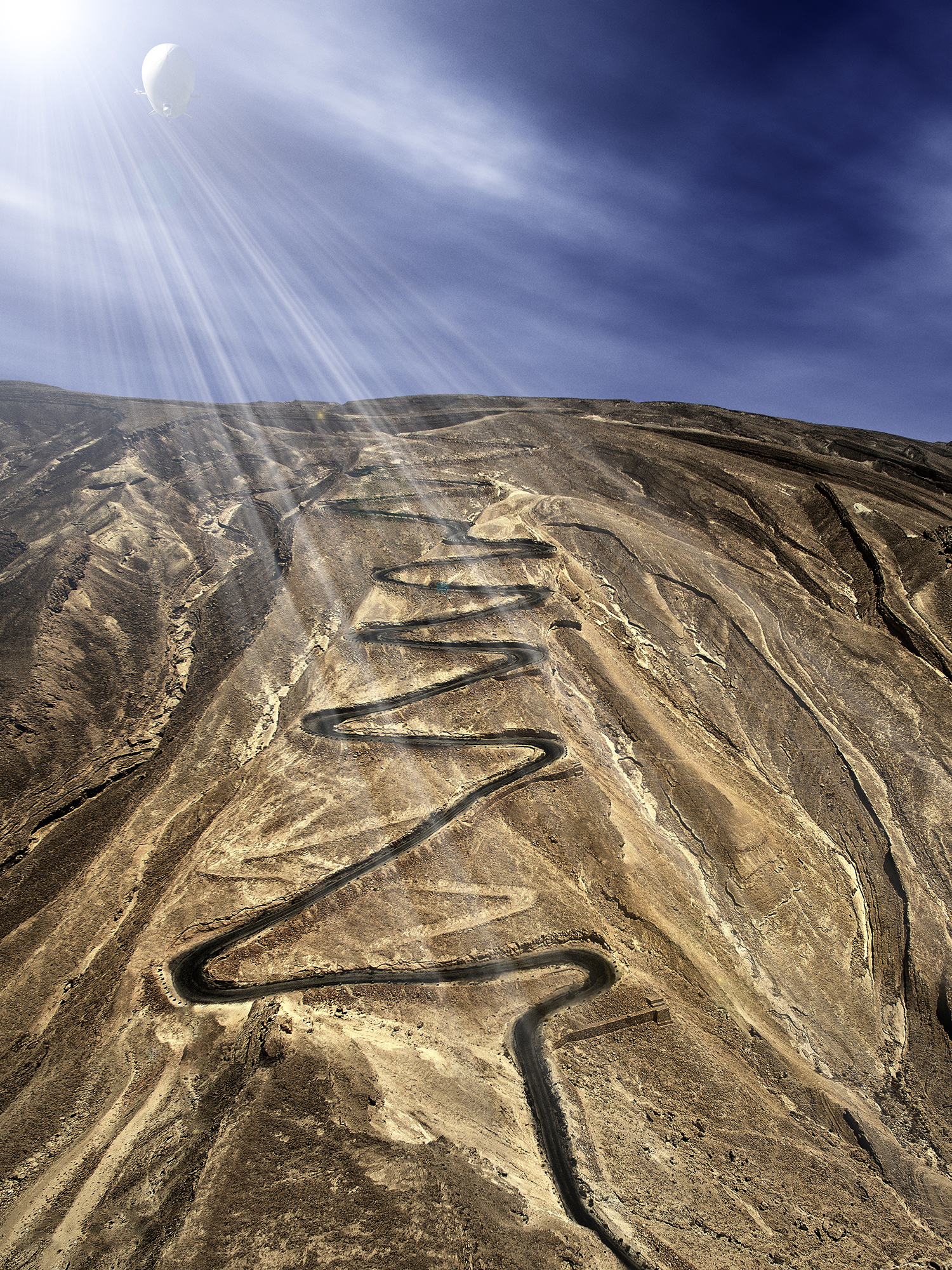
עברית: דרך תלולה ומפותלת בנגב המזרחי, מדרום למכתש הקטן, בקטע המרכזי של כביש 227. המעלה שימש עורק תחבורה עיקרי בין באר שבע לאילת מאז סלילת הכביש במקום ב-1927 ועד 1956, אז נסלל כביש מעלה העצמאות (כביש 40). בראש המעלה ניצבת אנדרטה בצורת צריח (סמל חיל ההנדסה הישראלי) שהוקמה לזכר הנופלים במבצע לוט ב-1950. מעל לאנדרטה, בראש המצפה, נמצא לוח זיכרון לזכר הנרצחים בטבח מעלה עקרבים שאירע ב-17 במרץ 1954.
|
||
Date | |||
Source | Own work | ||
Author | ZeevStein |
Camera location | 30° 54′ 11.32″ N, 35° 07′ 49.91″ E | View this and other nearby images on: OpenStreetMap | 30.903145; 35.130530 |
---|
Licensing
[edit]- You are free:
- to share – to copy, distribute and transmit the work
- to remix – to adapt the work
- Under the following conditions:
- attribution – You must give appropriate credit, provide a link to the license, and indicate if changes were made. You may do so in any reasonable manner, but not in any way that suggests the licensor endorses you or your use.
- share alike – If you remix, transform, or build upon the material, you must distribute your contributions under the same or compatible license as the original.
This image was uploaded as part of Wiki Loves Monuments 2016.
Afrikaans ∙ Alemannisch ∙ العربية ∙ جازايرية ∙ azərbaycanca ∙ Bikol Central ∙ беларуская ∙ беларуская (тарашкевіца) ∙ български ∙ বাংলা ∙ brezhoneg ∙ bosanski ∙ català ∙ čeština ∙ Cymraeg ∙ dansk ∙ Deutsch ∙ Zazaki ∙ Ελληνικά ∙ English ∙ Esperanto ∙ español ∙ eesti ∙ euskara ∙ فارسی ∙ suomi ∙ français ∙ Frysk ∙ Gaeilge ∙ galego ∙ עברית ∙ हिन्दी ∙ hrvatski ∙ magyar ∙ հայերեն ∙ Bahasa Indonesia ∙ Ido ∙ italiano ∙ 日本語 ∙ ქართული ∙ 한국어 ∙ кыргызча ∙ Lëtzebuergesch ∙ latviešu ∙ Malagasy ∙ македонски ∙ മലയാളം ∙ Bahasa Melayu ∙ Malti ∙ norsk bokmål ∙ नेपाली ∙ Nederlands ∙ norsk nynorsk ∙ norsk ∙ polski ∙ português ∙ português do Brasil ∙ română ∙ русский ∙ sicilianu ∙ davvisámegiella ∙ slovenčina ∙ slovenščina ∙ shqip ∙ српски / srpski ∙ svenska ∙ ไทย ∙ Tagalog ∙ Türkçe ∙ українська ∙ اردو ∙ Yorùbá ∙ 中文 ∙ 中文(中国大陆) ∙ 中文(简体) ∙ 中文(繁體) ∙ 中文(香港) ∙ 中文(臺灣) ∙ +/− |
File history
Click on a date/time to view the file as it appeared at that time.
Date/Time | Thumbnail | Dimensions | User | Comment | |
---|---|---|---|---|---|
current | 06:09, 22 November 2016 | 1,500 × 2,000 (3.91 MB) | Ynhockey (talk | contribs) | Uploading version without the caption | |
18:43, 14 October 2016 | 1,500 × 2,000 (3.92 MB) | ZeevStein (talk | contribs) | User created page with UploadWizard |
You cannot overwrite this file.
File usage on Commons
The following 2 pages use this file:
File usage on other wikis
The following other wikis use this file:
- Usage on de.wikivoyage.org
- Usage on fi.wiktionary.org
- Usage on he.wikipedia.org
Metadata
This file contains additional information such as Exif metadata which may have been added by the digital camera, scanner, or software program used to create or digitize it. If the file has been modified from its original state, some details such as the timestamp may not fully reflect those of the original file. The timestamp is only as accurate as the clock in the camera, and it may be completely wrong.
Camera manufacturer | DJI |
---|---|
Camera model | FC300X |
Author | Zeev Stein |
Copyright holder |
|
Exposure time | 1/130 sec (0.0076923076923077) |
F-number | f/2.8 |
ISO speed rating | 100 |
Date and time of data generation | 10:52, 25 June 2016 |
Lens focal length | 3.61 mm |
Latitude | 30° 54′ 11.32″ N |
Longitude | 35° 7′ 49.91″ E |
Altitude | 326.627 meters above sea level |
Label | Red |
Width | 2,822 px |
Height | 3,763 px |
Bits per component |
|
Pixel composition | RGB |
Orientation | Normal |
Number of components | 3 |
Horizontal resolution | 200 dpi |
Vertical resolution | 200 dpi |
Software used | Adobe Photoshop CS6 (Windows) |
File change date and time | 22:19, 1 November 2016 |
Exposure Program | 58655 |
Exif version | 2.3 |
Date and time of digitizing | 10:52, 25 June 2016 |
APEX shutter speed | 7.022368 |
APEX aperture | 2.970854 |
APEX exposure bias | 0.34375 |
Maximum land aperture | 2 APEX (f/2) |
Subject distance | 0 meters |
Metering mode | Spot |
Light source | Unknown |
Flash | Flash did not fire, No flash function |
Color space | Uncalibrated |
File source | Digital still camera |
Scene type | A directly photographed image |
Custom image processing | Normal process |
Exposure mode | Auto exposure |
White balance | Auto white balance |
Digital zoom ratio | 0 |
Focal length in 35 mm film | 20 mm |
Scene capture type | Standard |
Scene control | None |
Contrast | Normal |
Saturation | Normal |
Sharpness | Normal |
Subject distance range | Unknown |
GPS tag version | 0.0.3.2 |
Serial number of camera | 2014031100 |
Lens used | 20.7 mm |
Rating (out of 5) | 0 |
Date metadata was last modified | 00:19, 2 November 2016 |
Unique ID of original document | 1A0E132EB1C19845E3CF55B123B1068B |
Copyright status | Copyrighted |
Contact information | zeev13552@gmail.com
www.zeevstein.com
|
IIM version | 2,972 |