File:ארץ ישראל Erez Israel (FL197701839 1100165).jpg
Jump to navigation
Jump to search

Size of this preview: 421 × 599 pixels. Other resolutions: 168 × 240 pixels | 337 × 480 pixels | 539 × 768 pixels | 719 × 1,024 pixels | 1,438 × 2,048 pixels | 11,122 × 15,834 pixels.
Original file (11,122 × 15,834 pixels, file size: 242.21 MB, MIME type: image/jpeg)
Captions
Captions
Add a one-line explanation of what this file represents
Summary
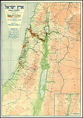
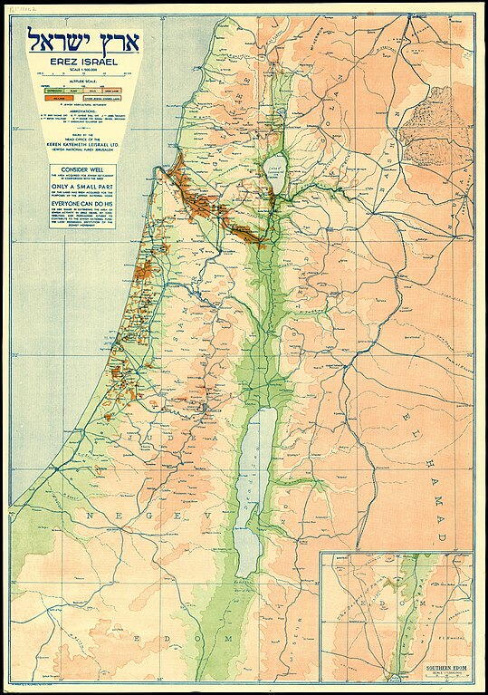
[edit]| ארץ ישראל Erez Israel
( |
||||||||||||||||||||||||
|---|---|---|---|---|---|---|---|---|---|---|---|---|---|---|---|---|---|---|---|---|---|---|---|---|
| Title |
ארץ ישראל Erez Israel |
|||||||||||||||||||||||
| Publisher |
Head Office of the Keren Kayemeth Leisrael |
|||||||||||||||||||||||
| Description |
ארץ ישראל Erez Israel.. |
|||||||||||||||||||||||
| Language | English | |||||||||||||||||||||||
| Publication date | 1934 | |||||||||||||||||||||||
| Medium | 1 sheet : color ; | |||||||||||||||||||||||
| Dimensions | height: 66 cm (25.9 in); width: 46 cm (18.1 in) | |||||||||||||||||||||||
| Collection |
|
|||||||||||||||||||||||
| Current location |
|
|||||||||||||||||||||||
| Place of publication | Jerusalem | |||||||||||||||||||||||
| search Merhav catalog | Jerusalem | |||||||||||||||||||||||
| Notes | See also Hebrew edition Pal 1361, English edition Pal 1361.1, German edition Pal 1361.3.; Inset: Southern Edom, scale 1:1,000,000 | |||||||||||||||||||||||
| scale | 1:500,000 cm | |||||||||||||||||||||||
| IE PID | IE197701837 | |||||||||||||||||||||||
| Rosetta filename | FL197701839 | |||||||||||||||||||||||
| NNL item ID (P3959) | 997011001656405171 | |||||||||||||||||||||||
| search Merhav catalog | English | |||||||||||||||||||||||
| search Merhav catalog | Erez Israelארץ ישראלLand tenureEretz IsraelMapsHead Office of the Keren Kayemeth Leisrael | |||||||||||||||||||||||
| Source/Photographer |
|
|||||||||||||||||||||||
| Other versions | ||||||||||||||||||||||||
| Jpg / Tif version |
|
|||||||||||||||||||||||

.jpg)

.jpg&action=edit§ion=1)
Licensing
[edit].jpg&action=edit§ion=2)
This UK artistic or literary work, of which the author is unknown and cannot be ascertained by reasonable enquiry, is in the public domain because it is one of the following:
|
 |
File history
Click on a date/time to view the file as it appeared at that time.
| Date/Time | Thumbnail | Dimensions | User | Comment | |
|---|---|---|---|---|---|
| current | 16:33, 2 September 2023 | | 11,122 × 15,834 (242.21 MB) | Geagea (talk | contribs) | pattypan 22.03 |
You cannot overwrite this file.
File usage on Commons
The following page uses this file:
.jpg&oldid=797858174)