File:Явище «цвітіння води» на прикладі Каховського водосховища.jpg
Jump to navigation
Jump to search

Size of this preview: 800 × 545 pixels. Other resolutions: 320 × 218 pixels | 640 × 436 pixels | 1,024 × 697 pixels | 1,280 × 871 pixels | 2,560 × 1,742 pixels | 3,263 × 2,221 pixels.
Original file (3,263 × 2,221 pixels, file size: 1.89 MB, MIME type: image/jpeg)
Captions
Captions
Add a one-line explanation of what this file represents
Summary
[edit]
| Description |
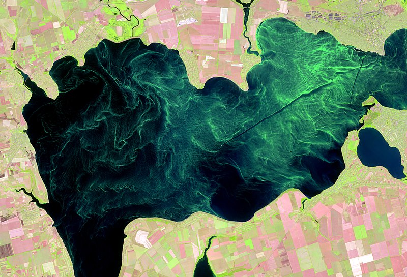
Українська: Зображення явища «цвітіння води» на прикладі Каховського водосховища отримане 10 серпня 2016 року супутником Sentinel-2, надане Європейським космічним агентством в межах проекту Copernicus. Знімок синтезований у «штучних кольорах», де кольорам зображення поставлені у відповідність наступні спектральні канали супутникового зображення із різних частин електромагнітного спектру: 1 – SWIR Band (1610 нм), 2 - NIR Band (842 нм), 3 – Red Band (665 нм).
«Цвітінням» води називають масовий розвиток мікроскопічних водоростей, що супроводжуються значним погіршенням якості води. Це викликано цілим комплексом факторів, таких як зміна клімату, надходження в воду великої кількості різних мінеральних і органічних речовин та пов'язане з інтенсифікацією господарської діяльності людини. Інтенсивне цвітіння, характерно, перш за все, для водойм зі слабкими течіями зокрема таких, як каскад Дніпровських водосховищ. Космічний знімок показує, що області інтенсивного цвітіння витягуються уздовж течій і втягуються до вихрових рухів, окрім цього на перенесення водоростей найзначніший вплив має вітер. У періоди з тривалою теплою, сонячною і безвітряної погодою ціанобактерії об'єднуються в агрегати, які спливають до поверхні, утворюючи поверхневі або підповерхневі скупчення. На супутникових зображеннях ціанобактерії проявляються у вигляді яскравих ниткоподібних смуг (філаментів) або цілих скупчень. Причому колір цих плям залежить від стадії розвитку водоростей: від яскраво-зелених до буро-коричневих.
English: The satellite image of the phenomenon of "algae bloom" at the Kakhovka reservoir territory, was received on August 10, 2016 by the Sentinel-2 satellite provided by the European Space Agency within the Copernicus project. The сomposite is created in "artificial colors" where the following channels of the satellite image from different parts of the electromagnetic spectrum are matched to the image colors: 1 - SWIR Band (1610 nm), 2 - NIR Band (842 nm), 3 - Red Band (665 nm).
"Algae bloom" of water is the mass growth of microscopic algae, accompanied by significant deterioration of water quality. This is caused by the set of factors, such as climate change, a large number of different mineral and organic substances falling into water and is associated with the intensification of human economic activity. Intensive "algae bloom" is characteristic, above all, for reservoirs with weak currents in particular such as the cascade of the Dnipro reservoirs. The space image shows that the intensive bloom areas are stretched along currents and are involved in vortex movements, in addition to the transfer of algae, the most significant influence is the wind. In periods with prolonged warm, sunny and windless weather, cyanobacteria are combined into aggregates that forming surface or subsurface clusters. On satellite images, the cyanobacteria appear in the form of bright filamentous stripes or even clusters. And the color of these spots depends on the stage of development of algae: from bright green to brownish brown own. |
| Date | |
| Source | Own work |
| Author | Tomchenko Olha |
| Camera location | | View this and other nearby images on: OpenStreetMap |
|---|
Licensing
[edit]
I, the copyright holder of this work, hereby publish it under the following license:
This file is licensed under the Creative Commons Attribution 4.0 International license.
- You are free:
- to share – to copy, distribute and transmit the work
- to remix – to adapt the work
- Under the following conditions:
- attribution – You must give appropriate credit, provide a link to the license, and indicate if changes were made. You may do so in any reasonable manner, but not in any way that suggests the licensor endorses you or your use.
| This image was uploaded as part of Wiki Science Competition 2017. |
File history
Click on a date/time to view the file as it appeared at that time.
| Date/Time | Thumbnail | Dimensions | User | Comment | |
|---|---|---|---|---|---|
| current | 11:45, 30 November 2017 | | 3,263 × 2,221 (1.89 MB) | Tomch olha (talk | contribs) | User created page with UploadWizard |
You cannot overwrite this file.
File usage on Commons
The following 8 pages use this file:
- User:Kruusamägi/Teadusfoto2
- Commons:Wiki Science Competition 2017/Winners
- Commons:Wiki Science Competition 2017/Winners/General category
- Commons:Wiki Science Competition 2017/Winners/General category/round 2
- Commons:Wiki Science Competition 2017/Winners/Ukraine
- Commons:Wiki Science Competition 2017 in Ukraine/Winners
- Category:General category images from Russian Science Photo Competition 2020
- Category:Wiki Science Competition 2020 in Russia
File usage on other wikis
The following other wikis use this file:
- Usage on et.wikipedia.org
- Usage on ru.wikimedia.org
- Конкурсы/Конкурс научных фотографий 2019/tt
- Конкурсы/Конкурс научных фотографий 2019/en
- Конкурсы/Конкурс научных фотографий 2020
- Конкурсы/Конкурс научных фотографий 2020/tt
- Конкурсы/Конкурс научных фотографий 2020/en
- Конкурсы/Конкурс научных фотографий 2021/en
- Конкурсы/Конкурс научных фотографий 2021/tt
- Usage on sr.wikipedia.org
- Usage on uk.wikipedia.org