File:Рельеф Намибии.png
Jump to navigation
Jump to search

Size of this preview: 630 × 600 pixels. Other resolutions: 252 × 240 pixels | 504 × 480 pixels | 806 × 768 pixels | 1,075 × 1,024 pixels | 1,995 × 1,900 pixels.
Original file (1,995 × 1,900 pixels, file size: 3.57 MB, MIME type: image/png)
Captions
Captions
Add a one-line explanation of what this file represents
Summary
[edit]
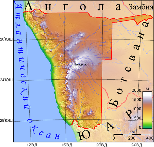
| Description | рельеф Намибии |
| Date | 5 August 2008 (original upload date) |
| Source |
This file was derived from: Namibia Topography.png: |
| Author |
|
| This is a retouched picture, which means that it has been digitally altered from its original version. The original can be viewed here: Namibia Topography.png:
|

|
Permission is granted to copy, distribute and/or modify this document under the terms of the GNU Free Documentation License, Version 1.2 or any later version published by the Free Software Foundation; with no Invariant Sections, no Front-Cover Texts, and no Back-Cover Texts. A copy of the license is included in the section entitled GNU Free Documentation License. |
This file is licensed under the Creative Commons Attribution-Share Alike 3.0 Unported license.
- You are free:
- to share – to copy, distribute and transmit the work
- to remix – to adapt the work
- Under the following conditions:
- attribution – You must give appropriate credit, provide a link to the license, and indicate if changes were made. You may do so in any reasonable manner, but not in any way that suggests the licensor endorses you or your use.
- share alike – If you remix, transform, or build upon the material, you must distribute your contributions under the same or compatible license as the original.
Original upload log
[edit]
This image is a derivative work of the following images:
- File:Namibia Topography.png licensed with PD-self
- 2007-06-29T20:41:11Z Sadalmelik 2094x1934 (3015184 Bytes) Better data, better colours
- 2007-06-21T21:51:26Z Sadalmelik 2094x1934 (3025565 Bytes) {{Information |Description=Topographic map of Namibia. Created with GMT from public domain GLOBE data, |Source=self-made |Date=June 21, 2007 |Author= [[User:Sadalmelik|Sadalmelik]] }} [[Category:Maps of Namibia]] [[Category:
Transferred from ru.wikipedia to Commons using For the Common Good.
The original description page was here. All following user names refer to ru.wikipedia.
| Date/Time | Dimensions | User | Comment |
|---|---|---|---|
| 11:33, 5 August 2008 | 1,995 × 1,900 (3,747,576 bytes) | w:ru:Savinsasha (talk | contribs) | {{Изображение | Описание = рельеф Намибии | Автор = Sadalmelik (русский вариант: Савин А. С.) | Время создания = 5.08.2008 | Источник = http://en.wikipedia |
File history
Click on a date/time to view the file as it appeared at that time.
| Date/Time | Thumbnail | Dimensions | User | Comment | |
|---|---|---|---|---|---|
| current | 20:55, 17 April 2017 | | 1,995 × 1,900 (3.57 MB) | Joeroeq (talk | contribs) | Transferred from ru.wikipedia: see original upload log above |
You cannot overwrite this file.
File usage on Commons
There are no pages that use this file.
File usage on other wikis
The following other wikis use this file:
- Usage on ba.wikipedia.org
- Usage on be.wikipedia.org
- Usage on cv.wikipedia.org
- Usage on ru.wikipedia.org
- Usage on ru.wikimedia.org