File:Околиці Замкової гори в селі Куземин 14.jpg
Jump to navigation
Jump to search
Size of this preview: 799 × 208 pixels. Other resolutions: 320 × 83 pixels | 640 × 167 pixels | 1,024 × 267 pixels | 1,280 × 333 pixels | 6,880 × 1,792 pixels.
Original file (6,880 × 1,792 pixels, file size: 2.77 MB, MIME type: image/jpeg)
Captions
Captions
Add a one-line explanation of what this file represents
Summary
[edit]
| Description |
Українська: «Гетьманський», Великописарівський р-н: Дмитрівська, Попівська, Вільненська, Ямненська, Добрянська, Солдатська, Рябинівська, Катанська, Кирилівська с/р, Великописарівська сел./р; ДП «Охтирський лісгосп»: Великописарівське л-во, кв. 31-45, 52-66. ДП «Тростянецький лісгосп»: Литовське л-во, кв. 25-27. ДП «Великописарівський агролісгосп». Охтирський р-н: Бакирівська, Староіванівська, Пологівська, Кардашівська, Чернеччинська, Хухрянська, Лутищанська, В'язівська, Куземинська с/р; ДП «Охтирський лісгосп»: Охтирське л-во, кв. 1-42, 76-77; Хухрянське л-во, кв. 22, 27-28, 38-40, 51-60, 78, 84-85, 88-92, 97-98. ДП «Тростянецький лісгосп»: Литовське л-во, кв. 69. ДП «Охтирський агролісгосп»: кв. 28 (вид. 1-8, 13-21), 50 (вид. 1-6), 30 (вид. 1-12, 14-19), 31 (вид. 1, 5-9, 23), 92 (вид. 1-9, 18-19), 95 (вид. 1-13, 15, 17-20), 77 (вид. 14, 18-31), 78 (вид. 6-11, 13), 79 (вид. 1-17). Тростянецький р-н: Кам'янська, Зарічненська, Мащанська с/р, Тростянецька м/р; ДП «Тростянецький лісгосп»: Тростянецьке л-во, кв. 1-6, 13, 19-25; 27, 30, 33, 35-45, 78-79. ДП «Тростянецький агролісгосп»: кв. 95 (вид. 29-32, 36, 48, 50, 56), 104 (вид. 1-15), 105 (вид. 4)
|
| Date | |
| Source | Own work |
| Author | Angkorbat |
| Camera location | | View this and other nearby images on: OpenStreetMap |
|---|
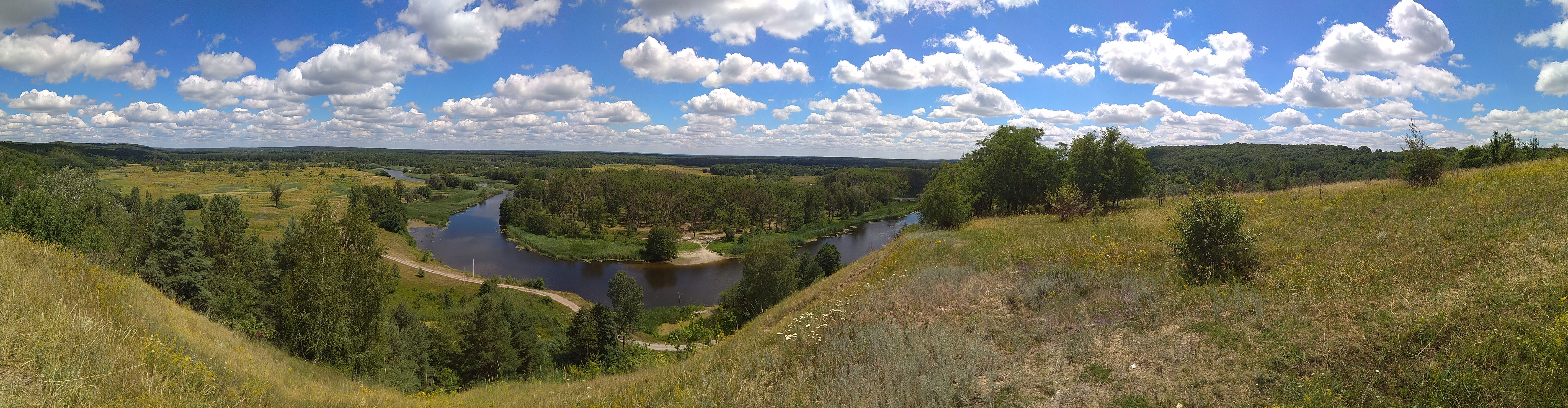
Панорама річки Ворскли біля села Куземин, Охтирського району, Сумської області. Вид із Замкової гори.
Licensing
[edit]
I, the copyright holder of this work, hereby publish it under the following license:
This file is licensed under the Creative Commons Attribution-Share Alike 4.0 International license.
- You are free:
- to share – to copy, distribute and transmit the work
- to remix – to adapt the work
- Under the following conditions:
- attribution – You must give appropriate credit, provide a link to the license, and indicate if changes were made. You may do so in any reasonable manner, but not in any way that suggests the licensor endorses you or your use.
- share alike – If you remix, transform, or build upon the material, you must distribute your contributions under the same or compatible license as the original.
This image was uploaded as part of Wiki Loves Earth 2020.
|
 |
File history
Click on a date/time to view the file as it appeared at that time.
| Date/Time | Thumbnail | Dimensions | User | Comment | |
|---|---|---|---|---|---|
| current | 18:18, 20 July 2020 | 6,880 × 1,792 (2.77 MB) | Angkorbat (talk | contribs) | Uploaded own work with UploadWizard |
You cannot overwrite this file.
File usage on Commons
The following page uses this file:
File usage on other wikis
The following other wikis use this file:
- Usage on uk.wikipedia.org