File:Новобіла 13.jpg

Original file (4,000 × 6,000 pixels, file size: 13.87 MB, MIME type: image/jpeg)
Captions
Captions
Summary
[edit]
| Description |
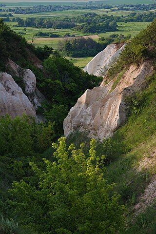
Українська: Новобіла, Новопсковський район, Луганська область.
Оголошена рішенням Луганської обласної ради № 8/7 від 29 вересня 1999 р. Місце розташування: Новопсковський район, поміж сc. Новобіла, Павленкове та Литвинове. Площа — 2407,1 га. Крейдова та петрофітно-степова рослинність на крейдових відслоненнях правого берега р. Білої, що включає велику кількість рідкісних, зникаючих, ендемічних видів рослин. В цих місцях можна побачити цікаві геологічні форми. Це вимиті водою за сотні років глибокі яри і химерні фігури з крейди і крейдянистого грунту. В цих ярах і на крутих схилах ростуть чудові рослини - квіти, трави, кущі, дерева. Про ці місця можна сказати словами поета: " Квітучий яр, а не сумне провалля!"English: Novobila, Novopskovsky district, Luhansk region.
Announced by the decision of the Luhansk Regional Council № 8/7 of September 29, 1999. Location: Novopskovsky district, between p. Novobile, Pavlenkove and Lytvynove. Area - 2407.1 hectares. Cretaceous and petrophytic-steppe vegetation on the Cretaceous outcrops of the right bank of the Bila River, which includes a large number of rare, endangered, endemic plant species. In these places you can see interesting geological forms. These are deep ravines and bizarre figures of chalk and chalky soil washed by water for hundreds of years. In these ravines and on steep slopes grow beautiful plants - flowers, grasses, shrubs, trees.These places can be said in the words of the poet: "Blooming ravine, not a sad abyss!"
|
||
| Date | |||
| Source | Own work | ||
| Author | Aisheyko |
| Camera location | | View this and other nearby images on: OpenStreetMap |
|---|
Licensing
[edit]
- You are free:
- to share – to copy, distribute and transmit the work
- to remix – to adapt the work
- Under the following conditions:
- attribution – You must give appropriate credit, provide a link to the license, and indicate if changes were made. You may do so in any reasonable manner, but not in any way that suggests the licensor endorses you or your use.
- share alike – If you remix, transform, or build upon the material, you must distribute your contributions under the same or compatible license as the original.
This image was uploaded as part of Wiki Loves Earth 2021.
|
 |
File history
Click on a date/time to view the file as it appeared at that time.
| Date/Time | Thumbnail | Dimensions | User | Comment | |
|---|---|---|---|---|---|
| current | 07:23, 27 June 2021 | | 4,000 × 6,000 (13.87 MB) | Aisheyko (talk | contribs) | Uploaded own work with UploadWizard |
You cannot overwrite this file.
File usage on Commons
The following page uses this file: