File:Адміністративний будинок з висоти.jpg
![File:Адміністративний будинок з висоти.jpg](https://upload.wikimedia.org/wikipedia/commons/thumb/a/a4/%D0%90%D0%B4%D0%BC%D1%96%D0%BD%D1%96%D1%81%D1%82%D1%80%D0%B0%D1%82%D0%B8%D0%B2%D0%BD%D0%B8%D0%B9_%D0%B1%D1%83%D0%B4%D0%B8%D0%BD%D0%BE%D0%BA_%D0%B7_%D0%B2%D0%B8%D1%81%D0%BE%D1%82%D0%B8.jpg/800px-%D0%90%D0%B4%D0%BC%D1%96%D0%BD%D1%96%D1%81%D1%82%D1%80%D0%B0%D1%82%D0%B8%D0%B2%D0%BD%D0%B8%D0%B9_%D0%B1%D1%83%D0%B4%D0%B8%D0%BD%D0%BE%D0%BA_%D0%B7_%D0%B2%D0%B8%D1%81%D0%BE%D1%82%D0%B8.jpg?20190929150547)
Original file (3,876 × 2,725 pixels, file size: 6.57 MB, MIME type: image/jpeg)
Captions
Captions
Summary
[edit]DescriptionАдміністративний будинок з висоти.jpg |
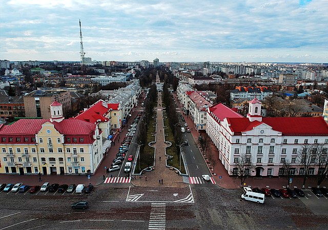
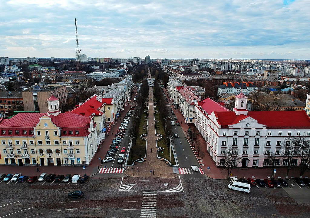
Українська: Адміністративний будинок, Чернігів, вул. Гетьмана Полуботка, 2
|
||
Date | |||
Source | Own work | ||
Author | Andrew Matus |
Camera location | 51° 29′ 27″ N, 31° 17′ 55″ E ![]() | View this and other nearby images on: OpenStreetMap | ![]() |
---|
Licensing
[edit]![w:en:Creative Commons](https://upload.wikimedia.org/wikipedia/commons/thumb/7/79/CC_some_rights_reserved.svg/90px-CC_some_rights_reserved.svg.png)
![attribution](https://upload.wikimedia.org/wikipedia/commons/thumb/1/11/Cc-by_new_white.svg/24px-Cc-by_new_white.svg.png)
![share alike](https://upload.wikimedia.org/wikipedia/commons/thumb/d/df/Cc-sa_white.svg/24px-Cc-sa_white.svg.png)
- You are free:
- to share – to copy, distribute and transmit the work
- to remix – to adapt the work
- Under the following conditions:
- attribution – You must give appropriate credit, provide a link to the license, and indicate if changes were made. You may do so in any reasonable manner, but not in any way that suggests the licensor endorses you or your use.
- share alike – If you remix, transform, or build upon the material, you must distribute your contributions under the same or compatible license as the original.
![]() |
This image was uploaded as part of Wiki Loves Monuments 2019.
Afrikaans ∙ Alemannisch ∙ azərbaycanca ∙ Bahasa Indonesia ∙ Bahasa Melayu ∙ Bikol Central ∙ bosanski ∙ brezhoneg ∙ català ∙ čeština ∙ Cymraeg ∙ dansk ∙ davvisámegiella ∙ Deutsch ∙ eesti ∙ English ∙ español ∙ Esperanto ∙ euskara ∙ français ∙ Frysk ∙ Gaeilge ∙ galego ∙ hrvatski ∙ Ido ∙ italiano ∙ latviešu ∙ Lëtzebuergesch ∙ Malagasy ∙ magyar ∙ Malti ∙ Nederlands ∙ norsk ∙ norsk nynorsk ∙ norsk bokmål ∙ polski ∙ português ∙ português do Brasil ∙ română ∙ shqip ∙ sicilianu ∙ slovenčina ∙ slovenščina ∙ suomi ∙ svenska ∙ Tagalog ∙ Türkçe ∙ Yorùbá ∙ Zazaki ∙ Ελληνικά ∙ беларуская ∙ беларуская (тарашкевіца) ∙ български ∙ кыргызча ∙ македонски ∙ русский ∙ српски / srpski ∙ українська ∙ ქართული ∙ հայերեն ∙ नेपाली ∙ हिन्दी ∙ বাংলা ∙ മലയാളം ∙ ไทย ∙ 한국어 ∙ +/− |
![]() |
File history
Click on a date/time to view the file as it appeared at that time.
Date/Time | Thumbnail | Dimensions | User | Comment | |
---|---|---|---|---|---|
current | 15:05, 29 September 2019 | ![]() | 3,876 × 2,725 (6.57 MB) | Andrew Matus (talk | contribs) | User created page with UploadWizard |
You cannot overwrite this file.
File usage on Commons
The following page uses this file:
File usage on other wikis
The following other wikis use this file:
- Usage on ru.wikipedia.org
- Usage on uk.wikipedia.org
Metadata
This file contains additional information such as Exif metadata which may have been added by the digital camera, scanner, or software program used to create or digitize it. If the file has been modified from its original state, some details such as the timestamp may not fully reflect those of the original file. The timestamp is only as accurate as the clock in the camera, and it may be completely wrong.
Copyright holder | ????????? ????? 2019. ??? ????? ????????. |
---|---|
Image title | Processed with VSCO with s3 preset |
Camera manufacturer | DJI |
Camera model | FC1102 |
ISO speed rating | 100 |
F-number | f/2.6 |
Exposure time | 1/640 sec (0.0015625) |
Lens focal length | 4.49 mm |
User comments | d with VSCO with s3 preset |
Date and time of data generation | 15:49, 20 March 2019 |
Latitude | 51° 29′ 27″ N |
Longitude | 31° 17′ 55″ E |
Altitude | 37.8 meters above sea level |
Software used | VSCO Android Version: v103 (2537) |
Orientation | Normal |
File change date and time | 13:19, 30 March 2019 |
Y and C positioning | Centered |
Horizontal resolution | 72 dpi |
Vertical resolution | 72 dpi |
Exposure Program | Normal program |
Subject distance range | Unknown |
Sharpness | Normal |
Flash | Flash did not fire |
Saturation | Normal |
Light source | Unknown |
Contrast | Normal |
Metering mode | Average |
Scene control | None |
Scene capture type | Standard |
Focal length in 35 mm film | 25 mm |
Maximum land aperture | 2.757 APEX (f/2.6) |
Date and time of digitizing | 15:49, 20 March 2019 |
APEX exposure bias | 0 |
Digital zoom ratio | 0 |
White balance | Auto white balance |
Exposure mode | Auto exposure |
Image compression mode | 3.5352131568678 |
APEX aperture | 2.757 |
Meaning of each component |
|
Color space | sRGB |
Scene type | A directly photographed image |
Custom image processing | Normal process |
APEX shutter speed | 640 |
Exif version | 2.3 |
Supported Flashpix version | 1 |
File source | Digital still camera |
GPS tag version | 0.0.2.3 |
Structured data
Items portrayed in this file
depicts
51°29'26.999"N, 31°17'55.000"E
20 March 2019
0.0015625 second
2.6
4.49 millimetre
100
image/jpeg
- Cultural heritage monuments in Ukraine with known IDs
- Cultural heritage monuments in Ukraine missing SDC depicts
- Cultural heritage monuments in Ukraine missing SDC location of creation
- Files with coordinates missing SDC location of creation
- CC-BY-SA-4.0
- Self-published work
- Images from Wiki Loves Monuments 2019
- Images from Wiki Loves Monuments 2019 in Ukraine
- Images from Wiki Loves Monuments missing SDC depicts
- Images from Wiki Loves Monuments missing SDC location of creation
- Wiki loves monuments in Ukraine 2019 - Quality
- Uploaded via Campaign:wlm-ua
- Ukraine photographs taken on 2019-03-20