File:Η Κωνσταντινούπολη κατά τη βυζαντινή περίοδο.svg
Jump to navigation
Jump to search

Size of this PNG preview of this SVG file: 662 × 600 pixels. Other resolutions: 265 × 240 pixels | 530 × 480 pixels | 848 × 768 pixels | 1,130 × 1,024 pixels | 2,261 × 2,048 pixels | 2,085 × 1,889 pixels.
Original file (SVG file, nominally 2,085 × 1,889 pixels, file size: 483 KB)
Captions
Captions
Add a one-line explanation of what this file represents
 This media file has been nominated for deletion since 8 September 2024. To discuss it, please visit the nomination page.
Do not remove this tag until the deletion nomination is closed. Reason for the nomination: Needless duplicate (also uploaded at a later date than the original) of File:Byzantine Constantinople-el.svg.
| |||
| |||
Summary
[edit]
| Description |
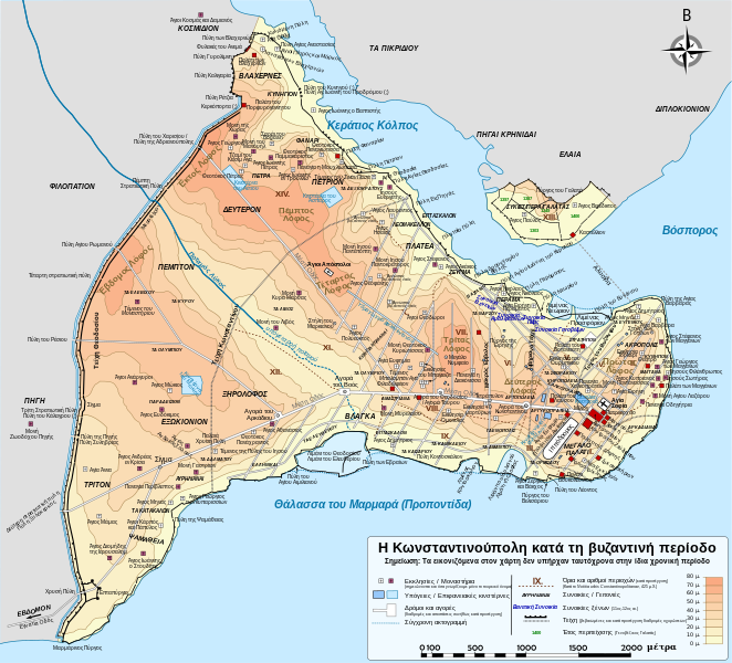
Ελληνικά: Τοπογραφικός χάρτης Κωνσταντινουπόλεως κατά τη Βυζαντινή περίοδο. Βασική πηγή χάρτη: R. Janin, Constantinople Byzantine. Developpement urbain et repertoire topographique. Το οδικό δίκτυο και διάφορες άλλες λεπτομέρειες με βάση το Dumbarton Oaks Papers 54. Πληροφορίες για τις εκκλησίες, ιδιαίτερα τις μη ταυτοποιημένες, από την ιστοσελίδα The Byzantine Churches of Istanbul του Πανεπιστημίου της Νέας Υόρκης.
Καταβλήθηκε κάθε δυνατή προσπάθειας για να είναι ο χάρτης αυτός πλήρης και ακριβής, ωστόσο ενδεχομένως να υπάρχουν λάθη και παραλείψεις. Κάθε διόρθωση ή υπόδειξη είναι ευπρόσδεκτη. Ο χάρτης δεν εμφανίζεται σωστά την παρούσα ιστοσελίδα, καθώς το σύστημα δεν "διαβάζει" όλες τις γραμματοσειρές από το αρχείο svg. Ωστόσο, μπορείτε να δείτε κανονικά τον χάρτη κάνοντας κλικ επάνω σε αυτόν, κάτι που τον ανοίγει σε μεγέθυνση, όπως και αν τον κατεβάσετε στον υπολογιστή σας και τον ανοίξετε με μια εφαρμογή επεξεργασίας αρχείων svg. |
| Date | |
| Source | File:Byzantine_Constantinople.svg |
| Author | Cplakidas |
Licensing
[edit]
This file is licensed under the Creative Commons Attribution-Share Alike 3.0 Unported license.
- You are free:
- to share – to copy, distribute and transmit the work
- to remix – to adapt the work
- Under the following conditions:
- attribution – You must give appropriate credit, provide a link to the license, and indicate if changes were made. You may do so in any reasonable manner, but not in any way that suggests the licensor endorses you or your use.
- share alike – If you remix, transform, or build upon the material, you must distribute your contributions under the same or compatible license as the original.
File history
Click on a date/time to view the file as it appeared at that time.
| Date/Time | Thumbnail | Dimensions | User | Comment | |
|---|---|---|---|---|---|
| current | 12:59, 3 March 2015 | | 2,085 × 1,889 (483 KB) | Kiolalis (talk | contribs) | User created page with UploadWizard |
You cannot overwrite this file.
File usage on Commons
There are no pages that use this file.