File:Železniční trať 320.png
Jump to navigation
Jump to search

Size of this preview: 800 × 468 pixels. Other resolutions: 320 × 187 pixels | 640 × 374 pixels | 1,024 × 599 pixels | 1,280 × 748 pixels | 2,560 × 1,496 pixels | 4,600 × 2,689 pixels.
Original file (4,600 × 2,689 pixels, file size: 845 KB, MIME type: image/png)
Captions
Captions
Add a one-line explanation of what this file represents
| Description |
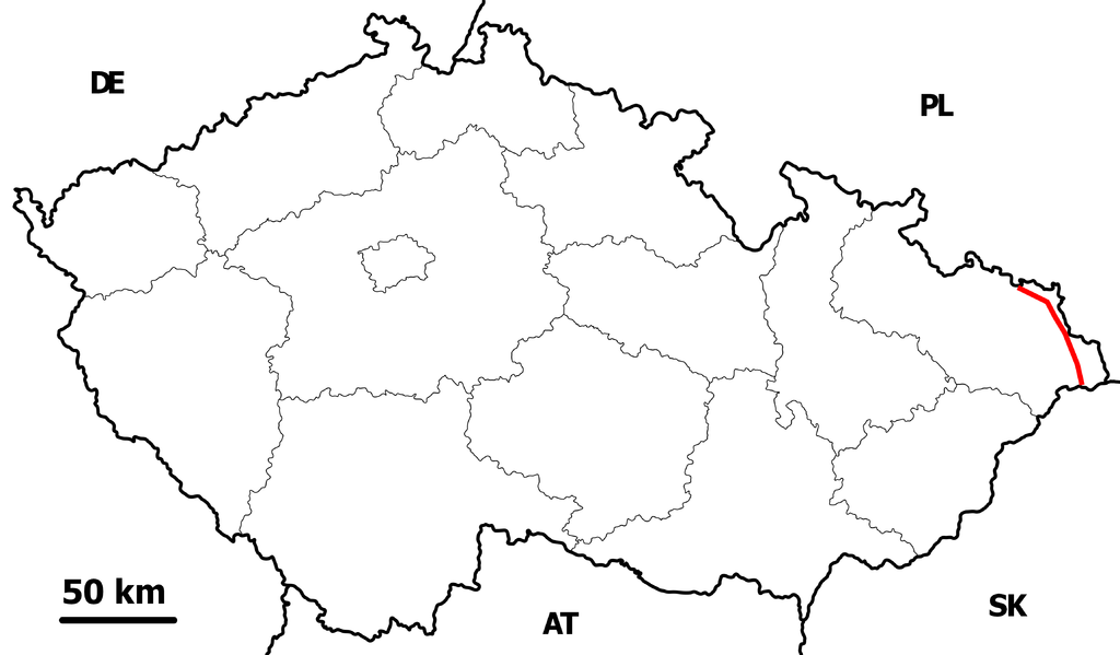
Čeština: Mapa třetího železničního koridoru v České republice English: Map of third train coridor in the Czech republic
Outline map of the Czech Republic, ready for the Geobox template, calibrated at en:Template:Geobox locator Czechia |
| Date | (UTC) |
| Source | |
| Author |
|
| This is a retouched picture, which means that it has been digitally altered from its original version. Modifications: I made a map of railroad nr 320 in Czech Republic. The original can be viewed here: Czechia - outline map.svg:
|
This file is licensed under the Creative Commons Attribution-Share Alike 3.0 Unported license.
- You are free:
- to share – to copy, distribute and transmit the work
- to remix – to adapt the work
- Under the following conditions:
- attribution – You must give appropriate credit, provide a link to the license, and indicate if changes were made. You may do so in any reasonable manner, but not in any way that suggests the licensor endorses you or your use.
- share alike – If you remix, transform, or build upon the material, you must distribute your contributions under the same or compatible license as the original.
Original upload log
[edit]
This image is a derivative work of the following images:
- File:Treti_zeleznicni_koridor.svg licensed with Cc-by-3.0, GFDL
- 2008-09-14T18:33:36Z Jagro 3000x1717 (324805 Bytes) {{Information |Description={{cs|Mapa třetího železničního koridoru v České republice}} {{en|Map of third train coridor in the Czech republic}} |Source=Vlastní fotografie/ Own work |Date=14. 8. 2008 |Author=Honza Groh
- File:Czechia_-_outline_map.svg licensed with Cc-by-sa-3.0,2.5,2.0,1.0, GFDL
- 2007-09-03T22:11:49Z Caroig 5342x3123 (129950 Bytes) {{Information |Description=Outline map of the Czech Republic, ready for the [[:en:Template:Geobox|Geobox]] template |Source=self-made |Date=2007-08-07 |Author= [[:en:User:Caroig|Caroig]] |Permission= }} [[Category:Geobox ma
Uploaded with derivativeFX
File history
Click on a date/time to view the file as it appeared at that time.
| Date/Time | Thumbnail | Dimensions | User | Comment | |
|---|---|---|---|---|---|
| current | 07:22, 25 July 2010 | | 4,600 × 2,689 (845 KB) | Olos88 (talk | contribs) | {{Information |Description={{cs|Mapa třetího železničního koridoru v České republice}} {{en|Map of third train coridor in the Czech republic}} Outline map of the Czech Republic, ready for the Geobox template, calibrated at [ |
You cannot overwrite this file.
File usage on Commons
The following page uses this file:
File usage on other wikis
The following other wikis use this file:
- Usage on pl.wikipedia.org
- Usage on www.wikidata.org