File:Železné hory, CZ180304-23.jpg
Jump to navigation
Jump to search

Size of this preview: 800 × 442 pixels. Other resolutions: 320 × 177 pixels | 640 × 354 pixels | 1,024 × 566 pixels | 1,280 × 708 pixels | 2,560 × 1,415 pixels | 4,817 × 2,663 pixels.
Original file (4,817 × 2,663 pixels, file size: 2.68 MB, MIME type: image/jpeg)
Captions
Captions
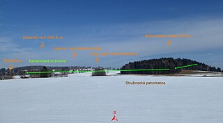
Under Zuberský hill (650.5 m) in the Iron Mountains (situational interface of geomorphological units).
Summary
[edit]
| Description |
English: Protected landscape area Iron Mountains. On the photo on the left "Zuberský" hill (650.5 m), beneath it lies a hamlet (roofs of houses in the northern part), on the right is "Bačkovskýho" hill (620 m) with a wooded peak. "Možděnice" is a hamlet and the name of the cadastral territory with an area of 564.66 ha with a range of approximately 542-620 m above sea level in the landscape of Iron Mountains, within the administratives is part the village of "Vysočina" in the Chrudim district belonging to the Pardubice Region in the territory of the Czech Republic. The village buildings lies in the range 560-582 m above sea level on the southern slope of "Zuberský" hill (peak 650.5 m above sea level in the cadastral area "Trhová Kamenice"), along the nameless stream (the basin of the "Dlouhý" brook). One source of the stream originates in a nature reserve "Zubří", north of the hamlet, the second one springs northeast of the hamlet, on damp meadows on the slope of "Bačkovskýho" hill (620 m). The wooded peak is the highest point of the cadastral area "Možděnice" (range 542-620 m above sea level). On the photo are of Czech descriptions of localities and boundary of geomorphological units. Photo location: Czechia, Pardubice Region, municipality Vysočina, the hamlet of "Možděnice", "Stružinecká" knoll hill.
Čeština: Chráněná krajinná oblast Železné hory. Na fotografii vlevo Zuberský vrch (650,5 m), pod ním Možděnice (střechy domů v severní části), vpravo je Bačkovskýho kopec (620 m) se zalesněným vrcholem. Možděnice je sídelní lokalita typu vesnice a název katastrálního území o rozloze 564,66 ha s rozsahem poloh přibližně 542–620 m n. m. v krajinné oblasti Železných hor, v rámci administrativně správním část obce Vysočina v okrese Chrudim náležejícím do Pardubického kraje na území České republiky. Vesnická zástavba leží v rozsahu 560–582 m n. m. na jižním úbočí Zuberského vrchu (vrchol 650,5 m na katastrálním území Trhová Kamenice), podél bezejmenné vodoteče v povodí Dlouhého potoka. Jedna ze zdrojnic Dlouhého potoku pramení v přírodní rezervaci Zubří, severně nad vsí, druhá severovýchodně od zástavby, na vlhkých loukách ve svahu Bačkovskýho kopce (620 m). Zalesněný vrchol (trigonometrický bod č. 1, TL 2425) je nejvyšším bodem katastrálního území Možděnice (rozsah 542–620 m n. m.). Vrchol leží na rozhraní geomorfologických okrsků, Kameničská vrchovina (Zuberský vrch, Zubří) a Stružinecká pahorkatina (jižní svahy Bačkovskýho kopce, Možděnice). Na fotografii popisky lokalit a hranice geomorfologických okrsků Sečské vrchoviny v Železných horách. Foto lokace: Česko, Pardubický kraj, obec Vysočina, vesnice Možděnice, Stružinecká pahorkatina (0°). |
| Date | |
| Source | Own work |
| Author | Josef Kreuz (PEPan) |
| Camera location | | View this and other nearby images on: OpenStreetMap |
|---|
Zdroje informací:
[edit]
- AOPK ČR, přírodní poměry – mapové aplikace, viz
- ČÚZK, základní mapa Česka – kompozice Možděnice až Zubří, viz
- Mapy.cz, turistická mapa – Možděnice až Zubří, viz
Licensing
[edit]
I, the copyright holder of this work, hereby publish it under the following license:
This file is licensed under the Creative Commons Attribution-Share Alike 4.0 International license.
- You are free:
- to share – to copy, distribute and transmit the work
- to remix – to adapt the work
- Under the following conditions:
- attribution – You must give appropriate credit, provide a link to the license, and indicate if changes were made. You may do so in any reasonable manner, but not in any way that suggests the licensor endorses you or your use.
- share alike – If you remix, transform, or build upon the material, you must distribute your contributions under the same or compatible license as the original.
File history
Click on a date/time to view the file as it appeared at that time.
| Date/Time | Thumbnail | Dimensions | User | Comment | |
|---|---|---|---|---|---|
| current | 11:39, 1 May 2018 | | 4,817 × 2,663 (2.68 MB) | PEPan (talk | contribs) | User created page with UploadWizard |
You cannot overwrite this file.
File usage on Commons
There are no pages that use this file.
File usage on other wikis
The following other wikis use this file:
- Usage on cs.wikipedia.org