File:Žďárské vrchy, CZ170702-070.jpg
Original file (4,759 × 2,494 pixels, file size: 3.53 MB, MIME type: image/jpeg)
Captions
Summary
[edit]DescriptionŽďárské vrchy, CZ170702-070.jpg |
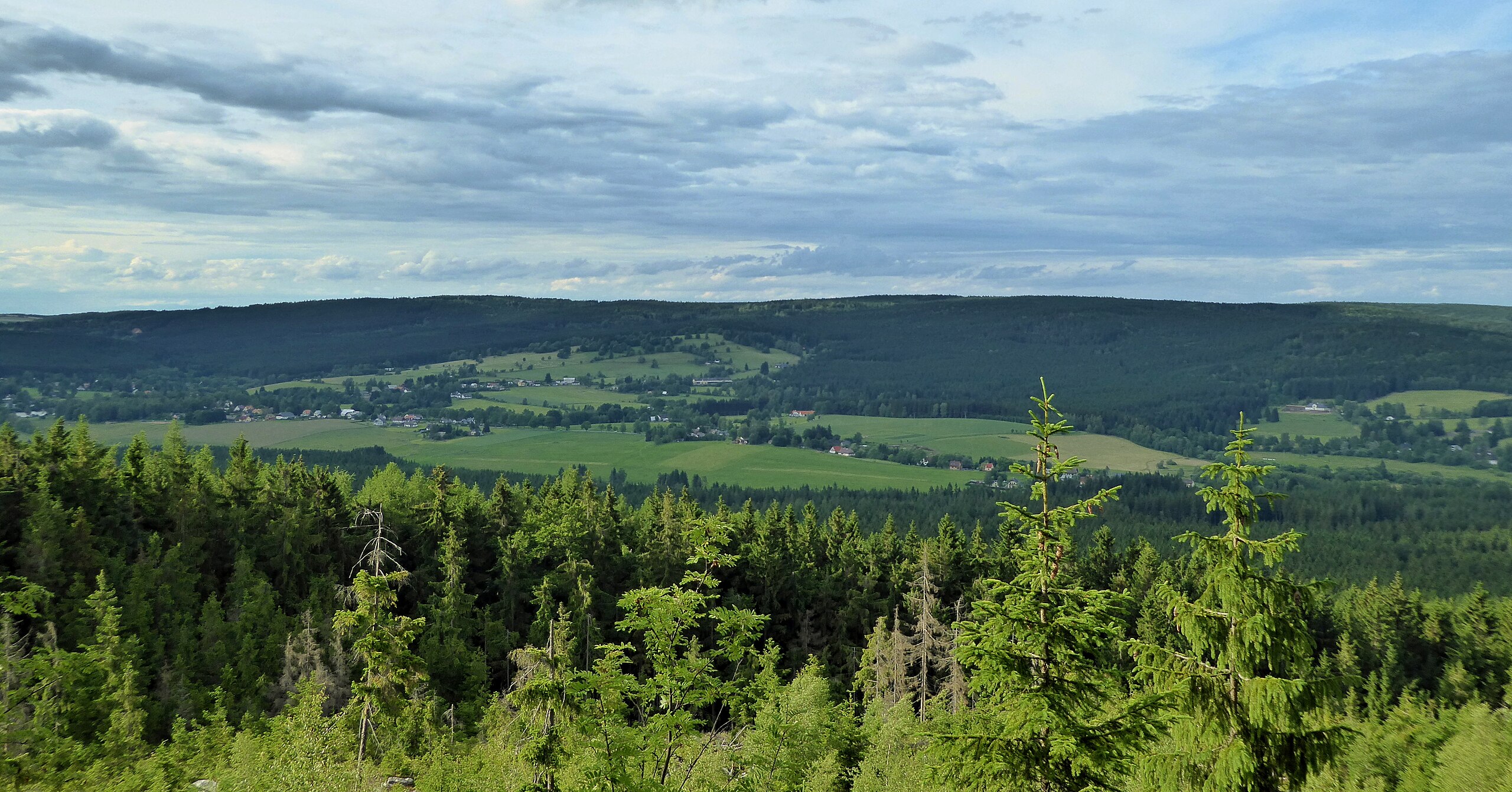
English: "Borovský" forest (forest massif on the horizon) is a landscape area and a geomorphological district in the northern part of "Žďárské" Hills. It is part of the "Hornosvratecká" Highlands in regional breakdown shape of the earth's surface of Czechia. View from the top of the Malinska Rock (811 m above sea level) in "Devítiskalská" Highlands. Photo location: Czechia, Vysočina Region, villages Křižánky.
Čeština: Borovský les (lesní masiv na obzoru) je krajinná oblast (horopisná jednotka) a geomorfologický okrsek v severní části Žďárských vrchů. Je součástí Hornosvratecké vrchoviny v regionálním členění tvaru zemského povrchu (georeliéfu) Česka. Pohled z vrcholu Malinské skály (811 m n. m.) v Devítiskalské vrchovině. Foto lokace: Česko, Kraj Vysočina, obec Křižánky. |
Date | |
Source | Own work |
Author | Josef Kreuz (PEPan) |
Camera location | 49° 39′ 41.89″ N, 16° 04′ 18.82″ E | View this and other nearby images on: OpenStreetMap | 49.661636; 16.071894 |
---|
Faktografie
[edit]Lesní masiv horopisně nejvyššího hřbetu geomorfologického okrsku Borovský les, výrazný od jihozápadu nad Milovskou kotlinou v pohledu z Malinské skály v Devítiskalské vrchovině. Geomorfologický útvar zaobleného hřbetu se táhne od vrcholu Otava ve Svratouchu (zcela vlevo) jihovýchodním směrem k vrchům Čtyřpaličatých skal v katastru České Milovy. Široké údolí s obcí Křižánky tvoří sníženina geomorfologického okrsku Milovská kotlina.
Resumé
[edit]Borovský les; krajinná oblast v rozsahu poloh 470 až 783 m n. m. a geomorfologický okrsek o rozloze 114,39 km2 v severní části Žďárských vrchů, součást Hornosvratecké vrchoviny v regionálním členění georeliéfu (tvaru zemského povrchu) Česka. Typem georeliéfu plochá vrchovina, název odvozen od polesí „Borovský les“ nad obcí Borová.
Externí odkazy
[edit]- Svratouch – České Milovy, základní mapa České republiky
Licensing
[edit]- You are free:
- to share – to copy, distribute and transmit the work
- to remix – to adapt the work
- Under the following conditions:
- attribution – You must give appropriate credit, provide a link to the license, and indicate if changes were made. You may do so in any reasonable manner, but not in any way that suggests the licensor endorses you or your use.
- share alike – If you remix, transform, or build upon the material, you must distribute your contributions under the same or compatible license as the original.
File history
Click on a date/time to view the file as it appeared at that time.
Date/Time | Thumbnail | Dimensions | User | Comment | |
---|---|---|---|---|---|
current | 11:45, 2 July 2017 | 4,759 × 2,494 (3.53 MB) | PEPan (talk | contribs) | User created page with UploadWizard |
You cannot overwrite this file.
File usage on Commons
The following page uses this file:
File usage on other wikis
The following other wikis use this file:
- Usage on cs.wikipedia.org
- Usage on www.wikidata.org
Metadata
This file contains additional information such as Exif metadata which may have been added by the digital camera, scanner, or software program used to create or digitize it. If the file has been modified from its original state, some details such as the timestamp may not fully reflect those of the original file. The timestamp is only as accurate as the clock in the camera, and it may be completely wrong.
Camera manufacturer | Panasonic |
---|---|
Camera model | DMC-TZ60 |
Author | Josef Kreuz |
Copyright holder |
|
Exposure time | 1/640 sec (0.0015625) |
F-number | f/3.7 |
ISO speed rating | 200 |
Date and time of data generation | 18:41, 1 July 2017 |
Lens focal length | 6.3 mm |
User comments | EN: "Borovský" forest (forest massif on the horizon) is a landscape area and a geomorphological district in the northern part of "Žďárské" Hills. It is part of the "Hornosvratecká" Highlands in regional breakdown shape of the earth's surface of Czechia. View from the top of the Malinska Rock (811 m above sea level) in "Devítiskalská" Highlands. CZ: Borovský les (lesní masiv na obzoru) je krajinná oblast (horopisná jednotka) a geomorfologický okrsek v severní části Žďárských vrchů. Je součástí Hornosvratecké vrchoviny v regionálním členění tvaru zemského povrchu (georeliéfu) Česka. Pohled z vrcholu Malinské skály (811 m n. m.) v Devítiskalské vrchovině. Faktografie: Lesní masiv vrchoviny s názvem Borovský les se táhne od vrcholu Otava ve Svratouchu (zcela vlevo) jihovýchodním směrem k vrchům Čtyřpaličatých skal v katastru České Milovy. Široké údolí s obcí Křižánky tvoří sníženina geomorfologického okrsku Milovská kotlina. |
Latitude | 49° 39′ 41.89″ N |
Longitude | 16° 4′ 18.82″ E |
Short title |
|
Image title |
|
Label | Yellow |
City shown | Blatiny |
Compression scheme | Uncompressed |
Pixel composition | RGB |
Orientation | Normal |
Horizontal resolution | 180 dpi |
Vertical resolution | 180 dpi |
Data arrangement | chunky format |
Software used | Zoner Photo Studio 18 |
File change date and time | 13:38, 2 July 2017 |
Y and C positioning | Centered |
Exposure Program | Landscape mode (for landscape photos with the background in focus) |
Exif version | 2.3 |
Date and time of digitizing | 18:41, 1 July 2017 |
Meaning of each component |
|
Image compression mode | 4 |
APEX exposure bias | 0 |
Maximum land aperture | 3.7734375 APEX (f/3.7) |
Metering mode | Pattern |
Light source | Unknown |
Flash | Flash did not fire, compulsory flash suppression |
Supported Flashpix version | 1 |
Color space | sRGB |
Sensing method | One-chip color area sensor |
File source | Digital still camera |
Scene type | A directly photographed image |
Custom image processing | Normal process |
Exposure mode | Auto bracket |
White balance | Auto white balance |
Digital zoom ratio | 0 |
Focal length in 35 mm film | 39 mm |
Scene capture type | Standard |
Scene control | Low gain up |
Contrast | Normal |
Saturation | Normal |
Sharpness | Normal |
GPS time (atomic clock) | 16:39 |
Receiver status | Measurement in progress |
Measurement mode | 2-dimensional measurement |
Measurement precision | Fair (1.2) |
Geodetic survey data used | WGS-84 |
Name of GPS area | 紁༁爀 渀愀搀 匀稀愀瘀漀甀 |
GPS date | 1 July 2017 |
GPS tag version | 0.0.3.2 |
Writer | Josef Kreuz |
Province or state shown | Kraj Vysočina |
Country shown | Česko |
Code for country shown | CZ |
Sublocation of city shown | Malínská skála 811 m n. m. |