File:Żabia Wola (gmina) location map.png
Jump to navigation
Jump to search

Size of this preview: 456 × 600 pixels. Other resolutions: 182 × 240 pixels | 365 × 480 pixels | 701 × 922 pixels.
Original file (701 × 922 pixels, file size: 121 KB, MIME type: image/png)
Captions
Captions
Add a one-line explanation of what this file represents
| Description |
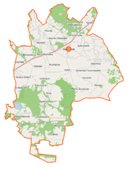
Polski: Mapa gminy Żabia Wola, Polska
English: Map of Gmina Żabia Wola, Poland |
|||||||||
| Date | ||||||||||
| Source | You may find a page on the OpenStreetMap wiki page for Żabia Wola (gmina) | |||||||||
| Creator |
OpenStreetMap contributors OpenStreetMap contributors |
|||||||||
| Permission (Reusing this file) |
OpenStreetMap data is available under the Open Database License (details). Map tiles are licensed under the Creative Commons Attribution-ShareAlike 2.0 license (CC-BY-SA 2.0).
This file is licensed under the Creative Commons Attribution-Share Alike 2.0 Generic license.
|
|||||||||
| Geotemporal data | ||||||||||
| Bounding box |
|
|||||||||
| Georeferencing | If inappropriate please set warp_status = skip to hide. | |||||||||
File history
Click on a date/time to view the file as it appeared at that time.
| Date/Time | Thumbnail | Dimensions | User | Comment | |
|---|---|---|---|---|---|
| current | 10:02, 12 September 2014 | | 701 × 922 (121 KB) | VanWiel (talk | contribs) | {{Information |Description= |Source= |Date= |Author= |Permission= |other_versions= }} |
| 11:11, 10 July 2014 |  | 698 × 920 (247 KB) | VanWiel (talk | contribs) | map | |
| 11:03, 10 July 2014 |  | 715 × 926 (138 KB) | VanWiel (talk | contribs) | {{OpenStreetMap | name = Żabia Wola (gmina) | location = Żabia Wola (gmina) | description = {{pl|Mapa gminy Żabia Wola, Polska}} {{en|Map of Gmina Żabia Wola, Poland}} | top = 52.0761 | left =... |
You cannot overwrite this file.
File usage on Commons
The following page uses this file:
File usage on other wikis
The following other wikis use this file:
- Usage on es.wikipedia.org
- Usage on pl.wikipedia.org
- Żabia Wola (gmina)
- Skuły
- Grzegorzewice (powiat grodziski)
- Bieniewiec
- Bolesławek
- Ciepłe A
- Grzymek
- Huta Żabiowolska
- Kaleń-Towarzystwo
- Musuły
- Nowa Bukówka
- Ojrzanów-Towarzystwo
- Oddział (wieś)
- Pieńki Słubickie
- Pieńki Zarębskie
- Przeszkoda (województwo mazowieckie)
- Redlanka
- Rumianka
- Siestrzeń
- Słubica A
- Słubica B
- Słubica Dobra
- Słubica-Wieś
- Wycinki Osowskie
- Bartoszówka (województwo mazowieckie)
- Ciepłe (województwo mazowieckie)
- Jastrzębnik (województwo mazowieckie)
- Ojrzanów (województwo mazowieckie)
- Osowiec (województwo mazowieckie)
- Grzmiąca (powiat grodziski)
- Kaleń (powiat grodziski)
- Lasek (powiat grodziski)
- Lisówek (powiat grodziski)
- Petrykozy (powiat grodziski)
- Piotrkowice (powiat grodziski)
- Władysławów (powiat grodziski)
- Zalesie (powiat grodziski)
- Zaręby (powiat grodziski)
- Żabia Wola (powiat grodziski)
- Żelechów (powiat grodziski)
- Rezerwat przyrody Skulski Las
- Stara Bukówka
- Józefina (województwo mazowieckie)
- Rezerwat przyrody Skulskie Dęby
- Parafia Zwiastowania Najświętszej Maryi Panny w Ojrzanowie
- Grzegorzewice (przystanek kolejowy)
- Karczunek (rzeka)
- Ojcówek
- Prywatne Muzeum w Petrykozach
View more global usage of this file.
_location_map.png)
_location_map.png&oldid=499497703)