File:Šilinkův důl, CZ160804-052.jpg
Jump to navigation
Jump to search

Size of this preview: 800 × 533 pixels. Other resolutions: 320 × 213 pixels | 640 × 427 pixels | 1,024 × 683 pixels | 1,280 × 853 pixels | 2,560 × 1,706 pixels | 4,811 × 3,207 pixels.
Original file (4,811 × 3,207 pixels, file size: 6.92 MB, MIME type: image/jpeg)
Captions
Captions
Add a one-line explanation of what this file represents
Summary
[edit]
| Description |
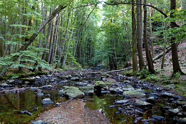
English: Natural Park The valley of Krounka and Novohradka. Photo location - Czechia, Hněvětice (part of municipality Skuteč), Krounka river.
Čeština: Přírodní park Údolí Krounky a Novohradky. Foto lokace - Česko, Hněvětice (část obce Skuteč), řeka Krounka.
Faktografie CZ: Balvanité koryto řeky Krounky v hlubokém údolí soutěsky Šilinkův důl prezentuje zajímavou geologickou minulost Skutečské pahorkatiny v Železných horách. Ve směru toku řeky od Kutřína až po soutok s Novohradkou v Dolech na katastrálním území Luže je meandrující Krounka součástí Přírodního parku Údolí Krounky a Novohradky s přirozeným původním korytem, výstupy skal nad ním a charakteristickou okolní zelení a lesním porostem. Šilinkův důl tvoří jednu z nejatraktivnějších částí přírodního parku vyhlášeného v roce 1998 na ploše cca 511 ha za účelem ochrany členité krajiny kolem Krounky a Novohradky. Území je součástí Národního geoparku Železné hory s mnoha dalšími geologicky významnými lokalitami. Podél koryta řeky je vedena turistická červeně značené trasa Klubu českých turistů. Významná je možnost poznání charakteristické krajiny s řekou Krounkou od jejího prameniště nad Krounou podél jejího toku po lesních cestách a počínaje Krounou po turistické značené trase s atraktivními místy, údolím Kablaně, Šilinkovým dolem, hradem Rychmburk až k soutoku Krounky s Novohradkou nedaleko zříceniny hradu Košumberk. |
| Date | |
| Source | Own work |
| Author | Josef Kreuz (PEPan) |
| Camera location | | View this and other nearby images on: OpenStreetMap |
|---|
Informace 2015-12-09: Česká centrála cestovního ruchu (Czech Tourism) - Šilinkův důl http://www.kudyznudy.cz/Aktivity-a-akce/Aktivity/Silinkuv-dul---via-ferrata.aspx
Licensing
[edit]
I, the copyright holder of this work, hereby publish it under the following license:
This file is licensed under the Creative Commons Attribution-Share Alike 4.0 International license.
- You are free:
- to share – to copy, distribute and transmit the work
- to remix – to adapt the work
- Under the following conditions:
- attribution – You must give appropriate credit, provide a link to the license, and indicate if changes were made. You may do so in any reasonable manner, but not in any way that suggests the licensor endorses you or your use.
- share alike – If you remix, transform, or build upon the material, you must distribute your contributions under the same or compatible license as the original.
File history
Click on a date/time to view the file as it appeared at that time.
| Date/Time | Thumbnail | Dimensions | User | Comment | |
|---|---|---|---|---|---|
| current | 13:42, 29 November 2016 | | 4,811 × 3,207 (6.92 MB) | PEPan (talk | contribs) | User created page with UploadWizard |
You cannot overwrite this file.
File usage on Commons
There are no pages that use this file.
File usage on other wikis
The following other wikis use this file:
- Usage on cs.wikipedia.org