File:Łobez (gmina) location map.png
Jump to navigation
Jump to search

Size of this preview: 572 × 599 pixels. Other resolutions: 229 × 240 pixels | 458 × 480 pixels | 928 × 972 pixels.
Original file (928 × 972 pixels, file size: 71 KB, MIME type: image/png)
Captions
Captions
Add a one-line explanation of what this file represents
| Description |
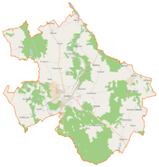
Polski: Mapa gminy Łobez, Polska
English: Map of Gmina Łobez, Poland |
|||||||||
| Date | ||||||||||
| Source | You may find a page on the OpenStreetMap wiki page for Łobez (gmina) | |||||||||
| Creator |
OpenStreetMap contributors OpenStreetMap contributors |
|||||||||
| Permission (Reusing this file) |
OpenStreetMap data is available under the Open Database License (details). Map tiles are licensed under the Creative Commons Attribution-ShareAlike 2.0 license (CC-BY-SA 2.0).
This file is licensed under the Creative Commons Attribution-Share Alike 2.0 Generic license.
|
|||||||||
| Geotemporal data | ||||||||||
| Bounding box |
|
|||||||||
| Georeferencing | If inappropriate please set warp_status = skip to hide. | |||||||||
File history
Click on a date/time to view the file as it appeared at that time.
| Date/Time | Thumbnail | Dimensions | User | Comment | |
|---|---|---|---|---|---|
| current | 15:17, 28 March 2015 | | 928 × 972 (71 KB) | VanWiel (talk | contribs) | {{OpenStreetMap | name = Łobez (gmina) | location = Łobez (gmina) | description = {{pl|Mapa gminy Łobez, Polska}} {{en|Map of Gmina Łobez, Poland}} | top = 53.7526 | bottom = 53.5546 | left... |
You cannot overwrite this file.
File usage on Commons
There are no pages that use this file.
File usage on other wikis
The following other wikis use this file:
- Usage on fr.wikipedia.org
- Przyborze (Poméranie-Occidentale)
- Trzeszczyna
- Bełczna
- Budziszcze
- Dalno
- Bonin (Łobez)
- Byszewo (Łobez)
- Dobieszewo (Poméranie-Occidentale)
- Grabowo (Łobez)
- Karwowo (Łobez)
- Klępnica
- Kołdrąb (Poméranie-Occidentale)
- Łobżany
- Meszne
- Niegrzebia
- Polakowo (Łobez)
- Pomorzany (Łobez)
- Poradz (Łobez)
- Prusinowo (Łobez)
- Rożnowo Łobeskie
- Rynowo (Poméranie-Occidentale)
- Rynowo-Kolonia
- Suliszewice (Poméranie-Occidentale)
- Tarnowo (Łobez)
- Unimie
- Worowo
- Wysiedle
- Zachełmie (Poméranie-Occidentale)
- Zagórzyce (Poméranie-Occidentale)
- Zajezierze (Poméranie-Occidentale)
- Zakrzyce (Poméranie-Occidentale)
- Zdzisławice (Poméranie-Occidentale)
- Usage on pl.wikipedia.org
- Łobez
- Łobez (gmina)
- Bełczna
- Dalno
- Klępnica
- Łobżany
- Niegrzebia
- Rożnowo Łobeskie
- Unimie
- Worowo (wieś w województwie zachodniopomorskim)
- Wysiedle
- Dobieszewo (województwo zachodniopomorskie)
- Przyborze (województwo zachodniopomorskie)
- Rynowo (wieś w województwie zachodniopomorskim)
- Suliszewice (województwo zachodniopomorskie)
- Zagórzyce (województwo zachodniopomorskie)
- Zajezierze (województwo zachodniopomorskie)
- Bonin (powiat łobeski)
View more global usage of this file.
_location_map.png)
_location_map.png&oldid=464424320)