File:Übersichtskarte des Vorkommens nutzbarer Mineral-Lagerstätten im Bergrevier Wied.png
Jump to navigation
Jump to search
Size of this preview: 434 × 599 pixels. Other resolutions: 174 × 240 pixels | 348 × 480 pixels | 556 × 768 pixels | 742 × 1,024 pixels | 1,509 × 2,082 pixels.
Original file (1,509 × 2,082 pixels, file size: 7.01 MB, MIME type: image/png)
Captions
Captions
Add a one-line explanation of what this file represents
Summary
[edit]
| Description |
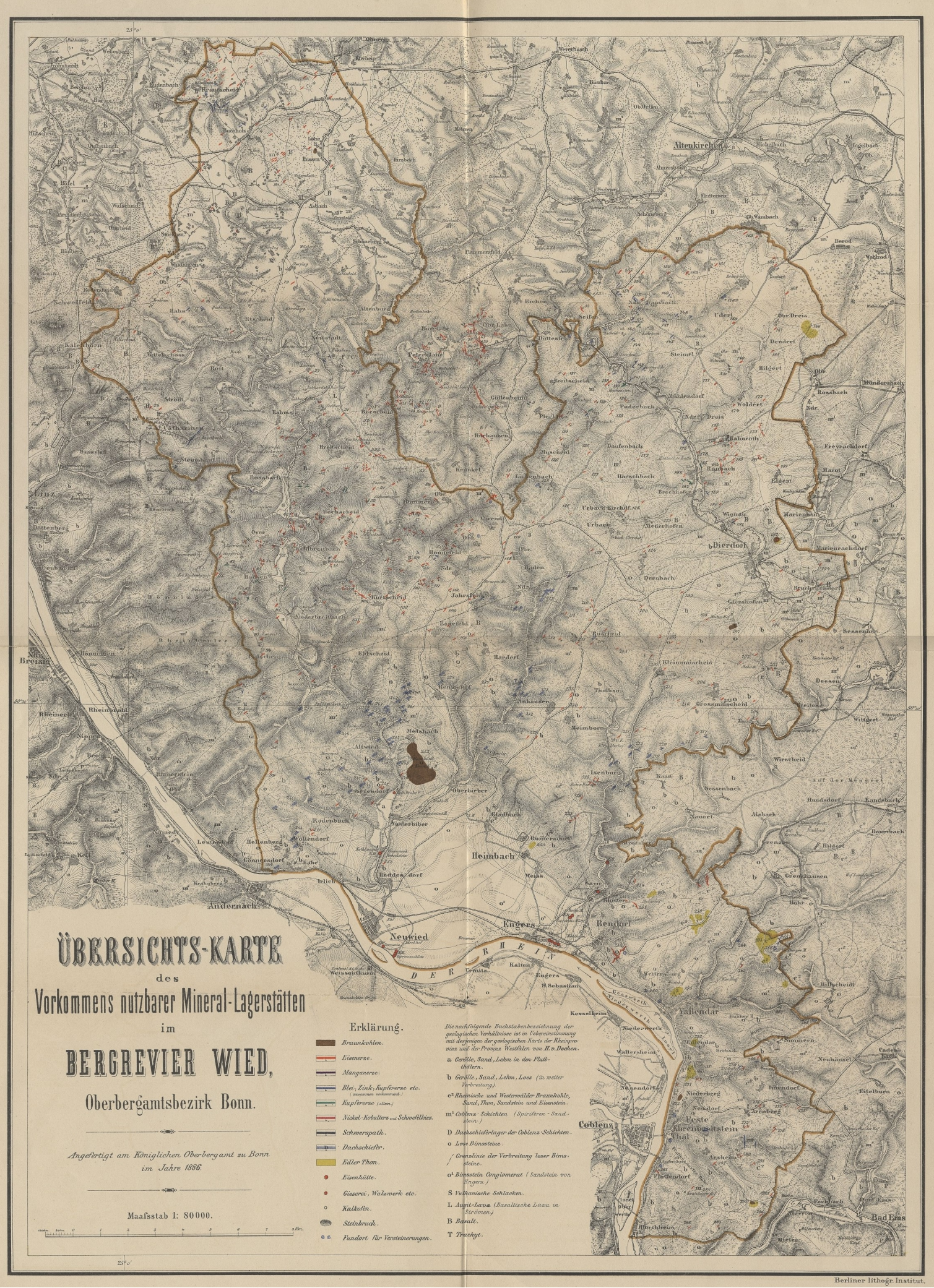
English: Map of the' mining district Wied' of 1886, Prussia Deutsch: Karte des 'Bergreviers Wied' von 1886 unter Preussischer Herrschaft. Übersichtskarte des Vorkommens nutzbarer Mineral-Lagerstätten im Bergrevier Wied |
| Date | |
| Source | Book "Beschreibung des Bergreviers Wied", Bonn, 1888 |
| Author | Dr. Karl Diesterweg |
the mining district Wied was a sub mining ditrict of 'Oberbergamt Bonn'
Licensing
[edit]
|
This work is in the public domain in its country of origin and other countries and areas where the copyright term is the author's life plus 70 years or fewer. This work is in the public domain in the United States because it was published (or registered with the U.S. Copyright Office) before January 1, 1929. | |
| This file has been identified as being free of known restrictions under copyright law, including all related and neighboring rights. | |
File history
Click on a date/time to view the file as it appeared at that time.
| Date/Time | Thumbnail | Dimensions | User | Comment | |
|---|---|---|---|---|---|
| current | 14:15, 13 September 2017 | | 1,509 × 2,082 (7.01 MB) | Thariama (talk | contribs) | full map |
| 14:10, 13 September 2017 |  | 1,524 × 1,931 (6.37 MB) | Thariama (talk | contribs) | User created page with UploadWizard |
You cannot overwrite this file.
File usage on Commons
There are no pages that use this file.