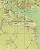
File:Übersichtskarte Luzern 1890.png
From Wikimedia Commons, the free media repository
Jump to navigation
Jump to search

Size of this preview: 800 × 554 pixels. Other resolutions: 320 × 221 pixels | 640 × 443 pixels | 1,024 × 709 pixels | 1,280 × 886 pixels | 1,962 × 1,358 pixels.
Original file (1,962 × 1,358 pixels, file size: 6.28 MB, MIME type: image/png)
File information
Structured data
Captions
Captions
Add a one-line explanation of what this file represents
Standort des Brünigbahnhofs südöstlich des Luzerner Bahnhofs
Any autoconfirmed user can overwrite this file from the same source. Please ensure that overwrites comply with the guideline.
Summary
[edit]| DescriptionÜbersichtskarte Luzern 1890.png |
Deutsch: Übersichtsplan der Stadt Luzern mit der officiellen neuen Häusernummerierung von 1890. Maßstab 1:4000. Verlag von E.Wegner,Kartographisches Atelier Luzern. |
||||||
| Date | |||||||
| Source | Stadtarchiv Luzern, Signatur E2a/017 https://staatsarchiv.lu.ch/schaufenster/karten_stadtansichten/luzern_stadt_1890 | ||||||
| Author | Unknown authorUnknown author | ||||||
| Other versions |
|
Licensing
[edit]| Public domainPublic domainfalsefalse |
The author of this image from Switzerland is unknown, and the image was published at least 70 years ago. It is therefore in the public domain in Switzerland by virtue of Art. 31 of the Swiss Copyright Act.
čeština | Deutsch | English | français | italiano | македонски | Nederlands | українська | +/− |
 |
File history
Click on a date/time to view the file as it appeared at that time.
| Date/Time | Thumbnail | Dimensions | User | Comment | |
|---|---|---|---|---|---|
| current | 14:36, 26 July 2024 |  | 1,962 × 1,358 (6.28 MB) | Derkoenig (talk | contribs) | better quality |
| 08:12, 25 July 2024 |  | 449 × 309 (327 KB) | As610 (talk | contribs) | Uploaded a work by {{Unknown|author}} from Internet with UploadWizard |
You cannot overwrite this file.
File usage on Commons
The following 2 pages use this file:
Metadata
This file contains additional information such as Exif metadata which may have been added by the digital camera, scanner, or software program used to create or digitize it. If the file has been modified from its original state, some details such as the timestamp may not fully reflect those of the original file. The timestamp is only as accurate as the clock in the camera, and it may be completely wrong.
| Horizontal resolution | 37.78 dpc |
|---|---|
| Vertical resolution | 37.78 dpc |
| Software used |

