File:Ölgii regions map.svg
Jump to navigation
Jump to search

Size of this PNG preview of this SVG file: 554 × 599 pixels. Other resolutions: 222 × 240 pixels | 444 × 480 pixels | 710 × 768 pixels | 946 × 1,024 pixels | 1,893 × 2,048 pixels | 757 × 819 pixels.
Original file (SVG file, nominally 757 × 819 pixels, file size: 821 KB)
Captions
Captions
Add a one-line explanation of what this file represents
| Description |
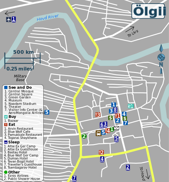
English: Travel map of Ölgii |
|||
| Date | ||||
| Source | OpenStreetMap | |||
| Author | Peter Fitzgerald, OpenStreetMap | |||
| Permission (Reusing this file) |
This file is licensed under the Creative Commons Attribution-Share Alike 2.0 Generic license.
|
|||
| Other versions |
PNG files: |
File history
Click on a date/time to view the file as it appeared at that time.
| Date/Time | Thumbnail | Dimensions | User | Comment | |
|---|---|---|---|---|---|
| current | 16:51, 25 May 2013 | | 757 × 819 (821 KB) | Peterfitzgerald (talk | contribs) | {{Information |Description ={{en|1=Travel map of Ölgii}} |Source =[http://openstreetmap.org OpenStreetMap] |Author =Peter Fitzgerald, [http://openstreetmap.org OpenStreetMap] |Date =2013-05-25 |Per... |
You cannot overwrite this file.
File usage on Commons
There are no pages that use this file.