File:Église Saint-Omer d'Ochtezeele (1).JPG
Original file (4,000 × 3,000 pixels, file size: 4.91 MB, MIME type: image/jpeg)
Captions
Captions
Summary
[edit]DescriptionÉglise Saint-Omer d'Ochtezeele (1).JPG |
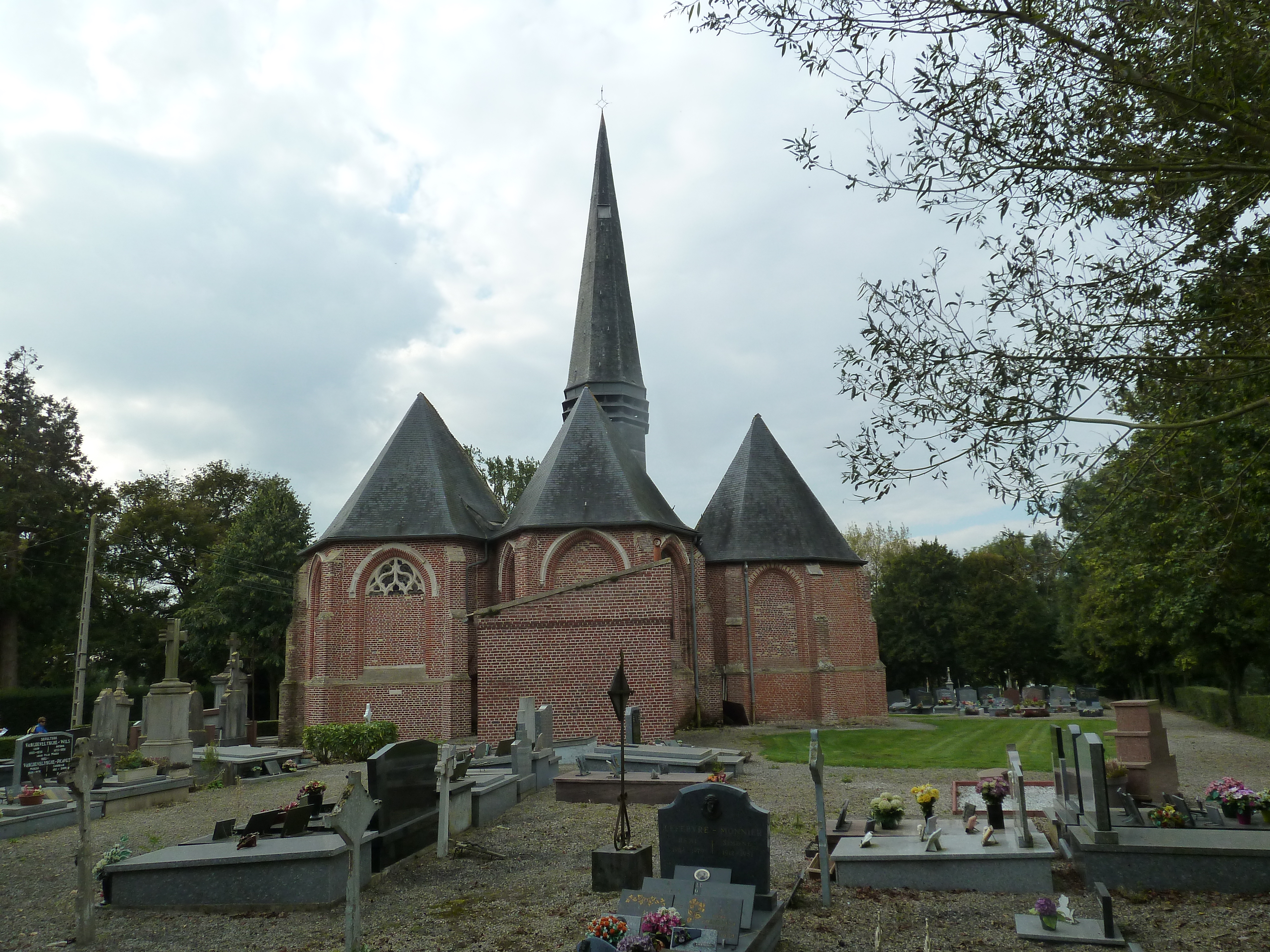
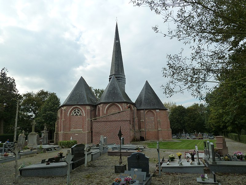
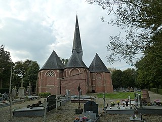
Français : Le chevet de l'église St Omer d'Ochtezeele
|
|
Date | ||
Source | Own work | |
Author | PIERRE ANDRE LECLERCQ |
Camera location | 50° 49′ 00.79″ N, 2° 24′ 14.45″ E ![]() | View this and other nearby images on: OpenStreetMap | ![]() |
---|
![]() |
This image was uploaded as part of L'Été des villes 2015.
বাংলা | brezhoneg | Deutsch | English | español | français | italiano | македонски | sicilianu | +/− |
Licensing
[edit]![w:en:Creative Commons](https://upload.wikimedia.org/wikipedia/commons/thumb/7/79/CC_some_rights_reserved.svg/90px-CC_some_rights_reserved.svg.png)
![attribution](https://upload.wikimedia.org/wikipedia/commons/thumb/1/11/Cc-by_new_white.svg/24px-Cc-by_new_white.svg.png)
![share alike](https://upload.wikimedia.org/wikipedia/commons/thumb/d/df/Cc-sa_white.svg/24px-Cc-sa_white.svg.png)
- You are free:
- to share – to copy, distribute and transmit the work
- to remix – to adapt the work
- Under the following conditions:
- attribution – You must give appropriate credit, provide a link to the license, and indicate if changes were made. You may do so in any reasonable manner, but not in any way that suggests the licensor endorses you or your use.
- share alike – If you remix, transform, or build upon the material, you must distribute your contributions under the same or compatible license as the original.
File history
Click on a date/time to view the file as it appeared at that time.
Date/Time | Thumbnail | Dimensions | User | Comment | |
---|---|---|---|---|---|
current | 08:05, 3 October 2014 | 4,000 × 3,000 (4.91 MB) | Pierre André Leclercq (talk | contribs) | User created page with UploadWizard |
You cannot overwrite this file.
File usage on Commons
The following page uses this file:
File usage on other wikis
The following other wikis use this file:
- Usage on fr.wikipedia.org
Metadata
This file contains additional information such as Exif metadata which may have been added by the digital camera, scanner, or software program used to create or digitize it. If the file has been modified from its original state, some details such as the timestamp may not fully reflect those of the original file. The timestamp is only as accurate as the clock in the camera, and it may be completely wrong.
Camera manufacturer | Panasonic |
---|---|
Camera model | DMC-TZ10 |
Exposure time | 1/400 sec (0.0025) |
F-number | f/4.5 |
ISO speed rating | 125 |
Date and time of data generation | 15:38, 2 October 2014 |
Lens focal length | 4.1 mm |
Latitude | 50° 49′ 0.79″ N |
Longitude | 2° 24′ 14.45″ E |
Orientation | Normal |
Horizontal resolution | 180 dpi |
Vertical resolution | 180 dpi |
Software used | Ver.1.2 |
File change date and time | 15:38, 2 October 2014 |
Y and C positioning | Co-sited |
Exposure Program | Landscape mode (for landscape photos with the background in focus) |
Exif version | 2.21 |
Date and time of digitizing | 15:38, 2 October 2014 |
Meaning of each component |
|
Image compression mode | 4 |
APEX exposure bias | 0 |
Maximum land aperture | 3.44 APEX (f/3.29) |
Metering mode | Pattern |
Light source | Unknown |
Flash | Flash did not fire, auto mode |
Supported Flashpix version | 1 |
Color space | sRGB |
Sensing method | One-chip color area sensor |
File source | Digital still camera |
Scene type | A directly photographed image |
Custom image processing | Normal process |
Exposure mode | Auto exposure |
White balance | Auto white balance |
Digital zoom ratio | 0 |
Focal length in 35 mm film | 25 mm |
Scene capture type | Standard |
Scene control | Low gain up |
Contrast | Normal |
Saturation | Normal |
Sharpness | Normal |
GPS time (atomic clock) | 13:36 |
Satellites used for measurement | 4 |
Receiver status | Measurement in progress |
Measurement mode | 2-dimensional measurement |
Measurement precision | Poor (2.4) |
Geodetic survey data used | WGS-84 |
GPS date | 2 October 2014 |
GPS tag version | 0.0.2.2 |
Structured data
Items portrayed in this file
depicts
some value
2 October 2014
50°49'0.79000"N, 2°24'14.45000"E
- Base Mérimée
- Mérimée without type parameter
- Mérimée with PA parameter
- Cultural heritage monuments in France with known IDs
- Images from Été des Villes 2015
- Uploaded via Campaign:ÉtédesVilles
- CC-BY-SA-3.0
- Self-published work
- Images from Wiki Loves Monuments 2014 in France − late
- Uploaded via Campaign:wlm-fr
- Dpt du Nord by PIERRE ANDRE LECLERCQ
- Files by User:Pierre André Leclercq
- Eglises by PIERRE ANDRE LECLERCQ
- France photographs taken on 2014-10-02