File:Åland Political Map-en.svg
Jump to navigation
Jump to search

Size of this PNG preview of this SVG file: 595 × 600 pixels. Other resolutions: 238 × 240 pixels | 476 × 480 pixels | 762 × 768 pixels | 1,016 × 1,024 pixels | 2,032 × 2,048 pixels | 996 × 1,004 pixels.
Original file (SVG file, nominally 996 × 1,004 pixels, file size: 219 KB)
Captions
Captions
Add a one-line explanation of what this file represents
Summary
[edit]| Description |
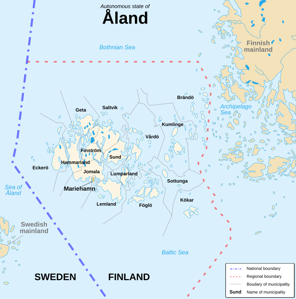
English: Political map of the autonomous finnish province of Åland, in english. Shows the national, regional and municipal boundaries about Åland islands. Français : Carte politique de l'État libre associé d'Åland, en anglais. La carte montre les frontières internationales, régionales et municipales concernant l'archipel d'Åland. |
||
| Date | |||
| Source |
English: Image:Alandmunicipalities.png and Image:Åland map.png, from Demis (see the approval e-mail and Demis forum). Français : Image:Alandmunicipalities.png et Image:Åland map.png, elles-même basées sur le site internet de Demis (voir le courriel d'autorisation et le forum de Demis). |
||
| Author | Sémhur (talk) | ||
| Other versions |
|
||
| Attribution (required by the license) | © Sémhur / Wikimedia Commons / | ||
| SVG | W3C-validity not checked.
|
||
| Atelier graphique |

| Camera location | | View this and other nearby images on: OpenStreetMap |
|---|
Licensing
[edit]
I, the copyright holder of this work, hereby publish it under the following licenses:
| Copyleft: This work of art is free; you can redistribute it and/or modify it according to terms of the Free Art License. You will find a specimen of this license on the Copyleft Attitude site as well as on other sites. |
This file is licensed under the Creative Commons Attribution-Share Alike 4.0 International, 3.0 Unported, 2.5 Generic, 2.0 Generic and 1.0 Generic license.
- You are free:
- to share – to copy, distribute and transmit the work
- to remix – to adapt the work
- Under the following conditions:
- attribution – You must give appropriate credit, provide a link to the license, and indicate if changes were made. You may do so in any reasonable manner, but not in any way that suggests the licensor endorses you or your use.
- share alike – If you remix, transform, or build upon the material, you must distribute your contributions under the same or compatible license as the original.
You may select the license of your choice.
File history
Click on a date/time to view the file as it appeared at that time.
| Date/Time | Thumbnail | Dimensions | User | Comment | |
|---|---|---|---|---|---|
| current | 16:11, 21 August 2007 | | 996 × 1,004 (219 KB) | Sémhur (talk | contribs) | {{Information |Description=Political map of the autonomous finnish province of Åland, in english.<br/> Shows the national, regional and municipal boundaries about Åland islands. |Source=Own work. Based on Image:Alandmunicipalities.png and [[:Image: |
You cannot overwrite this file.
File usage on Commons
The following 18 pages use this file:
- Åland
- File:Åland Political Map-sv.svg
- Category:2007 in Åland
- Category:2008 in Åland
- Category:2011 in Åland
- Category:Aviation in Åland
- Category:Births in Åland
- Category:Bridges in Åland
- Category:Category navigational templates for Åland
- Category:Companies of Åland
- Category:Deaths in Åland
- Category:Disc golf courses in Åland
- Category:Islands of Åland
- Category:Lakes of Åland
- Category:Lighthouses in Åland
- Category:Maps of Åland
- Category:Water transport in Åland
- Category:Åland
File usage on other wikis
The following other wikis use this file:
- Usage on ca.wikipedia.org
- Usage on en.wikipedia.org
- Usage on es.wikipedia.org
- Usage on ga.wikipedia.org
- Usage on gl.wikipedia.org
- Usage on hy.wikipedia.org
- Usage on li.wikipedia.org
- Usage on nl.wikipedia.org
- Usage on ru.wikipedia.org
- Usage on www.wikidata.org