File:Ärgera Auengebiet 01.jpg
Jump to navigation
Jump to search

Size of this preview: 800 × 533 pixels. Other resolutions: 320 × 213 pixels | 640 × 427 pixels | 1,024 × 683 pixels | 1,280 × 853 pixels | 2,560 × 1,707 pixels | 4,752 × 3,168 pixels.
Original file (4,752 × 3,168 pixels, file size: 14.17 MB, MIME type: image/jpeg)
Captions
Captions
Add a one-line explanation of what this file represents
Summary
[edit]| Description |
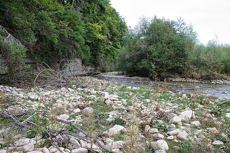
Deutsch: Das Auengebiet und das Amphibienlaichgebiet von nationaler Bedeutung an der Ärgera, die hier in einem tiefen Graben fliesst und Platz für Geschiebehaufen, Schwemmholz, Reisig und einen mäandernden Lauf hat. Die Ärgera schafft bei Hochwasser neue Lebensräume für Pionierpflanzen und Amphibien. English: The alluvial site and Amphibian Spawing Area of national importance on the Gerine River, which flows here in a deep ditch and has room for bedload piles, driftwood and brushwood and a meandering course. As a result of floods, the Ärgera repeatedly creates new habitats for pioneer plants and amphibians. Français : La zone alluviale et le site de reproduction des amphibiens d'importance nationale de la Ärgera, qui s'écoule ici dans un fossé profond, laissant la place à des tas d'alluvions, de bois flottant et de branchages et à un cours méandreux. Suite aux crues, la Ärgera crée régulièrement de nouveaux habitats pour les plantes pionnières et les amphibiens. |
||||
| Date | |||||
| Source | Own work | ||||
| Author | Martin Thurnherr | ||||
| Permission (Reusing this file) |
|
||||
| Protected |
|

| Object location | | View this and other nearby images on: OpenStreetMap |
|---|
Licensing
[edit]
I, the copyright holder of this work, hereby publish it under the following license:
This file is licensed under the Creative Commons Attribution-Share Alike 4.0 International license.
Attribution: Martin Thurnherr
- You are free:
- to share – to copy, distribute and transmit the work
- to remix – to adapt the work
- Under the following conditions:
- attribution – You must give appropriate credit, provide a link to the license, and indicate if changes were made. You may do so in any reasonable manner, but not in any way that suggests the licensor endorses you or your use.
- share alike – If you remix, transform, or build upon the material, you must distribute your contributions under the same or compatible license as the original.
File history
Click on a date/time to view the file as it appeared at that time.
| Date/Time | Thumbnail | Dimensions | User | Comment | |
|---|---|---|---|---|---|
| current | 22:26, 21 December 2022 | | 4,752 × 3,168 (14.17 MB) | Matutinho (talk | contribs) | {{Information |Description=Das Auengebiet von nationaler Bedeutung an der Ärgera/Gerine |Source={{own}} |Date=2022-09-13 |Author= Martin Thurnherr |Permission={{User:Matutinho/Template:Credits}} |other_versions= }} Category:Alluvial sites of national importance (Switzerland) |
You cannot overwrite this file.
File usage on Commons
There are no pages that use this file.
File usage on other wikis
The following other wikis use this file:
- Usage on de.wikipedia.org
- Usage on www.wikidata.org