File:"Port Hudson and its Defenses.".jpg
Jump to navigation
Jump to search

Size of this preview: 437 × 599 pixels. Other resolutions: 175 × 240 pixels | 350 × 480 pixels | 560 × 768 pixels | 747 × 1,024 pixels | 1,494 × 2,048 pixels | 4,415 × 6,052 pixels.
Original file (4,415 × 6,052 pixels, file size: 8.75 MB, MIME type: image/jpeg)
Captions
Captions
Add a one-line explanation of what this file represents
Summary
[edit]
| Description |
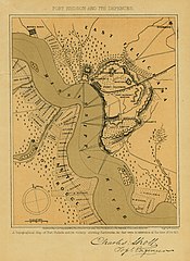
English: Print of a map showing Port Hudson and surrounding areas, including the Mississippi River. "PORT HUDSON AND ITS DEFENSES" (printed above map). "Charles Snoll Topl. Engineer." (signature printed below map). ** NOTE - [surname appears to be "Sholl" as the "h" in "Charles" is similar to the "h" in Sholl. The "n" in "Engineer" is not similar to these two h's.]
Taken from "The Great Civil War, vol. III." by Robert Torres, M.D. and Benjamin G. Smith. Book was published by Virtue and Yorston, 1865. Title: "Port Hudson and its Defenses." |
| Date | |
| Source |
Missouri History Museum URL: http://images.mohistory.org/image/E3582236-5BCA-5C90-5C1F-26DDA10C0F1B//original.jpg Gallery: http://collections.mohistory.org/resource/156328 |
| Author | Rae Smith, Virtue and Yorston |
| Permission (Reusing this file) |
UND - Copyright undetermined |
| Identifier | P0084-0731 |
| Part of | Maps |
| Subjects | Civil War, 1861-1865 map Port Hudson defenses Topographic maps earthworks Mississippi River Charles Snoll Virtue and Yorston Rae Smith W. Kemble |
| Resource | 156328 |
Licensing
[edit]
|
This is a faithful photographic reproduction of a two-dimensional, public domain work of art. The work of art itself is in the public domain for the following reason:
The official position taken by the Wikimedia Foundation is that "faithful reproductions of two-dimensional public domain works of art are public domain".
This photographic reproduction is therefore also considered to be in the public domain in the United States. In other jurisdictions, re-use of this content may be restricted; see Reuse of PD-Art photographs for details. |
File history
Click on a date/time to view the file as it appeared at that time.
| Date/Time | Thumbnail | Dimensions | User | Comment | |
|---|---|---|---|---|---|
| current | 06:41, 16 August 2017 | | 4,415 × 6,052 (8.75 MB) | Fæ (talk | contribs) | Missouri History Museum. "Port Hudson and its Defenses." 1865to1899 #143.9 of 339 |
You cannot overwrite this file.
File usage on Commons
There are no pages that use this file.