File:"Mad" Jack Fullers Grave, Brightling - geograph.org.uk - 1010450.jpg
Jump to navigation
Jump to search

Size of this preview: 450 × 600 pixels. Other resolutions: 180 × 240 pixels | 480 × 640 pixels.
Original file (480 × 640 pixels, file size: 213 KB, MIME type: image/jpeg)
Captions
Captions
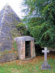
Pyramidal tomb of Jack Fuller in Brightling Churchyard.
Summary
[edit]
| Description |
English: "Mad" Jack Fullers Grave, Brightling, near to Brightling, East Sussex, Great Britain.
Fuller, a local landowner who made his money from the Sussex Iron industry, planned his tomb a full 24 years before he died on 11th April 1834. he got permission from the vicar by providing a surrounding wall for the church, a new lychgate and a new organ. He was rumoured to have been buried in this pyramid, sitting upright at a table wearing a top hat and holding a glass of port. unfortunately when the tomb was renovated this was found to be untrue. |
| Date | |
| Source | From geograph.org.uk; transferred by User:Kurpfalzbilder.de using geograph_org2commons. |
| Author | Kevin Gordon |
| Permission (Reusing this file) |
Creative Commons Attribution Share-alike license 2.0 |
| Attribution (required by the license) | Kevin Gordon / "Mad" Jack Fullers Grave, Brightling / |
| Camera location | | View this and other nearby images on: OpenStreetMap |
|---|
| Object location | | View this and other nearby images on: OpenStreetMap |
|---|
_region:GB-ENG_heading:157.00&language=en)
Licensing
[edit]

|
This image was taken from the Geograph project collection. See this photograph's page on the Geograph website for the photographer's contact details. The copyright on this image is owned by Kevin Gordon and is licensed for reuse under the Creative Commons Attribution-ShareAlike 2.0 license.
|
This file is licensed under the Creative Commons Attribution-Share Alike 2.0 Generic license.
Attribution: Kevin Gordon
- You are free:
- to share – to copy, distribute and transmit the work
- to remix – to adapt the work
- Under the following conditions:
- attribution – You must give appropriate credit, provide a link to the license, and indicate if changes were made. You may do so in any reasonable manner, but not in any way that suggests the licensor endorses you or your use.
- share alike – If you remix, transform, or build upon the material, you must distribute your contributions under the same or compatible license as the original.
File history
Click on a date/time to view the file as it appeared at that time.
| Date/Time | Thumbnail | Dimensions | User | Comment | |
|---|---|---|---|---|---|
| current | 13:50, 8 October 2010 | | 480 × 640 (213 KB) | File Upload Bot (Magnus Manske) (talk | contribs) |
You cannot overwrite this file.
File usage on Commons
There are no pages that use this file.