Commons:Featured picture candidates/File:Languages of Northern Sumatra en.svg
Jump to navigation
Jump to search

Voting period is over. Please don't add any new votes.Voting period ends on 17 Jun 2019 at 21:16:15 (UTC)
Visit the nomination page to add or modify image notes.

- Category: Commons:Featured pictures/Non-photographic media/Maps#Maps_of_Asia
 Info created by Masjawad99 - uploaded by Masjawad99 - nominated by Mimihitam -- Mimihitam (talk) 21:16, 8 June 2019 (UTC)
 Support -- Mimihitam (talk) 21:16, 8 June 2019 (UTC)
 Request as you've made this in Inkscape and it's purely vector shapes, this should be uploaded and nominated as a svg file instead of bitmap graphics. – LucasT 21:26, 8 June 2019 (UTC)
- Tag Masjawad99 Mimihitam (talk) 21:45, 8 June 2019 (UTC)
- @Lucasbosch and Mimihitam: Does this work? Masjawad99 (talk) 00:27, 9 June 2019 (UTC)
- Yes, of course. You can move/rename this nomination page to have the svg file extension and change out the embedded file. – LucasT 07:56, 9 June 2019 (UTC)
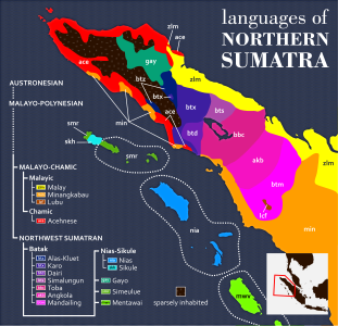
 Comment This really belongs in the Featured_pictures/Non-photographic_media/Maps#Maps_of_Asia category, and the legend entry for the Malay language should use black text over the yellow. – LucasT 09:39, 9 June 2019 (UTC)
- Tag @Masjawad99 — Preceding unsigned comment added by Mimihitam (talk • contribs) 10:20, 9 June 2019 (UTC)
- @Lucasbosch and Mimihitam: Done. Masjawad99 (talk) 10:34, 10 June 2019 (UTC)
- Comment - Somewhere, it should be noted that all the requested changes have been made. It's a very nice map, but there's one further needed change: According to the locator map at the lower right, a large part of the Malay Peninsula is in this map, but actually, it isn't. Therefore, the locator map needs to be edited accordingly. Once that's done, I will support. A few of the abbreviations, such as "zlm" for "Malay" and "lcf" for Lubu seem a bit strange, but they're clearly explained, and that's what really matters. -- Ikan Kekek (talk) 10:55, 9 June 2019 (UTC)
- @Ikan Kekek: How about now? As for lcf and zlm, they are actually not abbreviations, but ISO 639-3 language codes. I have clarified it in the description. Masjawad99 (talk) 10:34, 10 June 2019 (UTC)
 Oppose Not impressive --A-wiki-guest-user (talk) 07:39, 10 June 2019 (UTC)
- Comment - Thanks a lot, Masjawad99. Forgive me, I found another problematic thing on the map: "non-indigenous or sparsely inhabited". Any so-called "non-indigenous" language should probably be included on the map if it's a map of current language usage, but I can clearly see that the areas in question are in the interior, and therefore must be sparsely inhabited, with presumably an aboriginal population of some kind if there are people there. So wouldn't "sparsely inhabited" be a sufficient description? -- Ikan Kekek (talk) 11:12, 10 June 2019 (UTC)
- @Ikan Kekek: Done. Don't hesitate to let me know if there are other things that I should fix. Masjawad99 (talk) 23:30, 10 June 2019 (UTC)
- Terima kasih. Support - As I said above, this is a nice map. I find it attractive (I like the waves in the water), it's clear and can serve as a good example for similar maps that cover other parts of the world. -- Ikan Kekek (talk) 02:43, 11 June 2019 (UTC)
- Terima kasih.
- Oppose Perhaps a VI but it's too cluttered for it to be pleasant enough to look at for looking's sake. Daniel Case (talk) 14:09, 11 June 2019 (UTC)
 I withdraw my nomination--Mimihitam (talk) 21:28, 11 June 2019 (UTC)