Category:Wooden fences in the United Kingdom
Jump to navigation
Jump to search
Media in category "Wooden fences in the United Kingdom"
The following 164 files are in this category, out of 164 total.
-
 17th-century Church Lodge cottage Little Easton Essex England.jpg 4,801 × 3,223; 14.48 MB
-
 18th century Hatfield Park at Hatfield Broad Oak Essex England.jpg 3,000 × 2,250; 4.99 MB
-
 1992 Vauxhall Cavalier 1.6 L (14708864064).jpg 4,272 × 2,848; 4.75 MB
-
 20060330-008-holland-park-fence.jpg 3,039 × 2,014; 1.39 MB
-

-
-

-
 Chelmsford Road and South Street junction, Great Waltham, Essex, England.JPG 5,472 × 3,648; 12.19 MB
-
 Chelmsford Road beige house, Great Waltham, Essex, England.JPG 3,648 × 4,494; 11.55 MB
-
 Balustrade and steps Hatfield House Old Palace Hertfordshire England.jpg 5,472 × 3,648; 27.13 MB
-
 Border and fence Goodnestone Dover Kent England.jpg 3,648 × 5,472; 18.51 MB
-
 Brick cottages Goodnestone Dover Kent England 1.jpg 5,472 × 3,500; 16.04 MB
-
 Brick cottages Goodnestone Dover Kent England 2.jpg 5,168 × 3,504; 14.1 MB
-
 Bus stop at Nuthurst, West Sussex, England.jpg 4,584 × 3,438; 16.64 MB
-
 Garden fence and gate at Nuthurst, West Sussex, England.jpg 3,000 × 2,000; 4.25 MB
-
 Fence and road verge at Hatfield Broad Oak Essex England.jpg 2,250 × 3,000; 5.9 MB
-
 Bus stop at night in Nuthurst, West Sussex, England.jpg 3,000 × 2,000; 4.99 MB
-
 Churchgate Street, Harlow, Essex ~ bay window white houses.jpg 2,626 × 3,500; 6.28 MB
-
 Footpath signpost on Tawney Lane, Stapleford Tawney, Essex, England.jpg 2,333 × 3,500; 6.69 MB
-
 River Ching footpath 06, South Chingford, Waltham Forest, London, England.jpg 4,000 × 3,000; 11.5 MB
-
 River Ching footpath 09, looking east over footbridge, South Chingford, London, England.jpg 4,000 × 3,000; 10.59 MB
-
 Street lamp ornament and gloriette with climbing rose at Boreham, Essex, England.jpg 2,333 × 3,500; 8.54 MB
-
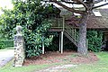 Cook's Farm barn staircase in Nuthurst village, West Sussex, England.jpg 5,000 × 3,333; 11.9 MB
-
 Easton Lodge Gardens, Little Easton, Essex, England private garden wall.jpg 6,240 × 4,160; 23.47 MB
-
 Garnon Bushes pub patio trellis, Coopersale, Epping, Essex, England.jpg 4,467 × 3,350; 11.12 MB
-
 St Alban the Martyr parish rooms at Coopersale, Essex, England 01.jpg 5,099 × 3,824; 16.88 MB
-
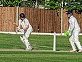
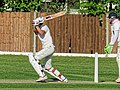 Dunmow CC v Felixstowe and Corinthians CC at Great Dunmow, Essex, England 086.jpg 3,913 × 2,935; 9.02 MB
-
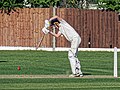 Dunmow CC v Felixstowe and Corinthians CC at Great Dunmow, Essex, England 087.jpg 3,938 × 2,954; 9.4 MB
-
 Dunmow CC v Felixstowe and Corinthians CC at Great Dunmow, Essex, England 088.jpg 4,063 × 3,047; 10.66 MB
-
 Dunmow CC v Felixstowe and Corinthians CC at Great Dunmow, Essex, England 089.jpg 3,236 × 3,235; 8.31 MB
-
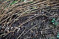 Highdown Gardens, Worthing, woven branch wattle fence.jpg 6,240 × 4,160; 22.64 MB
-
 City of London Cemetery graveyard at south Hunnable grave.jpg 3,860 × 5,147; 13.67 MB
-
 City of London Cemetery graveyard at south overgrown grave fence.jpg 5,964 × 3,355; 15.22 MB
-
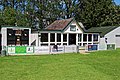
 High Roding Cricket Club cricket pavilion 01.jpg 4,428 × 2,943; 11.17 MB
-
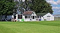
 High Roding Cricket Club cricket pavilion 02.jpg 4,507 × 3,007; 11.53 MB
-
 High Roding Cricket Club cricket pavilion 03.jpg 4,500 × 2,531; 10.76 MB
-
 High Roding Cricket Club boundary fence 01.jpg 4,535 × 3,401; 15.2 MB
-
 High Roding Cricket Club scorebox 01.jpg 3,222 × 4,296; 9.12 MB
-
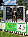 High Roding Cricket Club scorebox 02.jpg 3,287 × 4,383; 10.06 MB
-
 High Roding Cricket Club cricket pavilion 04.jpg 4,421 × 3,316; 11.08 MB
-
 Charlecote Park rustic post and rail fence Warwickshire England 01.jpg 6,240 × 4,160; 26.23 MB
-
 Charlecote Park rustic post and rail fence Warwickshire England 02.jpg 6,240 × 4,160; 28.29 MB
-
 A fence and hedgerow on Santon Lane at Stourmouth Kent England.jpg 2,000 × 3,000; 5.56 MB
-
 A fence with kissing gate at Woodland Trust wood Theydon Bois Essex England.JPG 5,324 × 3,426; 16.6 MB
-
 A K6 telephone box and utility poles Little Laver Road Essex England.jpg 2,000 × 3,000; 7.3 MB
-
 A kissing gate and fence at Woodland Trust wood Theydon Bois Essex England.JPG 5,472 × 3,648; 16.19 MB
-
 A lane at the west of High Beech, Essex, England.jpg 5,472 × 3,648; 16.75 MB
-

-

-
 A path and kissing gate at Woodland Trust wood Theydon Bois Essex England.JPG 3,648 × 4,432; 10.72 MB
-
 A path with kissing gate at Woodland Trust wood Theydon Bois Essex England.JPG 3,648 × 5,472; 17.09 MB
-
 A pond below the M11 embankment at Woodland Trust wood Theydon Bois Essex England.JPG 5,472 × 3,648; 13.96 MB
-
 A rose bush in Great Waltham, Essex, England.JPG 3,648 × 5,472; 10.57 MB
-
 Access road to Hatfield Park Essex England 4.jpg 3,000 × 2,250; 4.93 MB
-
 All Saints Church, Nazeing, Essex, England ~ churchyard west style 01.JPG 5,472 × 3,648; 11.6 MB
-
 Along Mashbury Hall Lane from the north, Mashbury, Essex, England.JPG 5,472 × 3,648; 10.43 MB
-
 An aspect north with village hall and cottage at Shipley, West Sussex, England.JPG 5,385 × 3,526; 9.51 MB
-

-
 Arkesden Wicken Water bridge Essex, England.jpg 3,648 × 5,472; 28.93 MB
-
 Arthur Uther Pendragon.jpg 2,336 × 3,504; 1.7 MB
-
 Autumnal oak by a pond - geograph.org.uk - 1565712.jpg 480 × 640; 173 KB
-
 Barn Cottages, Dunham Massey-geograph-3973100.jpg 640 × 481; 330 KB
-
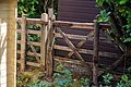
 Barn entrance gate at Easole Street, Nonington, Kent, England.jpg 2,000 × 3,000; 6.25 MB
-
 Flickr - ronsaunders47 - Get me to the wedding fast...jpg 1,599 × 872; 650 KB
-
 Beehive pub, Great Waltham, Essex, England.JPG 5,356 × 3,648; 11.36 MB
-
 Betts Lane field at Nazeing, Essex, England 01.JPG 5,472 × 3,648; 12.63 MB
-
 Betts Lane field at Nazeing, Essex, England 02.JPG 4,884 × 3,456; 10.16 MB
-
 Betts Lane rose and fence at Nazeing, Essex, England.JPG 5,472 × 3,648; 9.8 MB
-
 Boundary fence at Gernon Bushes Nature Reserve, Coopersale Essex England.jpg 2,000 × 3,000; 4.38 MB
-
 Boundary fence below the M11 at Woodland Trust wood Theydon Bois Essex England.JPG 5,472 × 3,648; 15.22 MB
-
 Boundary fence below the M11 embankment at Woodland Trust wood Theydon Bois Essex England.JPG 5,379 × 2,732; 10.53 MB
-
 Boundary fence overgrown below the M11 at Woodland Trust wood Theydon Bois Essex England.JPG 5,472 × 3,648; 17.57 MB
-
 Bourne Tributary - geograph.org.uk - 1165506.jpg 640 × 480; 114 KB
-

-
 Bridleway near Turkey Farm - geograph.org.uk - 604252.jpg 640 × 427; 126 KB
-
 Brighouse Boundary Walk Path Passing Through Woodland - geograph.org.uk - 4193979.jpg 4,000 × 3,000; 4.14 MB
-
 Church Street pub Broadstairs St Peters Kent England 1.jpg 3,648 × 5,472; 15.08 MB
-
 Canadian-Cross-61.jpg 2,048 × 1,365; 2.78 MB
-
 Canadian-Cross-71.jpg 2,048 × 1,365; 2.34 MB
-
 Canadian-Cross-74.jpg 1,024 × 1,536; 1.68 MB
-
 Clear Barn and Hog's Back, Puttenham.jpg 4,000 × 3,000; 2.21 MB
-
 Common Farm, Comberton, Cambs - geograph.org.uk - 98689.jpg 640 × 480; 237 KB
-
 Copsale fence and hedge ~ Copsale, Nuthurst, West Sussex, England.JPG 5,472 × 3,648; 13.37 MB
-
 Corse MMB 03.jpg 4,542 × 2,700; 4.89 MB
-
 Cottage in St James's Park at Evening.jpg 3,571 × 2,381; 2.98 MB
-
 Cranes Moor, bridge - geograph.org.uk - 1530372.jpg 640 × 480; 109 KB
-
 Deer fencing - geograph.org.uk - 125606.jpg 466 × 640; 87 KB
-
 Deer fencing, Charlecote Park - geograph.org.uk - 1568928.jpg 480 × 640; 120 KB
-
 Dog agility equipment - geograph.org.uk - 769656.jpg 640 × 480; 116 KB
-
 Dual use path, Richmond Park - geograph.org.uk - 1453370.jpg 640 × 480; 119 KB
-
 Parsonage Barn near East Hendred - geograph.org.uk - 1308823.jpg 640 × 409; 72 KB
-
 Elizabeth II post box K6 telephone box and utility poles Little Laver Road Essex England.jpg 3,000 × 2,000; 6.79 MB
-
 Farm fence in Watlington.jpg 1,818 × 1,228; 790 KB
-
 Fence and tree lined lawn Little Laver Road, Essex England.jpg 3,000 × 2,000; 6.64 MB
-
 Fence in Portland Park - geograph.org.uk - 1600229.jpg 640 × 480; 159 KB
-
 Field gate and fence at Monkton Kent England.jpg 3,000 × 2,000; 5.51 MB
-
 Footpath to Hollinshead Hall from Tockholes Road - geograph.org.uk - 1730379.jpg 2,592 × 1,944; 1.27 MB
-
 FOXFIELD CUMBRIA OCT 2013 (10123036993).jpg 5,158 × 2,984; 7.61 MB
-
 Fred C Palmer Malthouse Blunsdon.jpg 1,557 × 965; 376 KB
-
 Gallops near Basildon Park - geograph.org.uk - 1344923.jpg 640 × 425; 189 KB
-
 Garden parterre Old Palace Hatfield House Hertfordshire England.jpg 5,472 × 3,648; 30.32 MB
-
 Gloster Javelin 1508616.jpg 640 × 480; 125 KB
-
 Gloucestershire Airport, Staverton - geograph.org.uk - 421707.jpg 640 × 413; 177 KB
-
 Gloucestershire Airport, Staverton - geograph.org.uk - 453973.jpg 640 × 457; 331 KB
-

-

-
 Grantham railway station MMB 13.jpg 3,936 × 2,624; 3.49 MB
-
 Grantham railway station MMB 41.jpg 3,900 × 2,515; 3.11 MB
-
 Halifax Bomber Disaster Balkholme.jpg 640 × 480; 100 KB
-
 Hawkstone Park - geograph.org.uk - 1498761.jpg 640 × 480; 172 KB
-
 Hawkstone Park - geograph.org.uk - 1502272.jpg 480 × 640; 166 KB
-

-
 HLB-bullheadrail-protection-01.jpg 1,200 × 1,600; 883 KB
-
 HLB-bullheadrail-protection-02.jpg 1,200 × 1,600; 859 KB
-
 HLB-bullheadrail-protection-03.jpg 1,200 × 1,600; 859 KB
-
 Holdsworth Square - Victoria Road - geograph.org.uk - 2193522.jpg 640 × 480; 67 KB
-
 St Barnabas Church - geograph.org.uk - 1279328.jpg 640 × 480; 125 KB
-
 The Jurassic Way, Ketton - geograph.org.uk - 1738962.jpg 3,648 × 2,736; 2.27 MB
-
 Leeds and Bradford Road - geograph.org.uk - 1126422.jpg 640 × 424; 154 KB
-
 Lichen at Colgate West Sussex England.JPG 5,472 × 3,648; 11.47 MB
-
 Little memorial tucked in fence corner - geograph.org.uk - 1012006.jpg 640 × 480; 135 KB
-

-
 Marshwood Farm - geograph.org.uk - 133616.jpg 640 × 473; 77 KB
-
-
 New fence (7385198250).jpg 1,728 × 2,592; 774 KB
-
 Old wooden rails at Lymore Park IMG 3025.JPG 1,600 × 1,200; 525 KB
-

-
 Panorama of King Henry's Mound.jpg 4,463 × 1,101; 1.79 MB
-
 Parkland, Chilton Foliat - geograph.org.uk - 987848.jpg 640 × 480; 141 KB
-
 Playground, Lancaster 110.jpg 3,872 × 2,592; 1.27 MB
-
 Private Property - geograph.org.uk - 238894.jpg 480 × 640; 68 KB
-
 Radburn way - panoramio.jpg 3,264 × 2,448; 4.59 MB
-
 Ruined Fence, Clarence Wharf Road - geograph.org.uk - 326445.jpg 640 × 426; 75 KB
-
 Self supporting timber fence - geograph.org.uk - 1303909.jpg 640 × 479; 94 KB
-

-
 Smiths Motors after the fire - geograph.org.uk - 1853211.jpg 640 × 480; 163 KB
-
 Spiked fence in Cratfield, Suffolk, England.jpg 640 × 480; 140 KB
-
 Splattered Fence.JPG 2,048 × 1,536; 1.13 MB
-
 St Giles Church, Burnby.jpg 640 × 480; 91 KB
-
 Sturston Hall Farm Entrance (296735 d29217c6-by-John-Poyser).jpg 640 × 480; 117 KB
-
 The "poultiggery" at Cherryburn - geograph.org.uk - 779863.jpg 640 × 480; 96 KB
-
 The Beehive Flash - geograph.org.uk - 714340.jpg 640 × 480; 81 KB
-
 The fence around Lilford Park - geograph.org.uk - 1184903.jpg 640 × 480; 135 KB
-
 The Old Station - geograph.org.uk - 517389.jpg 640 × 480; 114 KB
-
 The vegetable garden, Trerice, Newlyn - geograph.org.uk - 1370946.jpg 640 × 480; 188 KB
-
 Thornton Viaduct 1 (2531310731).jpg 2,498 × 1,872; 4.17 MB
-
 Tornagrain Phase 1a (29614068877).jpg 1,099 × 731; 223 KB
-

-

-
 Unmade road, Blackthorpe - geograph.org.uk - 814345.jpg 640 × 480; 138 KB
-
 Uphill footpath - geograph.org.uk - 865962.jpg 480 × 640; 76 KB
-
 Visite du Branchage Juilet 2010 Saint Hélyi a.jpg 2,786 × 3,588; 11.92 MB
-
 Watermead Country Park, Leicester. - geograph.org.uk - 377514.jpg 640 × 439; 122 KB
-
 Welsh Fence.jpg 2,448 × 3,264; 3.7 MB
-
 Westminster garden clock - 2022-06-12 - Andy Mabbett.jpg 3,872 × 2,592; 4.42 MB
-
 Why did they do that. Hendre area, N-Wales, UK. - Flickr - Phlips photos.jpg 4,914 × 3,276; 9.56 MB
-
 Willingale, Essex, England - The Street fence and trees.JPG 5,472 × 3,648; 15.95 MB
-
 Wooden-fence-Holland-Park-20060330-009.jpg 3,031 × 2,006; 2.24 MB
-
 Woodland near Cold Overton - geograph.org.uk - 66501.jpg 640 × 480; 201 KB
-
 Bungalow on the Lisinaw Road - geograph.org.uk - 437653.jpg 640 × 480; 54 KB
-
 Cold Overton Grange - geograph.org.uk - 66523.jpg 640 × 480; 107 KB
-
 Crailing Old Parish Churchyard - geograph.org.uk - 615338.jpg 640 × 480; 166 KB
-
 Mayfield Valley - geograph.org.uk - 30121.jpg 567 × 378; 42 KB
-
 Woodman's Arms, Hammerpot-Worthing - geograph.org.uk - 4379.jpg 640 × 480; 66 KB


.jpg)


.jpg)


.jpg)


.jpg)


.jpg)
.jpg)


