Category:Watchfield
Jump to navigation
Jump to search
village and civil parish in Vale of White Horse, Oxfordshire, England  Eglwys Sant Tomas, Watchfield | |||||
| Upload media | |||||
| Instance of | |||||
|---|---|---|---|---|---|
| Location | Vale of White Horse, Oxfordshire, South East England, England | ||||
| Population |
| ||||
| Said to be the same as | Watchfield (Wikimedia duplicated page, civil parish) | ||||
| official website | |||||
 | |||||
English: Watchfield is a village and civil parish, near Shrivenham and the A420, in the English county of Oxfordshire. In 1974 it was transferred from Berkshire.
Subcategories
This category has the following 4 subcategories, out of 4 total.
S
W
- Watchfield Cemetery (16 F)
- Westmill Wind Farm (57 F)
Media in category "Watchfield"
The following 131 files are in this category, out of 131 total.
-
 A420 approaching Watchfield Roundabout - geograph.org.uk - 2745302.jpg 800 × 600; 276 KB
-
 B4508 junction with A420 at Watchfield - geograph.org.uk - 5527506.jpg 1,600 × 1,201; 612 KB
-
 Barrington Avenue, Watchfield - geograph.org.uk - 6269022.jpg 5,184 × 3,888; 4.95 MB
-
 Bend in the road - geograph.org.uk - 1557518.jpg 640 × 427; 123 KB
-
 Business Park, Watchfield - geograph.org.uk - 5277587.jpg 3,340 × 2,399; 2.01 MB
-
 Watchfield ChapelHill 4–6 SSE.jpg 1,280 × 1,280; 656 KB
-
 College Farm, Majors Road, Watchfield, Oxon - geograph.org.uk - 5982928.jpg 1,024 × 681; 151 KB
-
 Cornflowers and oats, Westmill Wind Farm, Watchfield - geograph.org.uk - 1923464.jpg 1,600 × 1,200; 1.19 MB
-
 Cornflowers and wheat, Westmill Wind Farm, Watchfield - geograph.org.uk - 1923469.jpg 1,600 × 1,200; 1.13 MB
-
 Distant view of Strattenborough Castle Farm.jpg 4,000 × 3,000; 1.16 MB
-
 Elizabeth II postbox on Barrington Avenue, Watchfield - geograph.org.uk - 6269021.jpg 2,621 × 4,559; 2.86 MB
-
 End of the road in Watchfield - geograph.org.uk - 1557558.jpg 640 × 427; 104 KB
-
 Entering Watchfield - geograph.org.uk - 6267504.jpg 800 × 600; 128 KB
-
 Entrance to Defence Academy, Shrivenham Campus - geograph.org.uk - 3070404.jpg 4,000 × 3,000; 2.81 MB
-

-

-
 Entrance to West Mill Farm - geograph.org.uk - 1555910.jpg 640 × 427; 77 KB
-
 Faringdon Road, Watchfield - geograph.org.uk - 6267506.jpg 800 × 600; 187 KB
-

-
 Farmland near Westmill Wind Farm - geograph.org.uk - 6265823.jpg 4,000 × 3,000; 4.76 MB
-
 Farmland, Watchfield - geograph.org.uk - 2815222.jpg 640 × 480; 197 KB
-
 Folly Crescent, Watchfield - geograph.org.uk - 5277643.jpg 1,600 × 1,084; 675 KB
-
 Footpaths to Shrivenham and Watchfield - geograph.org.uk - 1555934.jpg 640 × 427; 107 KB
-
 Watchfield Grange.jpg 1,280 × 720; 507 KB
-
 High Street in Watchfield - geograph.org.uk - 2576219.jpg 1,500 × 1,000; 226 KB
-
 High Street Watchfield - geograph.org.uk - 6263056.jpg 1,751 × 1,164; 1.36 MB
-
 High Street Watchfield - geograph.org.uk - 6263057.jpg 1,753 × 1,145; 1.43 MB
-
 High Street Watchfield at the junction of Northford Hill - geograph.org.uk - 6263533.jpg 1,809 × 1,204; 1.49 MB
-
 Impressive large farmhouse at Home Farm - geograph.org.uk - 306571.jpg 640 × 480; 105 KB
-
 Houses on Scholar Close, Watchfield - geograph.org.uk - 6267652.jpg 800 × 529; 100 KB
-

-
 Jehovah's Witnesses' Hall, Watchfield - geograph.org.uk - 5277607.jpg 3,383 × 2,146; 1.15 MB
-
 Junction on the edge of Watchfield - geograph.org.uk - 1559998.jpg 640 × 427; 75 KB
-
 Lay-by on A420 north-east of Watchfield - geograph.org.uk - 5527509.jpg 1,600 × 1,202; 584 KB
-

-
 More arable land - geograph.org.uk - 446580.jpg 640 × 480; 132 KB
-
 Nature reserve, Westmill Wind Farm, Watchfield - geograph.org.uk - 1923458.jpg 1,600 × 1,200; 1.55 MB
-
 No ball games or skateboarding - geograph.org.uk - 1560031.jpg 640 × 427; 63 KB
-
 Oxford Square, Watchfield - geograph.org.uk - 5279357.jpg 3,215 × 2,359; 3.16 MB
-
 Pennyhooks Lane, Watchfield - geograph.org.uk - 1120734.jpg 640 × 480; 134 KB
-
 Poppy, Westmill Wind Farm, Watchfield - geograph.org.uk - 1923471.jpg 1,600 × 1,162; 514 KB
-
 Poppy, Westmill Wind Farm, Watchfield - geograph.org.uk - 1923474.jpg 1,271 × 1,600; 831 KB
-
 Pub and Pizza, Watchfield - geograph.org.uk - 5277650.jpg 3,648 × 2,736; 2.48 MB
-
 Redundant road near the A420 Watchfield - geograph.org.uk - 894429.jpg 640 × 480; 157 KB
-
 River Cole looking south-west - geograph.org.uk - 305988.jpg 640 × 480; 128 KB
-
 Road from Watchfield to Shrivenham - geograph.org.uk - 1557537.jpg 640 × 427; 101 KB
-
 Road through Watchfield - geograph.org.uk - 1557568.jpg 640 × 427; 56 KB
-
 Road through Watchfield - geograph.org.uk - 1559988.jpg 640 × 427; 55 KB
-

-
 Roundabout on Faringdon Road, Watchfield - geograph.org.uk - 6298002.jpg 1,770 × 1,176; 1.14 MB
-
 Roundabout on the A420, Watchfield - geograph.org.uk - 6306845.jpg 1,920 × 1,280; 814 KB
-
 Royal Military College of Science, Shrivenham - geograph.org.uk - 3030691.jpg 4,000 × 3,000; 2.82 MB
-
 Scholar Close, Watchfield - geograph.org.uk - 6267654.jpg 800 × 600; 87 KB
-
 Shops in Watchfield - geograph.org.uk - 1671630.jpg 1,500 × 959; 124 KB
-
 Shrivenham Hundred Business Park, Watchfield - geograph.org.uk - 6306778.jpg 1,920 × 1,280; 989 KB
-

-
 Solar array - geograph.org.uk - 2773346.jpg 1,024 × 769; 80 KB
-
 St Alban's Church, Watchfield - geograph.org.uk - 5277601.jpg 3,452 × 2,064; 1.32 MB
-

-

-
 St Thomas, Watchfield, churchyard (c) - geograph.org.uk - 6563993.jpg 480 × 640; 117 KB
-
 St Thomas, Watchfield, churchyard (d) - geograph.org.uk - 6564002.jpg 640 × 480; 117 KB
-
 St Thomas, Watchfield, churchyard (e) - geograph.org.uk - 6564052.jpg 480 × 640; 102 KB
-

-

-

-

-

-

-
 St Thomas, Watchfield, CWGC grave (vi) - geograph.org.uk - 6564058.jpg 480 × 640; 106 KB
-

-

-

-

-

-
 St Thomas, Watchfield, CWGC grave (xiii) - geograph.org.uk - 6564043.jpg 480 × 640; 101 KB
-

-

-

-

-

-
 Star Lane, Watchfield - geograph.org.uk - 1557564.jpg 640 × 427; 66 KB
-
 Telephone exchange at Watchfield - geograph.org.uk - 1557530.jpg 640 × 427; 111 KB
-
 The A420 approaching Watchfield - geograph.org.uk - 4195368.jpg 1,500 × 999; 110 KB
-
 The A420 bypasses Watchfield - geograph.org.uk - 4199291.jpg 1,500 × 986; 119 KB
-
 The A420, Watchfield - geograph.org.uk - 6306774.jpg 1,882 × 1,222; 1.22 MB
-
 The B4508 - geograph.org.uk - 1555894.jpg 640 × 427; 94 KB
-
 The College Farm in Watchfield - geograph.org.uk - 1388912.jpg 640 × 480; 67 KB
-
 The College Farm, Watchfield - geograph.org.uk - 6267509.jpg 640 × 436; 48 KB
-
 The Eagle on Eagle Lane - geograph.org.uk - 2576224.jpg 1,500 × 988; 225 KB
-
 The Eagle, Watchfield - geograph.org.uk - 1557575.jpg 640 × 427; 56 KB
-
 Towards the Wind Farm - geograph.org.uk - 6566320.jpg 3,394 × 2,250; 2.06 MB
-

-
 Traditional hay meadow, River Cole - geograph.org.uk - 2381770.jpg 640 × 427; 209 KB
-
 Approaching Watchfield - geograph.org.uk - 1557541.jpg 640 × 427; 80 KB
-
 Old Milestone by the A420 in Watchfield (geograph 5622336).jpg 1,082 × 1,672; 266 KB
-
 Old Milestone by the former A420, Faringdon Road (geograph 5622217).jpg 1,125 × 1,522; 252 KB
-
 Oxford Square, Watchfield - geograph.org.uk - 1120717.jpg 640 × 480; 119 KB
-
 Watchfield milestone.jpg 683 × 1,024; 655 KB
-

-
 Watchfield Post Office - geograph.org.uk - 2576212.jpg 1,500 × 1,000; 303 KB
-
 Watchfield Post Office - geograph.org.uk - 306470.jpg 640 × 480; 104 KB
-
 Watchfield Post Office - geograph.org.uk - 3070355.jpg 4,000 × 3,000; 2.85 MB
-
 Watchfield village - geograph.org.uk - 1559950.jpg 640 × 427; 116 KB
-
 Watchfield village sign - geograph.org.uk - 1560015.jpg 640 × 427; 86 KB
-
 Watchfield, the post office - geograph.org.uk - 1895343.jpg 640 × 480; 93 KB
-
 Welcome to Historic Watchfield - geograph.org.uk - 5277575.jpg 3,137 × 2,730; 2.12 MB
-
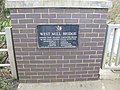 West Mill Bridge - geograph.org.uk - 305992.jpg 640 × 480; 95 KB
-
 Westmill Woodland Burial Site, near Watchfield - geograph.org.uk - 3070376.jpg 4,000 × 3,000; 2.89 MB
-

-
 Bridleway and Rhyne - geograph.org.uk - 105764.jpg 640 × 426; 140 KB
-
 Defence Academy, Shrivenham Campus - geograph.org.uk - 306464.jpg 640 × 480; 57 KB
-

-
 Farm road, Watchfield - geograph.org.uk - 448923.jpg 640 × 480; 151 KB
-
 Farmland and copses, Watchfield - geograph.org.uk - 443879.jpg 640 × 480; 157 KB
-
 Farmland, Watchfield - geograph.org.uk - 443882.jpg 640 × 480; 151 KB
-
 Farmland, Watchfield - geograph.org.uk - 443896.jpg 640 × 480; 172 KB
-
 Field at Southwick - geograph.org.uk - 109433.jpg 640 × 426; 112 KB
-

-
 Footpath to Odstone Farm - geograph.org.uk - 306577.jpg 640 × 480; 157 KB
-
 Gulls in field off Vole Road - geograph.org.uk - 105501.jpg 640 × 426; 100 KB
-
 Main Line - geograph.org.uk - 306573.jpg 640 × 480; 106 KB
-
 Mark Causeway - geograph.org.uk - 105760.jpg 640 × 426; 122 KB
-
 Pretty cottage near Broadleaze Farm - geograph.org.uk - 306567.jpg 640 × 480; 87 KB
-
 Rhyne - geograph.org.uk - 105754.jpg 640 × 426; 134 KB
-
 Stone Farm - geograph.org.uk - 306563.jpg 640 × 480; 66 KB
-
 Sunset near Watchfield - geograph.org.uk - 667366.jpg 640 × 480; 240 KB
-
 Track - geograph.org.uk - 105749.jpg 640 × 426; 149 KB
-
 Track and fields south of Coleshill - geograph.org.uk - 446494.jpg 640 × 480; 130 KB
-
 Waylands - geograph.org.uk - 306569.jpg 640 × 480; 94 KB
-
 Wheat, late May - geograph.org.uk - 446583.jpg 480 × 640; 143 KB


_-_geograph.org.uk_-_6563949.jpg)
_-_geograph.org.uk_-_6563958.jpg)
_-_geograph.org.uk_-_6563993.jpg)
_-_geograph.org.uk_-_6564002.jpg)
_-_geograph.org.uk_-_6564052.jpg)
_-_geograph.org.uk_-_6564006.jpg)
_-_geograph.org.uk_-_6564011.jpg)
_-_geograph.org.uk_-_6564016.jpg)
_-_geograph.org.uk_-_6564017.jpg)
_-_geograph.org.uk_-_6564032.jpg)
_-_geograph.org.uk_-_6564020.jpg)
_-_geograph.org.uk_-_6564058.jpg)
_-_geograph.org.uk_-_6564026.jpg)
_-_geograph.org.uk_-_6564029.jpg)
_-_geograph.org.uk_-_6564035.jpg)
_-_geograph.org.uk_-_6564038.jpg)
_-_geograph.org.uk_-_6564041.jpg)
_-_geograph.org.uk_-_6564043.jpg)
_-_geograph.org.uk_-_6564046.jpg)

_-_geograph.org.uk_-_6564056.jpg)
_-_geograph.org.uk_-_6564062.jpg)
_-_geograph.org.uk_-_6564066.jpg)


.jpg)
.jpg)


