Category:Vulcan Iron Works (Seattle)
Jump to navigation
Jump to search
English: Vulcan Iron Works existed, successively, at at least three locations in Seattle, Washington, U.S.:
- In 1893, File:Sanborn Fire Insurance Map from Seattle, King County, Washington. LOC sanborn09315 003-3.jpg and File:Sanborn Fire Insurance Map from Seattle, King County, Washington. LOC sanborn09315 003-4.jpg it spans between the two pages, spanning West Street (now Western Ave.) about halfway between University and Union Streets.
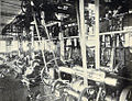
- The 1900 souvenir book Seattle …and the… Orient described it as "located at Fifth Avenue and Lane Street," covering an entire city block roughly at the western edge of what is now Chinatown within Seattle's International District.
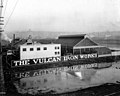
- The 1912 Baist insurance map of Seattle (plate 23) shows it relocated south to what were then the mudflats and is now the Sodo, again occupying an entire block, located between S. Atlantic Street and S. Connecticut Street (now S. Royal Brougham Way) between Fourth and Fifth Avenue South.
Media in category "Vulcan Iron Works (Seattle)"
The following 11 files are in this category, out of 11 total.
-
 Argus - A.Y.P. ed. - Inside cover.jpg 4,726 × 6,716; 4.19 MB
-

-
 Seattle - Vulcan Iron Works 01 - 1900.jpg 987 × 779; 296 KB
-
 Seattle - Vulcan Iron Works 02 - 1900.jpg 1,008 × 771; 790 KB
-
 Seattle and the Orient p104.jpg 1,453 × 2,362; 1.33 MB
-
 Seattle tideflats viewed from Beacon Hill (CURTIS 1691).jpeg 768 × 579; 65 KB
-

-

-

-

-

.jpg)


.jpg)
.jpg)
.jpg)
.jpeg)
.jpeg)
.jpg)