Category:Utah State Route 97
Jump to navigation
Jump to search
 | number: | (ninety-seven) |
|---|---|---|
| State highways in Utah: | 77 · 78 · 79 · 80 · 81 · 82 · 83 · 84 · 85 · 86 · 87 · 88 · 89 · 90 · 91 · 92 · 93 · 94 · 95 · 96 · 97 · 98 · 99 · 100 · 101 · 102 · 103 · 104 · 105 · 106 · 107 · 108 · 109 · 110 · 111 · 112 · 113 · 114 · 115 · 116 · 117 |
state highway in Hooper and Roy in Utah, United States | |||||
| Upload media | |||||
| Instance of | |||||
|---|---|---|---|---|---|
| Location | |||||
| Transport network | |||||
| Connects with | |||||
| Owned by | |||||
| Maintained by | |||||
| Inception |
| ||||
| Length |
| ||||
| Terminus | |||||
| |||||
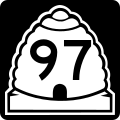
English: Media related to Utah State Route 97, a 5.347-mile (8.605 km) east-west state highway in southwestern Weber County, Utah, United States, that connects Utah State Route 37 (South 5900 West) in Hooper with the Northwest Gate of Hill Air Force Base, and has an interchange with Interstate 15 near the east end of the route.
Subcategories
This category has the following 3 subcategories, out of 3 total.
S
Media in category "Utah State Route 97"
The following 3 files are in this category, out of 3 total.
-
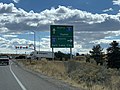 Ogden-SLC (45164453952).jpg 4,032 × 3,024; 2.07 MB
-
 Utah 97.svg 600 × 600; 11 KB
-
 Utah SR 97.svg 385 × 385; 8 KB
.jpg)
