Category:St. Augustine, Florida in the 18th century
Jump to navigation
Jump to search
Subcategories
This category has the following 6 subcategories, out of 6 total.
Media in category "St. Augustine, Florida in the 18th century"
The following 17 files are in this category, out of 17 total.
-
 (1737) Delineatio munimenti et Portus S.AUGUSTINI by Homann Heirs.jpg 1,146 × 1,128; 1.41 MB
-

-

-

-

-

-
 Excerpt from legend of Olano Map.jpg 515 × 504; 146 KB
-
 Governors house.jpg 351 × 236; 40 KB
-
 Plan of St. Augustin in East Florida, 1783.jpg 900 × 641; 229 KB
-
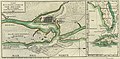
 Plan of Town and Harbour of St. Augustine.jpg 609 × 419; 65 KB
-
 Plano de la Ciudad y Puerto de San Agustin de la Florida (8900730155).jpg 3,000 × 1,983; 6.88 MB
-
 Plano de la ciudad y puerto de San Agustin de la Florida, 1783.jpg 3,910 × 1,922; 5.09 MB
-
 Plano de la ciudad y puerto de San Agustin de la Florida, 1783.tif 4,488 × 2,347; 30.16 MB
-
 St Aug Oglethorpe Park marker01.jpg 3,216 × 4,288; 2.83 MB
-
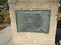 St Aug Oglethorpe Park plaque02.jpg 4,288 × 3,216; 2.86 MB
-
 St. Augustine Harbour, crop of Les principales forteresses, ports etc.jpg 1,036 × 1,046; 213 KB
-
 StAugustine1702Siege.jpg 1,100 × 555; 197 KB
_Delineatio_munimenti_et_Portus_S.AUGUSTINI_by_Homann_Heirs.jpg)


.jpg)


