Category:South Heighton
Jump to navigation
Jump to search
village in the United Kingdom  | |||||
| Upload media | |||||
| Instance of | |||||
|---|---|---|---|---|---|
| Location | Lewes, East Sussex, South East England, England | ||||
| Population |
| ||||
| Area |
| ||||
| official website | |||||
 | |||||
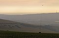
English: South Heighton is a village and civil parish in the Lewes District of East Sussex, England. The village is located seven miles (12 km) south of Lewes. In the 1890s the population of the village grew from less than 100 to over 500 as a result of the opening of a nearby cement manufacturing plant. The village is now associated with the urbanised area of Newhaven.
Subcategories
This category has the following 4 subcategories, out of 4 total.
N
- Norton, East Sussex (8 F)
Media in category "South Heighton"
The following 200 files are in this category, out of 255 total.
(previous page) (next page)-

-
 A passing crop sprayer, Norton Bottom - geograph.org.uk - 4331976.jpg 640 × 480; 133 KB
-
 A26 - geograph.org.uk - 3493267.jpg 640 × 430; 68 KB
-
 A26 out of Newhaven - geograph.org.uk - 4431013.jpg 3,323 × 2,084; 3.48 MB
-
 A26, South Heighton - geograph.org.uk - 1837128.jpg 640 × 430; 50 KB
-
 A26, South Heighton - geograph.org.uk - 2846812.jpg 4,320 × 3,240; 3.76 MB
-
 A26, South Heighton - geograph.org.uk - 4017330.jpg 640 × 379; 55 KB
-
 Access Land boundary fence - geograph.org.uk - 2902112.jpg 4,000 × 3,000; 3.56 MB
-
 Access Land near Stump Bottom - geograph.org.uk - 2902024.jpg 4,000 × 3,000; 3.49 MB
-
 Allotments, South Heighton - geograph.org.uk - 123533.jpg 640 × 479; 159 KB
-
 Ashen Tree Brook - geograph.org.uk - 2667597.jpg 640 × 480; 78 KB
-
 Avis Rd off A26 - geograph.org.uk - 2371320.jpg 640 × 430; 48 KB
-
 Bishopstone Road - geograph.org.uk - 2500929.jpg 640 × 480; 179 KB
-
 Bishopstone Road - geograph.org.uk - 3109521.jpg 480 × 640; 57 KB
-
 Bishopstone Road pumping station - geograph.org.uk - 2500930.jpg 640 × 480; 159 KB
-
 Blackcap Hill - geograph.org.uk - 2668844.jpg 640 × 480; 92 KB
-
 Blossom and Gorse on Access Land - geograph.org.uk - 2901999.jpg 4,000 × 3,000; 3.59 MB
-
 Bow Field - geograph.org.uk - 3108876.jpg 640 × 480; 86 KB
-
 Bridleway across rape field - geograph.org.uk - 3490781.jpg 640 × 480; 120 KB
-
 Bridleway from South Heighton - geograph.org.uk - 2624570.jpg 11,057 × 2,100; 7.31 MB
-
 Bridleway from South Heighton - geograph.org.uk - 2627780.jpg 640 × 480; 95 KB
-
 Bridleway gate and farm gate on Heighton Hill - geograph.org.uk - 2979317.jpg 4,000 × 3,000; 4.34 MB
-
 Bridleway Junction - geograph.org.uk - 1172764.jpg 640 × 480; 105 KB
-
 Bridleway junction - geograph.org.uk - 2501631.jpg 640 × 480; 151 KB
-
 Bridleway junction on the outskirts of Denton - geograph.org.uk - 2979378.jpg 4,000 × 3,000; 3.52 MB
-
 Bridleway on Heighton Hill - geograph.org.uk - 2902119.jpg 4,000 × 3,000; 3.55 MB
-
 Bridleway rising through Stump Bottom - geograph.org.uk - 2979366.jpg 4,000 × 3,000; 3.62 MB
-
 Bridleway to Beddingham Hill - geograph.org.uk - 2630821.jpg 640 × 480; 77 KB
-
 Bridleway to Beddingham Hill - geograph.org.uk - 2630828.jpg 640 × 480; 92 KB
-
 Bridleway to Beddington Hill - geograph.org.uk - 2627789.jpg 640 × 480; 93 KB
-
 Bridleway to Blackcap Farm - geograph.org.uk - 2668836.jpg 640 × 480; 104 KB
-
 Bridleway to Blackcap Hill - geograph.org.uk - 2902008.jpg 4,000 × 3,000; 3.49 MB
-
 Bridleway to Bostal Hill - geograph.org.uk - 2105296.jpg 640 × 427; 74 KB
-
 Bridleway to Bostal Hill - geograph.org.uk - 2966221.jpg 640 × 480; 130 KB
-
 Bridleway to Pumping Station in Norton Bottom - geograph.org.uk - 2979502.jpg 4,000 × 3,000; 3.58 MB
-
 Bridleway towards Alciston - geograph.org.uk - 2501633.jpg 640 × 480; 174 KB
-
 Bridleway towards Glynde - geograph.org.uk - 2502383.jpg 640 × 480; 161 KB
-
 Bridleway towards Poverty Bottom - geograph.org.uk - 3491071.jpg 640 × 480; 146 KB
-

-
 Chalk Pit Brook-Smoak Hall - geograph.org.uk - 2667626.jpg 640 × 480; 77 KB
-

-
 Cockshart Bank - geograph.org.uk - 2668780.jpg 640 × 482; 83 KB
-
 Cornfield at Norton - geograph.org.uk - 2503583.jpg 640 × 480; 81 KB
-
 Cottages, South Heighton - geograph.org.uk - 2716863.jpg 640 × 480; 139 KB
-
 Cows near Norton - geograph.org.uk - 2503582.jpg 640 × 480; 150 KB
-
 Cows on South Downs - geograph.org.uk - 2105290.jpg 640 × 427; 82 KB
-
 Cows on the South Downs - geograph.org.uk - 2118865.jpg 640 × 427; 74 KB
-
 Denton Laine - geograph.org.uk - 3109297.jpg 640 × 480; 92 KB
-
 Devilsrest Bottom - geograph.org.uk - 3100571.jpg 480 × 640; 78 KB
-
 Devilsrest Bottom - geograph.org.uk - 3100577.jpg 640 × 480; 74 KB
-
 Devilsrest Bottom - geograph.org.uk - 3109274.jpg 640 × 480; 77 KB
-
 Devilsrest Bottom towards Norton. - geograph.org.uk - 1092209.jpg 640 × 432; 80 KB
-

-

-
 Disused Chalk Pit, Norton Hill - geograph.org.uk - 3102330.jpg 640 × 480; 79 KB
-
 Downland arable farming - geograph.org.uk - 2900239.jpg 4,000 × 3,000; 3.26 MB
-
 Dry Dew Pond on Heighton Hill - geograph.org.uk - 2902123.jpg 4,000 × 3,000; 3.57 MB
-
 Earthen field rising to Norton Top - geograph.org.uk - 2396298.jpg 1,500 × 1,125; 1.73 MB
-
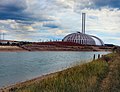 Energy from Waste facility - Newhaven - geograph.org.uk - 2519863.jpg 1,600 × 1,233; 370 KB
-
 Farm Track, Norton - geograph.org.uk - 3100561.jpg 480 × 640; 91 KB
-
 Farmland near Denton - geograph.org.uk - 2504026.jpg 640 × 204; 46 KB
-
 Farmland near Denton - geograph.org.uk - 2504052.jpg 640 × 480; 182 KB
-
 Farmland near Denton - geograph.org.uk - 2504056.jpg 640 × 480; 126 KB
-
 Farmland north of South Heighton - geograph.org.uk - 2624581.jpg 640 × 427; 86 KB
-
 Farmyard at Manor Farm - geograph.org.uk - 2900167.jpg 4,000 × 3,000; 3.48 MB
-
 Feeding Time, Poverty Bottom - geograph.org.uk - 1172786.jpg 640 × 480; 77 KB
-
 Field at Devilsrest Bottom, Norton - geograph.org.uk - 1092223.jpg 640 × 454; 92 KB
-

-
 Footpath from Denton to Bishopstone - geograph.org.uk - 3543283.jpg 640 × 480; 139 KB
-
 Footpath from the north end of Norton - geograph.org.uk - 2975327.jpg 4,000 × 3,000; 3.22 MB
-
 Footpath South Heighton 32 climbing east from Norton - geograph.org.uk - 2975342.jpg 4,000 × 3,000; 3.55 MB
-
 Footpath to Denton - geograph.org.uk - 1173972.jpg 640 × 480; 77 KB
-
 Footpath to Seaford Road - geograph.org.uk - 2502490.jpg 640 × 480; 95 KB
-

-

-
 Fore Hill towards Seaford - geograph.org.uk - 1137801.jpg 640 × 465; 93 KB
-
 Gardener's Hill - geograph.org.uk - 2668818.jpg 480 × 640; 81 KB
-
 Gardener's Hill - geograph.org.uk - 2668831.jpg 640 × 480; 103 KB
-
 Gate at Bridleway and track junction - geograph.org.uk - 2901978.jpg 4,000 × 3,000; 3.38 MB
-
 Gate on South Downs - geograph.org.uk - 2105268.jpg 640 × 480; 89 KB
-
 Gate on the path - and view to the SSW - geograph.org.uk - 6519895.jpg 1,632 × 918; 662 KB
-

-
 Gates on Heighton Hill - geograph.org.uk - 3490707.jpg 640 × 480; 88 KB
-
 Grass triangle on Bishopstone Road at Norton - geograph.org.uk - 2975296.jpg 4,000 × 3,000; 3.51 MB
-
 Ham Laine - geograph.org.uk - 3102326.jpg 640 × 480; 61 KB
-
 Hawth Furlong - geograph.org.uk - 3100545.jpg 640 × 480; 70 KB
-
 Hay bales on Fore Hill near Newhaven - geograph.org.uk - 3752797.jpg 768 × 1,024; 179 KB
-
 Hazy view from Heighton Hill - geograph.org.uk - 2979336.jpg 4,000 × 3,000; 3.85 MB
-

-
 Heighton Road near its junction with the A26 - geograph.org.uk - 2900146.jpg 4,000 × 3,000; 3.27 MB
-
 Heighton Road South Heighton - geograph.org.uk - 2900176.jpg 4,000 × 3,000; 3.48 MB
-
 Herd on the move on Heighton Hill - geograph.org.uk - 2979290.jpg 4,000 × 3,000; 4.31 MB
-
 Home Bottom - geograph.org.uk - 1172744.jpg 640 × 480; 71 KB
-
 Home Bottom - geograph.org.uk - 2668840.jpg 640 × 480; 75 KB
-
 Home Bottom from Fore Hill - geograph.org.uk - 1137861.jpg 640 × 434; 132 KB
-
 Home Bottom from Fore Hill - geograph.org.uk - 1137866.jpg 640 × 363; 96 KB
-
 Home Laine - geograph.org.uk - 3100569.jpg 640 × 479; 100 KB
-
 Industrial units at The Hollow - geograph.org.uk - 2908085.jpg 4,000 × 3,000; 3.52 MB
-
 Iveagh Crescent - geograph.org.uk - 1177067.jpg 480 × 640; 63 KB
-
 Iveagh Crescent - geograph.org.uk - 2667577.jpg 640 × 480; 73 KB
-
 Land near South Heighton Farm - geograph.org.uk - 2627777.jpg 640 × 480; 77 KB
-
 Lewes-Seaford Railway - geograph.org.uk - 2665693.jpg 480 × 640; 89 KB
-
 Line of Trees, Blackcap Hill - geograph.org.uk - 1172737.jpg 640 × 480; 77 KB
-
 Looking Down on Norton - geograph.org.uk - 1173899.jpg 640 × 480; 60 KB
-
 Looking Down to Heighton Farm - geograph.org.uk - 1177101.jpg 640 × 480; 85 KB
-

-
 Looking south over the River Ouse valley - geograph.org.uk - 2908068.jpg 4,000 × 3,000; 3.41 MB
-
 Meadow at Norton - geograph.org.uk - 2503584.jpg 640 × 480; 124 KB
-
 New Barn - geograph.org.uk - 1177106.jpg 640 × 480; 89 KB
-
 New Road, South Heighton - geograph.org.uk - 2600571.jpg 1,600 × 1,200; 557 KB
-
 New water works building - geograph.org.uk - 2979515.jpg 4,000 × 3,000; 3.76 MB
-
 Newhaven Incinerator - geograph.org.uk - 2665681.jpg 480 × 640; 92 KB
-
 Newhaven seen from Gardener’s Hill - geograph.org.uk - 4332487.jpg 640 × 480; 64 KB
-
 North Barn - geograph.org.uk - 3109264.jpg 640 × 480; 90 KB
-
 North Furlong - geograph.org.uk - 2667669.jpg 640 × 480; 75 KB
-
 North Furlong - geograph.org.uk - 3100549.jpg 640 × 480; 78 KB
-
 Norton - geograph.org.uk - 3102317.jpg 640 × 480; 63 KB
-
 Norton - geograph.org.uk - 3108881.jpg 640 × 480; 122 KB
-
 Norton Bottom - geograph.org.uk - 1172843.jpg 640 × 480; 90 KB
-
 Norton Bottom - geograph.org.uk - 3109291.jpg 480 × 640; 65 KB
-

-
 Norton Bottom near Bishopstone - geograph.org.uk - 881243.jpg 640 × 480; 132 KB
-

-
 Norton Cottage - geograph.org.uk - 3109246.jpg 480 × 640; 91 KB
-
 Norton Hill - geograph.org.uk - 1173907.jpg 640 × 480; 57 KB
-
 Norton Hill - geograph.org.uk - 3100550.jpg 640 × 480; 68 KB
-
 Norton Hill - geograph.org.uk - 3102320.jpg 640 × 480; 70 KB
-
 Norton Top Laine (1) - geograph.org.uk - 3100574.jpg 640 × 471; 89 KB
-
 Norton Top Laine (2) - geograph.org.uk - 3100580.jpg 640 × 480; 67 KB
-
 Norton Village, near Bishopstone - geograph.org.uk - 1528007.jpg 640 × 481; 69 KB
-
 Norton, Bishopstone, East Sussex - geograph.org.uk - 4036324.jpg 1,600 × 900; 432 KB
-
 Old chalk quarry - geograph.org.uk - 2627781.jpg 640 × 480; 73 KB
-
 Old Course of River Ouse - geograph.org.uk - 2665641.jpg 640 × 480; 84 KB
-
 Old Forge, Heighton Road - geograph.org.uk - 1177096.jpg 480 × 640; 116 KB
-
 Overgrown path on Gardener's Hill - geograph.org.uk - 2979352.jpg 4,000 × 3,000; 3.53 MB
-
 Overgrown sidings, Newhaven - geograph.org.uk - 123547.jpg 640 × 479; 185 KB
-
 Page's New Barn - geograph.org.uk - 1178764.jpg 640 × 480; 146 KB
-
 Page's New Barn - geograph.org.uk - 2624632.jpg 640 × 480; 121 KB
-
 Page's New Barn - geograph.org.uk - 2900230.jpg 4,000 × 3,000; 3.47 MB
-
 Page's New Barn, South Heighton. - geograph.org.uk - 1139331.jpg 640 × 300; 62 KB
-
 Parallel ditches - geograph.org.uk - 4030835.jpg 640 × 430; 50 KB
-
 Parish Boundary, Blackcap Hill - geograph.org.uk - 1172727.jpg 640 × 480; 73 KB
-
 Parish Boundary, Blackcap Hill - geograph.org.uk - 2668850.jpg 480 × 640; 199 KB
-
 Path heading from Home Bottom to Stump Bottom - geograph.org.uk - 6515285.jpg 1,633 × 918; 540 KB
-
 Path heading north towards Snap Hill - geograph.org.uk - 6515299.jpg 1,633 × 918; 605 KB
-
 Path heading south from Snap Hill - geograph.org.uk - 6515307.jpg 1,632 × 918; 709 KB
-
 Path heading SW towards Stump Bottom - geograph.org.uk - 6515286.jpg 4,029 × 2,266; 2.76 MB
-
 Path leading NW from Fore Hill, near Newhaven - geograph.org.uk - 3752799.jpg 768 × 1,024; 195 KB
-
 Path on the ridge above Home Bottom and Stump Bottom - geograph.org.uk - 2901988.jpg 4,000 × 3,000; 3.44 MB
-
 Pheromone Trap, Norton Bottom - geograph.org.uk - 3109284.jpg 480 × 640; 193 KB
-
 Pit Brook - geograph.org.uk - 2667603.jpg 640 × 480; 87 KB
-
 Pond at Norton - geograph.org.uk - 2503586.jpg 640 × 480; 102 KB
-
 Poppies by Bishopstone Road - geograph.org.uk - 2504556.jpg 640 × 480; 209 KB
-
 Poppies by the track heading towards Stump Bottom - geograph.org.uk - 6515292.jpg 4,029 × 2,266; 3.1 MB
-
 Pottery and postbox by the bus stop on Heighton Road - geograph.org.uk - 2900160.jpg 4,000 × 3,000; 3.45 MB
-
 Poulton Engineering Ltd - geograph.org.uk - 2667647.jpg 640 × 480; 101 KB
-
 Poverty Bottom - geograph.org.uk - 1172781.jpg 640 × 480; 87 KB
-
 Poverty Bottom - geograph.org.uk - 1173817.jpg 640 × 480; 82 KB
-
 Poverty Bottom - geograph.org.uk - 2613622.jpg 3,968 × 2,976; 2.62 MB
-
 Poverty Bottom Pumping Station - geograph.org.uk - 1172837.jpg 480 × 640; 95 KB
-

-
 Pumping house at Pumping Station - geograph.org.uk - 2979511.jpg 4,000 × 3,000; 4 MB
-

-
 Pumping station, Norton Bottom - geograph.org.uk - 3491063.jpg 640 × 480; 94 KB
-
 Pumping station, Norton Bottom - geograph.org.uk - 4331994.jpg 640 × 427; 79 KB
-
 Pylon in the Ouse Valley - geograph.org.uk - 1837116.jpg 640 × 430; 28 KB
-
 Rabbit warren on Heighton Hill - geograph.org.uk - 3490752.jpg 640 × 480; 135 KB
-
 Rede Gate Brook - geograph.org.uk - 2667619.jpg 640 × 480; 68 KB
-
 Restricted Byway north to Beddingham Hill - geograph.org.uk - 2900207.jpg 4,000 × 3,000; 3.39 MB
-
 Road towards Norton Bottom - geograph.org.uk - 4036326.jpg 1,600 × 1,076; 477 KB
-
 Rookery Furlong - geograph.org.uk - 3102335.jpg 640 × 480; 93 KB
-
 Rookery Hill - geograph.org.uk - 3100554.jpg 640 × 480; 71 KB
-
 Row of Cottages by the A26 - geograph.org.uk - 2371317.jpg 640 × 294; 59 KB
-
 Row of trees south of Blackcap Hill - geograph.org.uk - 6515283.jpg 4,002 × 1,949; 2.31 MB
-
 Ruin, The Halls - geograph.org.uk - 2665667.jpg 640 × 480; 85 KB
-
 SCA Recycling - geograph.org.uk - 2667653.jpg 640 × 480; 80 KB
-

-
 Short Drove Brook - geograph.org.uk - 2667617.jpg 480 × 640; 85 KB
-
 Signpost decorated with flowers - on Snap Hill - geograph.org.uk - 6515313.jpg 3,024 × 3,024; 3.16 MB
-
 Snap Hill - geograph.org.uk - 1172753.jpg 640 × 480; 49 KB
-
 Snap Hill - geograph.org.uk - 1172769.jpg 640 × 480; 95 KB
-
 Snap Hill - geograph.org.uk - 1178770.jpg 640 × 480; 83 KB
-
 Snap Hill - geograph.org.uk - 2668823.jpg 640 × 480; 79 KB
-
 Snap Hill above South Heighton - geograph.org.uk - 1139313.jpg 640 × 480; 107 KB
-
 Snap Hill above South Heighton - geograph.org.uk - 1139323.jpg 640 × 447; 92 KB
-
 Snap Hill seen from Poverty Bottom - geograph.org.uk - 4332330.jpg 640 × 480; 76 KB
-
 South Downs - geograph.org.uk - 2118864.jpg 640 × 427; 77 KB
-
 South Downs - geograph.org.uk - 2118939.jpg 640 × 427; 88 KB
-
 South Downs farmland - geograph.org.uk - 2630833.jpg 640 × 320; 57 KB
-
 South Heighton - geograph.org.uk - 2900184.jpg 4,000 × 3,000; 3.35 MB
-
 South Heighton from Fore Hill - geograph.org.uk - 1137679.jpg 640 × 416; 51 KB
-
 South Heighton Recreation Ground - geograph.org.uk - 2667665.jpg 640 × 480; 64 KB
-
 South Heighton Turnoff, A26 - geograph.org.uk - 2371308.jpg 640 × 308; 41 KB
-
 South Heighton Village Hall - geograph.org.uk - 2908099.jpg 4,000 × 3,000; 3.41 MB
-
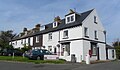 South View Terrace, South Heighton (September 2011).JPG 2,400 × 1,400; 1.01 MB
-
 Southview Terrace - geograph.org.uk - 1177081.jpg 640 × 480; 96 KB
-
 Stone memorial seat by the path to Beddingham Hill - geograph.org.uk - 2900246.jpg 4,000 × 3,000; 3.46 MB
-
 Stump Bottom - geograph.org.uk - 1172756.jpg 640 × 480; 76 KB
-
 Stump Bottom - geograph.org.uk - 2668827.jpg 640 × 480; 75 KB
-


_-_geograph.org.uk_-_3100574.jpg)
_-_geograph.org.uk_-_3100580.jpg)


.JPG)


