Category:Shubert's maps of Bessarabia Governorate
Jump to navigation
Jump to search
Media in category "Shubert's maps of Bessarabia Governorate"
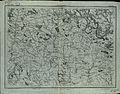
The following 22 files are in this category, out of 22 total.
-
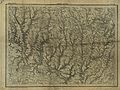 Shubert map - R26L06.jpg 7,651 × 5,760; 16.61 MB
-
 Shubert map - R27L04.jpg 7,750 × 5,920; 15.89 MB
-
 Shubert map - R27L05.jpg 7,849 × 6,034; 13.33 MB
-
 Shubert map - R27L06.jpg 7,757 × 6,058; 14.25 MB
-
 Shubert map - R27L07.jpg 7,206 × 5,508; 6.16 MB
-
 Shubert map - R28L05.jpg 7,957 × 6,096; 16.63 MB
-
 Shubert map - R28L06.jpg 7,688 × 6,034; 14.95 MB
-
 Shubert map - R28L07.jpg 7,619 × 6,026; 16.8 MB
-
 Shubert map - R29L06.jpg 7,696 × 6,019; 14.72 MB
-
 Shubert map - R29L07.jpg 7,691 × 5,783; 17.92 MB
-
 Shubert map - R30L07.jpg 7,870 × 5,989; 17.02 MB
-
 Shubert map - R30L08.jpg 7,478 × 5,578; 15.47 MB
-
 Shubert map - R31L06.jpg 4,640 × 3,568; 4.33 MB
-
 Shubert map - R31L07.jpg 7,430 × 5,752; 16.04 MB
-
 Shubert map - R31L08.jpg 7,469 × 5,823; 14.08 MB
-
 Shubert map - R31L09.jpg 7,752 × 5,961; 11.32 MB
-
 Shubert map - R32L07.jpg 4,495 × 3,499; 6.26 MB
-
 Shubert map - R32L08.jpg 4,591 × 3,576; 5.47 MB
-
 Shubert map - R32L09.jpg 7,734 × 5,804; 15.21 MB
-
 Shubert map - R33L06.jpg 7,979 × 6,000; 16.18 MB
-
 Shubert map - R33L07.jpg 7,308 × 5,652; 9.16 MB
-
 Shubert map - R33L08.jpg 7,466 × 5,850; 15.92 MB


