Category:Satellite pictures of the Otago Region
Jump to navigation
Jump to search
Media in category "Satellite pictures of the Otago Region"
The following 75 files are in this category, out of 75 total.
-
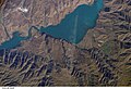 Aviemore Dam and lake, New Zealand, looking south (ISS014-E-18948).jpg 3,032 × 2,064; 1.08 MB
-
 Blackhead and Kaikorai Stream, New Zealand (ISS016-E-12989).jpg 3,032 × 2,008; 1.02 MB
-
 Cape Saunders, New Zealand, looking southeast (ISS018-E-7783).jpg 3,072 × 2,040; 402 KB
-
 Crop of blizzard NASA photo of Southern South Island.jpg 1,417 × 1,042; 451 KB
-
 Dunedin and Otago Peninsula, New Zealand, looking northeast (ISS016-E-12674).jpg 3,032 × 2,008; 867 KB
-
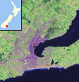
 Dunedin area New Zealand.jpg 481 × 477; 70 KB
-
 Dunedin city urban area no inset.png 1,748 × 1,813; 607 KB
-
 Dunedin Otago Peninsula Harbour.jpg 800 × 593; 120 KB
-
 Dunedin, New Zealand location map.PNG 421 × 436; 236 KB
-
 Dunedin, New Zealand, looking northeast (ISS016-E-12675).jpg 3,032 × 2,008; 949 KB
-
 Dunedin, New Zealand, looking northeast (ISS016-E-12676).jpg 3,032 × 2,008; 931 KB
-
 Dunedin, New Zealand, looking southeast (ISS018-E-7786).jpg 3,072 × 2,040; 523 KB
-
 Dunedin, New Zealand, looking southeast (ISS018-E-7787).jpg 3,072 × 2,040; 459 KB
-
 Dunedin, Otago Peninsula and Harbour, New Zealand, looking south (ISS021-E-24606).jpg 3,072 × 2,040; 484 KB
-
 Dunedin, Otago Peninsula and Harbour, New Zealand, looking south (ISS021-E-24607).jpg 3,072 × 2,040; 459 KB
-
 DunedinSatmap.png 440 × 441; 331 KB
-
 Frankton and Queenstown, New Zealand (ISS016-E-15268).jpg 3,032 × 2,008; 1.14 MB
-
 Frankton and Queenstown, New Zealand (ISS016-E-15269).jpg 3,032 × 2,008; 1.16 MB
-
 Glendhu Bay and Wanaka town, Lake Wanaka, New Zealand (ISS014-E-18941).jpg 3,032 × 2,064; 1,020 KB
-

-
 Hawea and Lake Hawea, New Zealand (ISS016-E-12655).jpg 3,032 × 2,008; 1.42 MB
-
 Hollyford Valley and upper Lake Wakatipu, New Zealand (ISS017-E-10658).jpg 3,072 × 2,040; 928 KB
-
 ISS Waitaki River, Canterbury and Otago.jpg 1,024 × 672; 160 KB
-
 Kaitangata and Otago coast, New Zealand, looking south (ISS014-E-18564).jpg 3,032 × 2,064; 995 KB
-
 Kaka Point and Catlins Coast, New Zealand, looking south (ISS014-E-18565).jpg 3,032 × 2,064; 895 KB
-
 Lake Hawea (township and lake), New Zealand, looking east (ISS018-E-7772).jpg 3,072 × 2,040; 412 KB
-
 Lake Hawea (township and lake), New Zealand, looking east (ISS018-E-7773).jpg 3,072 × 2,040; 401 KB
-
 Lake Hawea (township and lake), New Zealand, looking southeast (ISS018-E-7774).jpg 3,072 × 2,040; 419 KB
-
 Lake Hawea and Dingle Burn, New Zealand, looking east (ISS016-E-12657).jpg 3,032 × 2,008; 1.33 MB
-
 Lake Hawea, New Zealand, looking east (ISS016-E-12656).jpg 3,032 × 2,008; 1.11 MB
-
 Lake Wakatipu (northern arm), New Zealand, looking southeast (ISS016-E-12968).jpg 3,032 × 2,008; 1.4 MB
-
 Lake Wakatipu (southern arm), New Zealand, looking southeast (ISS016-E-12971).jpg 3,032 × 2,008; 1.39 MB
-
 Lake Wakatipu and Queenstown, New Zealand, looking southeast (ISS016-E-12969).jpg 3,032 × 2,008; 1.29 MB
-
 Lake Wakatipu and Queenstown, New Zealand, looking southeast (ISS016-E-12970).jpg 3,032 × 2,008; 1.32 MB
-
 Lake Wakatipu, New Zealand (ISS017-E-10659).jpg 3,072 × 2,040; 883 KB
-
 Lake Wakatipu, New Zealand, looking southeast (ISS030-E-7700).jpg 4,288 × 2,848; 1.4 MB
-
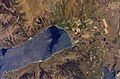
 Lake Wanaka, New Zealand (ISS014-E-18940).jpg 3,032 × 2,064; 887 KB
-
 Lakes Hawea and Wanaka, New Zealand, looking east (ISS016-E-12973).jpg 3,032 × 2,008; 1.08 MB
-
 Lakes Hawea and Wanaka, New Zealand, looking east (ISS021-E-24602).jpg 3,072 × 2,040; 940 KB
-
 Lakes Hawea and Wanaka, New Zealand, looking south (ISS014-E-18942).jpg 3,032 × 2,064; 1.12 MB
-
 Lakes Wanaka and Hawea, New Zealand, looking west (ISS046-E-31060).jpg 4,928 × 3,280; 2.23 MB
-
 Macraes Gold Mine (Satellite Image).jpg 1,014 × 768; 653 KB
-
 Mount Brewster and Hunter River, New Zealand, looking east (ISS016-E-12659).jpg 3,032 × 2,008; 1.22 MB
-
 Mouth of Otago Harbour, New Zealand, looking northeast (ISS016-E-12677).jpg 3,032 × 2,008; 955 KB
-
 Mouths of Dingle Burn and Terrace Creek, Lake Hawea, New Zealand (ISS014-E-18563).jpg 3,032 × 2,064; 1.41 MB
-
 NASA-SLakes.png 289 × 263; 57 KB
-
 Otago Harbour and Peninsula, New Zealand (ISS041-E-64220).jpg 4,256 × 2,832; 1.02 MB
-
 Otago Harbour and Peninsula, New Zealand (ISS041-E-64221).jpg 4,256 × 2,832; 1,002 KB
-
 Otago Harbour and Peninsula, New Zealand (ISS041-E-64222).jpg 4,256 × 2,832; 1.04 MB
-
 Otago Harbour and Peninsula, New Zealand (ISS041-E-64224).jpg 4,256 × 2,832; 1.05 MB
-
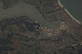
 Otago harbour landsat crop.jpg 417 × 455; 29 KB
-
 Otago harbour landsat.jpg 800 × 593; 59 KB
-
 Otago Peninsula and Harbour, New Zealand, looking east (ISS021-E-24605).jpg 3,072 × 2,040; 382 KB
-
 Otago Peninsula, New Zealand, looking northeast (ISS016-E-12673).jpg 3,032 × 2,008; 856 KB
-
 Port Chalmers and Otago Harbour, New Zealand, looking southeast (ISS018-E-7784).jpg 3,072 × 2,040; 381 KB
-
 Port Chalmers and Otago Harbour, New Zealand, looking southeast (ISS018-E-7785).jpg 3,072 × 2,040; 388 KB
-
 Queenstown and the Frankton Arm of Lake Wakatipu, New Zealand (ISS016-E-12988).jpg 3,032 × 2,008; 1.08 MB
-
 Queenstown, New Zealand, looking east (ISS016-E-12985).jpg 3,032 × 2,008; 1.16 MB
-
 Queenstown, New Zealand, looking east (ISS016-E-12986).jpg 3,032 × 2,008; 1.18 MB
-
 Queenstown, New Zealand, looking east (ISS016-E-12987).jpg 3,032 × 2,008; 1.08 MB
-
 Queenstown, New Zealand, looking south (ISS016-E-24569).jpg 3,032 × 2,008; 931 KB
-
 Queenstown, New Zealand, looking south (ISS016-E-24570).jpg 3,032 × 2,008; 968 KB
-
 Queenstown, New Zealand, looking south (ISS016-E-24571).jpg 3,032 × 2,008; 1,007 KB
-
 Queenstown, New Zealand, looking southeast (ISS016-E-15270).jpg 3,032 × 2,008; 1.11 MB
-
 Queenstown, New Zealand, looking southeast (ISS016-E-15271).jpg 3,032 × 2,008; 1.08 MB
-
 Southern Alps from Lake Wakatipu to Lake Tekapo, New Zealand (ISS017-E-10675).jpg 3,072 × 2,040; 1.04 MB
-
 Southern South Island, New Zealand, looking east (ISS016-E-25880).jpg 3,032 × 2,008; 1.27 MB
-
 Southern South Island, New Zealand, looking east (ISS016-E-25881).jpg 3,032 × 2,008; 1.18 MB
-

-
 The Catlins.jpg 392 × 309; 30 KB
-
 Timaru River, New Zealand, looking south (ISS014-E-18943).jpg 3,032 × 2,064; 996 KB
-
 Wanaka, New Zealand, looking east (ISS018-E-44066).jpg 3,072 × 2,040; 653 KB
-
 Wanaka, New Zealand, looking east (ISS018-E-44067).jpg 3,072 × 2,040; 612 KB
-
 Wanaka, New Zealand, looking east (ISS018-E-44068).jpg 3,072 × 2,040; 643 KB
-
 Wanaka, New Zealand, looking east (ISS018-E-44069).jpg 3,072 × 2,040; 641 KB
.jpg)
.jpg)
.jpg)

.jpg)


.jpg)
.jpg)
.jpg)
.jpg)
.jpg)
.jpg)

.jpg)
.jpg)
.jpg)
.jpg)
.jpg)
.jpg)

.jpg)
.jpg)
,_New_Zealand,_looking_east_(ISS018-E-7772).jpg)
,_New_Zealand,_looking_east_(ISS018-E-7773).jpg)
,_New_Zealand,_looking_southeast_(ISS018-E-7774).jpg)
.jpg)
.jpg)
,_New_Zealand,_looking_southeast_(ISS016-E-12968).jpg)
,_New_Zealand,_looking_southeast_(ISS016-E-12971).jpg)
.jpg)
.jpg)
.jpg)
.jpg)
.jpg)
.jpg)
.jpg)
.jpg)
.jpg)
.jpg)
.jpg)
.jpg)
.jpg)

.jpg)
.jpg)
.jpg)
.jpg)


.jpg)
.jpg)
.jpg)
.jpg)
.jpg)
.jpg)
.jpg)
.jpg)
.jpg)
.jpg)
.jpg)
.jpg)
.jpg)
.jpg)
.jpg)
.jpg)
.jpg)

.jpg)
.jpg)
.jpg)
.jpg)
.jpg)