Category:SVG locator maps of districts of Gladbeck
Jump to navigation
Jump to search
Media in category "SVG locator maps of districts of Gladbeck"
The following 7 files are in this category, out of 7 total.
-
 Karte Gladbecker Stadtteil Brauck.svg 1,041 × 1,116; 33.28 MB
-
 Karte Gladbecker Stadtteil Butendorf.svg 1,041 × 1,116; 33.27 MB
-
 Karte Gladbecker Stadtteil Ellinghorst.svg 1,041 × 1,116; 33.27 MB
-
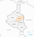 Karte Gladbecker Stadtteil Mitte.svg 1,041 × 1,116; 33.27 MB
-
 Karte Gladbecker Stadtteil Rentfort.svg 1,041 × 1,116; 33.27 MB
-
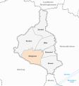
 Karte Gladbecker Stadtteil Zweckel.svg 1,041 × 1,116; 33.27 MB
-
 Karte Gladbecker Stadtteile.svg 1,041 × 1,116; 33.92 MB


