Category:Rodezand 11, Oudewater
Jump to navigation
Jump to search
| Object location | | View all coordinates using: OpenStreetMap |
|---|
 | |||||
| Upload media | |||||
| Instance of |
| ||||
|---|---|---|---|---|---|
| Location | Oudewater, Utrecht, Netherlands | ||||
| Street address |
| ||||
| Located on street | |||||
| Heritage designation |
| ||||
 | |||||
|
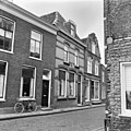
This is a category about rijksmonument number 32078
|
| Address |
|
Media in category "Rodezand 11, Oudewater"
The following 4 files are in this category, out of 4 total.
-
 Aanzicht - Oudewater - 20180016 - RCE.jpg 1,181 × 1,200; 304 KB
-
 Aanzicht - Oudewater - 20180019 - RCE.jpg 1,200 × 1,200; 355 KB
-
 RM32078 Oudewater - Rodezand 11.jpg 1,944 × 2,592; 1.25 MB
-
 Voorgevel - Oudewater - 20180020 - RCE.jpg 810 × 1,200; 211 KB


