Category:River Idle
Jump to navigation
Jump to search

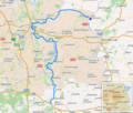
river in the United Kingdom  .png) | |||||
| Upload media | |||||
| Instance of | |||||
|---|---|---|---|---|---|
| Location |
| ||||
| Length |
| ||||
| Mouth of the watercourse | |||||
| Tributary | |||||
 | |||||
Subcategories
This category has the following 7 subcategories, out of 7 total.
B
- Bawtry Bridge (4 F)
- Bawtry Viaduct (8 F)
R
- River Idle Washlands (8 F)
- River Idle, Retford (13 F)
T
W
- West Stockwith Pumping Station (14 F)
Media in category "River Idle"
The following 93 files are in this category, out of 93 total.
-
 And emerging out of the trees - panoramio.jpg 4,608 × 3,456; 5.88 MB
-
 And further north still... - panoramio.jpg 4,608 × 3,456; 6.1 MB
-
 And heading toward the wood - panoramio.jpg 4,608 × 3,456; 6.31 MB
-
 Another shot of the weir - panoramio.jpg 4,608 × 3,456; 6.14 MB
-
 Bailey bridge across River Idle. - geograph.org.uk - 528987.jpg 640 × 378; 109 KB
-
 Bend in the River Idle - panoramio (1).jpg 4,608 × 3,456; 6.13 MB
-
 Bend in the River Idle - panoramio.jpg 4,608 × 3,456; 6 MB
-
 Bridge across the River Idle - looking north - panoramio.jpg 4,608 × 3,456; 6.15 MB
-
 Bridge over the River Idle - geograph.org.uk - 80807.jpg 640 × 482; 129 KB
-
 By The River Idle - near Newington Farm - geograph.org.uk - 4863578.jpg 5,049 × 3,748; 3.85 MB
-
 Close-up in-between the trees - panoramio.jpg 4,608 × 3,456; 6.07 MB
-
 Close-up of the weir - panoramio.jpg 4,608 × 3,456; 5.73 MB
-
 Closer look at the weir - panoramio.jpg 4,608 × 3,456; 5.93 MB
-
 Continuing forward along the River Idle - panoramio.jpg 4,608 × 3,456; 6.06 MB
-
 Fish in the River Idle - panoramio.jpg 4,608 × 3,456; 6.09 MB
-
 Footpath and river in unison - panoramio.jpg 4,608 × 3,456; 6.17 MB
-
 Going north around the River Idle - panoramio.jpg 4,608 × 3,456; 6.23 MB
-
 Guess what is at the end of River Lane^ - geograph.org.uk - 528958.jpg 640 × 381; 107 KB
-
 Haxey Gate Bridge - geograph.org.uk - 3941993.jpg 5,184 × 3,456; 4.16 MB
-
 Heading down the river - panoramio.jpg 4,608 × 3,456; 5.79 MB
-
 Heading north along the river - panoramio.jpg 4,608 × 3,456; 6.25 MB
-
 Heading west round the bend - panoramio.jpg 4,608 × 3,456; 6 MB
-
 Idle (rivière).png 669 × 569; 645 KB
-
 Idle Dales Lane bridge from N.jpg 4,608 × 3,456; 5.73 MB
-
 Idle days - geograph.org.uk - 1214941.jpg 640 × 480; 77 KB
-
 Idle Valley - geograph.org.uk - 179395.jpg 640 × 480; 116 KB
-
 Looking across the river to Bolham Wood - panoramio.jpg 4,608 × 3,456; 6.01 MB
-
 Looking north - panoramio.jpg 4,608 × 3,456; 6.05 MB
-
 Looking south on the River Idle - panoramio.jpg 4,608 × 3,456; 5.89 MB
-
 Meandering River Idle. - geograph.org.uk - 526983.jpg 640 × 480; 109 KB
-
 Navigating around the bend - panoramio.jpg 4,608 × 3,456; 6.03 MB
-
 North east across the River Idle - panoramio.jpg 4,608 × 3,456; 6.06 MB
-
 North toward Lound - panoramio.jpg 4,608 × 3,456; 6.11 MB
-
 Over the Idle to farmland - panoramio.jpg 4,608 × 3,456; 6.15 MB
-
 Plant life alongside the River Idle - panoramio.jpg 4,608 × 3,456; 5.99 MB
-
 River Idle - geograph.org.uk - 1322583.jpg 640 × 480; 75 KB
-
 River Idle - geograph.org.uk - 1331130.jpg 640 × 427; 122 KB
-
 River Idle - geograph.org.uk - 138439.jpg 640 × 480; 123 KB
-
 River Idle - geograph.org.uk - 1601546.jpg 640 × 419; 74 KB
-
 River Idle - geograph.org.uk - 1601594.jpg 640 × 424; 89 KB
-
 River Idle - geograph.org.uk - 1928344.jpg 800 × 600; 111 KB
-
 River Idle - geograph.org.uk - 5770331.jpg 4,608 × 3,456; 3.85 MB
-
 River Idle - geograph.org.uk - 5770336.jpg 4,608 × 3,456; 4.39 MB
-
 River Idle - geograph.org.uk - 5770404.jpg 4,608 × 3,456; 4.69 MB
-
 River Idle - geograph.org.uk - 5770407.jpg 4,608 × 3,456; 4.2 MB
-
 River Idle - geograph.org.uk - 5770420.jpg 4,608 × 3,456; 4.47 MB
-
 River Idle - geograph.org.uk - 650291.jpg 639 × 479; 150 KB
-
 River Idle - geograph.org.uk - 980741.jpg 640 × 435; 114 KB
-
 River Idle - panoramio.jpg 4,608 × 3,456; 6.34 MB
-
 River Idle and Bolham Wood - geograph.org.uk - 1854398.jpg 1,024 × 768; 505 KB
-
 River Idle and the canal aqueduct - geograph.org.uk - 1958873.jpg 1,024 × 741; 456 KB
-
 River Idle at Bolham - geograph.org.uk - 1853655.jpg 1,024 × 768; 546 KB
-
 River Idle at Eaton - geograph.org.uk - 1764404.jpg 640 × 427; 79 KB
-
 River Idle extends itself here - panoramio.jpg 4,608 × 3,456; 6.07 MB
-
 River Idle footbridge at Bolham - geograph.org.uk - 1853643.jpg 1,024 × 687; 478 KB
-
 River Idle from Bridgegate - geograph.org.uk - 2506737.jpg 640 × 426; 110 KB
-
 River Idle from Bridgegate bridge - panoramio.jpg 2,304 × 1,728; 2.53 MB
-
 River Idle from Goosemoor Lane bridge - geograph.org.uk - 4898166.jpg 1,600 × 1,200; 571 KB
-
 River Idle heading north - panoramio.jpg 4,608 × 3,456; 5.88 MB
-
 River Idle heading south - panoramio.jpg 4,608 × 3,456; 5.93 MB
-
 River Idle heading towards Hallcroft - panoramio.jpg 4,608 × 3,456; 5.8 MB
-
 River Idle in Retford - geograph.org.uk - 5351070.jpg 640 × 427; 108 KB
-
 River Idle sluice gate - geograph.org.uk - 839643.jpg 640 × 427; 72 KB
-
 River Idle towards footbridge - geograph.org.uk - 1637620.jpg 640 × 466; 124 KB
-
 River Idle west of North Carr Farm - geograph.org.uk - 4496690.jpg 1,600 × 1,200; 540 KB
-
 River Idle, Retford - geograph.org.uk - 2350906.jpg 640 × 550; 51 KB
-
 River Idle, Retford - geograph.org.uk - 2609920.jpg 2,000 × 1,500; 1.96 MB
-
 River Trent - geograph.org.uk - 839714.jpg 640 × 427; 69 KB
-
 RiverIdleAtIdleStop.jpg 2,272 × 1,704; 887 KB
-
 Sheep drinking from the River Idle (geograph 5837110).jpg 640 × 480; 114 KB
-
 South out of the woodland - panoramio.jpg 4,608 × 3,456; 6.04 MB
-
 Swans in the River Idle - panoramio.jpg 4,608 × 3,456; 6.44 MB
-
 The pathway westward toward the wood - panoramio.jpg 4,608 × 3,456; 5.9 MB
-
 The River Idle head towards Bellmoor Lake - panoramio.jpg 4,608 × 3,456; 6.35 MB
-
 The River Idle heading south - panoramio.jpg 4,608 × 3,456; 6.38 MB
-
 The River Idle near Newington - geograph.org.uk - 502639.jpg 640 × 480; 74 KB
-
 The River Idle within touching distance of Bellmoor Lake - panoramio.jpg 4,608 × 3,456; 6.04 MB
-
 The River Idle. - geograph.org.uk - 526966.jpg 640 × 480; 99 KB
-
 The river Idle. - geograph.org.uk - 980729.jpg 640 × 421; 95 KB
-
 The weir in the River Idle - straight on - panoramio.jpg 4,608 × 3,456; 6.26 MB
-
 The weir with foreground stick - panoramio.jpg 4,608 × 3,456; 6.06 MB
-
 Toward the next curve in the River Idle - panoramio.jpg 4,608 × 3,456; 5.93 MB
-
 Trees alongside the bend in the River Idle - panoramio.jpg 4,608 × 3,456; 6 MB
-
 Trees on the river - panoramio.jpg 4,608 × 3,456; 6.24 MB
-
 Trees surrounding the River Idle - panoramio (1).jpg 4,608 × 3,456; 6.13 MB
-
 Trees surrounding the River Idle - panoramio.jpg 4,608 × 3,456; 5.79 MB
-
 Two into One - geograph.org.uk - 219052.jpg 640 × 480; 97 KB
-
 Weir in the River Idle - panoramio.jpg 4,608 × 3,456; 5.71 MB
-
 Where's my air bed^ - geograph.org.uk - 526974.jpg 640 × 480; 139 KB
-
 Wood in the distance, River Idle in the foreground - panoramio.jpg 4,608 × 3,456; 5.99 MB
-
 Access stairs to river. - geograph.org.uk - 526976.jpg 640 × 480; 96 KB
-
 Pump from quarry into River Idle. - geograph.org.uk - 526967.jpg 640 × 602; 255 KB
-
 Pump on river bank. - geograph.org.uk - 526977.jpg 640 × 434; 144 KB


.jpg)


.jpg)


.jpg)


