Category:Rainforest drainage maps
Jump to navigation
Jump to search
Subcategories
This category has only the following subcategory.
M
Media in category "Rainforest drainage maps"
The following 15 files are in this category, out of 15 total.
-
 Congobasinmap.png 3,007 × 2,996; 11.11 MB
-
 The Source of the Amazon River.jpg 540 × 717; 167 KB
-
 Aruwimi-Ituri.png 1,150 × 956; 751 KB
-
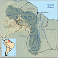 Essequiborivermap.png 1,000 × 1,000; 1.41 MB
-
 Ganges-Brahmaputra-Meghna basins.jpg 1,403 × 777; 1.09 MB
-
 Great Scarcies Basin OSM.svg 354 × 443; 3.23 MB
-
 Greattenasserimrivermap.png 1,000 × 1,476; 1.27 MB
-
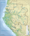 Hydrographie du Gabon.svg 815 × 965; 1.62 MB
-
 Krishna Basin.png 1,272 × 896; 1.63 MB
-
 Mekongbasin.jpg 2,886 × 3,306; 4.94 MB
-
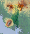 Mungo valley, Cameroon.svg 483 × 549; 752 KB
-
 Orinoco drainage basin map-es.svg 1,880 × 1,476; 1,003 KB
-
 Redriverasiamap.png 1,214 × 1,000; 2.25 MB
-
 Ubangirivermap.png 996 × 767; 1.16 MB
-
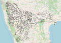
 Volta Basin OSM.svg 4,883 × 6,169; 94.11 MB


