Category:Rail transport maps of Pas-de-Calais
Jump to navigation
Jump to search
Media in category "Rail transport maps of Pas-de-Calais"
The following 8 files are in this category, out of 8 total.
-
 Railway map of France - 62 - 1880 - fr - small.svg 705 × 1,014; 7.64 MB
-
 Railway map of France - 62 - 1900 - fr - small.svg 705 × 1,014; 8.02 MB
-
 Railway map of France - 62 - 1909 - fr - small.svg 705 × 1,014; 8.15 MB
-
 Railway map of France - 62 - 1920 - fr - small.svg 705 × 1,014; 8.22 MB
-
 Railway map of France - 62 - 1930 - fr - small.svg 705 × 1,014; 8.22 MB
-
 Railway map of France - 62 - 1950 - fr - small.svg 705 × 1,014; 8.11 MB
-
 Railway map of France - 62 - 1980 - fr - small.svg 705 × 1,014; 8.05 MB
-
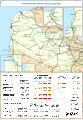
 Railway map of France - 62 - 2020 - fr - small.svg 705 × 1,014; 7.89 MB


