Category:Present climate (1980–2016)
Jump to navigation
Jump to search
Media in category "Present climate (1980–2016)"
The following 63 files are in this category, out of 63 total.
-
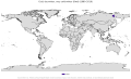
 Arid climate world map, classification UNEP (2023).png 3,600 × 1,465; 1.21 MB
-
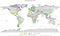
 Cf climate.png 2,581 × 1,118; 296 KB
-
 Cs climate.png 2,575 × 1,217; 538 KB
-
 Cw climate.png 2,568 × 1,152; 554 KB
-
 Df climate.png 2,576 × 1,174; 674 KB
-
 Ds climate.png 2,576 × 1,172; 558 KB
-
 Dw climate.png 2,503 × 1,134; 541 KB
-
 Humid and Arid climate world map, classification AI- UNEP, HI- Lobo et al (2023).png 3,600 × 1,465; 1.28 MB
-
 Humid climate world map, classification Lobo et al (2023).png 3,600 × 1,465; 1.22 MB
-
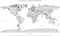
 Koppen-Geiger Map A present.svg 1,401 × 825; 75.4 MB
-
 Koppen-Geiger Map Af present.svg 1,401 × 850; 96.36 MB
-
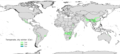
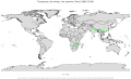
 Koppen-Geiger Map Am present.svg 1,401 × 850; 96.37 MB
-
 Koppen-Geiger Map Aw present.svg 1,401 × 850; 96.39 MB
-
 Koppen-Geiger Map B present.svg 1,401 × 850; 96.47 MB
-
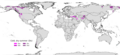
 Koppen-Geiger Map BSh present.svg 1,401 × 850; 96.38 MB
-
 Koppen-Geiger Map BSk present.svg 1,401 × 850; 96.41 MB
-
 Koppen-Geiger Map BWh present.svg 1,401 × 850; 96.37 MB
-
 Koppen-Geiger Map BWk present.svg 1,401 × 850; 96.38 MB
-
 Koppen-Geiger Map C present.svg 1,401 × 850; 96.46 MB
-
 Koppen-Geiger Map Central America present.svg 1,681 × 850; 2.63 MB
-
 Koppen-Geiger Map Cfa present.svg 1,401 × 850; 96.37 MB
-
 Koppen-Geiger Map Cfb present.svg 1,401 × 850; 96.38 MB
-
 Koppen-Geiger Map Cfc present.svg 1,401 × 850; 96.36 MB
-
 Koppen-Geiger Map Csa present.svg 1,401 × 850; 96.36 MB
-
 Koppen-Geiger Map Csb present.svg 1,401 × 850; 96.36 MB
-
 Koppen-Geiger Map Csc present.svg 1,401 × 850; 96.35 MB
-
 Koppen-Geiger Map Cwa present.svg 1,401 × 850; 96.38 MB
-
 Koppen-Geiger Map Cwb present.svg 1,401 × 850; 96.37 MB
-
 Koppen-Geiger Map Cwc present.svg 1,401 × 850; 96.35 MB
-
 Koppen-Geiger Map D present.svg 1,401 × 850; 96.51 MB
-
 Koppen-Geiger Map Dfa present.svg 1,401 × 850; 96.36 MB
-
 Koppen-Geiger Map Dfb present.svg 1,401 × 850; 96.38 MB
-
 Koppen-Geiger Map Dfc present.svg 1,401 × 850; 96.41 MB
-
 Koppen-Geiger Map Dfd present.svg 1,401 × 850; 96.36 MB
-
 Koppen-Geiger Map Dsa present.svg 1,401 × 850; 96.35 MB
-
 Koppen-Geiger Map Dsb present.svg 1,401 × 850; 96.36 MB
-
 Koppen-Geiger Map Dsc present.svg 1,401 × 850; 96.38 MB
-
 Koppen-Geiger Map Dsd present.svg 1,401 × 850; 96.35 MB
-
 Koppen-Geiger Map Dwa present.svg 1,401 × 850; 96.36 MB
-
 Koppen-Geiger Map Dwb present.svg 1,401 × 850; 96.36 MB
-
 Koppen-Geiger Map Dwc present.svg 1,401 × 850; 96.37 MB
-
 Koppen-Geiger Map Dwd present.svg 1,401 × 850; 96.35 MB
-
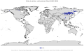
 Koppen-Geiger Map E present.svg 1,401 × 850; 96.42 MB
-
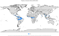
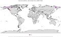
 Koppen-Geiger Map EF present.svg 1,401 × 850; 96.36 MB
-
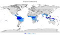
 Koppen-Geiger Map ET present.svg 1,401 × 850; 96.42 MB
-
 Koppen-Geiger Map Northern America present.svg 1,816 × 850; 12.96 MB
-
 Koppen-Geiger Map South America present.svg 1,294 × 850; 5.3 MB
-
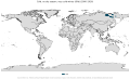
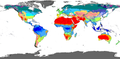
 Koppen-Geiger Map World present.svg 1,401 × 850; 96.74 MB
-
 Köppen-Geiger climate classification map (1980-2016) - more coastline details.png 16,093 × 7,986; 4.12 MB
-
 Köppen-Geiger Climate Classification Map (1980–2016) no borders.png 4,320 × 2,160; 271 KB
-
 Köppen-Geiger climate classification map Af-Am (1980-2016) - more coastline details.png 16,093 × 7,986; 3.39 MB
-
 Köppen-Geiger climate classification map Aw-As (1980-2016) - more coastline details.png 16,093 × 7,986; 3.39 MB
-
 Köppen-Geiger climate classification map BS (1980-2016) - more coastline details.png 16,093 × 7,986; 3.46 MB
-
 Köppen-Geiger climate classification map BW (1980-2016) - more coastline details.png 16,093 × 7,986; 3.39 MB
-
 Köppen-Geiger climate classification map Cf (1980-2016) - more coastline details.png 16,093 × 7,986; 3.41 MB
-
 Köppen-Geiger climate classification map Cs (1980-2016) - more coastline details.png 16,093 × 7,986; 3.34 MB
-
 Köppen-Geiger climate classification map Cw (1980-2016) - more coastline details.png 16,093 × 7,986; 3.37 MB
-
 Köppen-Geiger climate classification map Df (1980-2016) - more coastline details.png 16,093 × 7,986; 3.52 MB
-
 Köppen-Geiger climate classification map Ds (1980-2016) - more coastline details.png 16,093 × 7,986; 3.39 MB
-
 Köppen-Geiger climate classification map Dw (1980-2016) - more coastline details.png 16,093 × 7,986; 3.4 MB
-
 Köppen-Geiger climate classification map EF (1980-2016) - more coastline details.png 16,093 × 7,986; 3.34 MB
-
 Köppen-Geiger climate classification map ET (1980-2016) - more coastline details.png 16,093 × 7,986; 3.47 MB
-
 Köppen-Geiger Climate Classification Map.png 16,093 × 7,986; 4.91 MB


_-_more_coastline_details.png)
_no_borders.png)
_-_more_coastline_details.png)
_-_more_coastline_details.png)
_-_more_coastline_details.png)
_-_more_coastline_details.png)
_-_more_coastline_details.png)
_-_more_coastline_details.png)
_-_more_coastline_details.png)
_-_more_coastline_details.png)
_-_more_coastline_details.png)
_-_more_coastline_details.png)
_-_more_coastline_details.png)
_-_more_coastline_details.png)

.png)
.png)
.png)