Category:Pont sur la Raus (Sous la Rive N.N., Eschert)
Jump to navigation
Jump to search
| Object location | | View all coordinates using: OpenStreetMap |
|---|
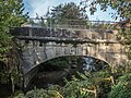
stone arch bridge over the river Raus in Eschert in the canton of Bern, Switzerland _%C3%BCber_die_Raus,_Eschert_BE_20231012-jag9889.jpg) | |||||
| Upload media | |||||
| Instance of | |||||
|---|---|---|---|---|---|
| Part of | |||||
| Location | Eschert, Bernese Jura administrative district, Bernese Jura administrative region, Bern, Switzerland | ||||
| Street address |
| ||||
| Crosses | |||||
| Heritage designation |
| ||||
| Inception |
| ||||
 | |||||
Media in category "Pont sur la Raus (Sous la Rive N.N., Eschert)"
This category contains only the following file.
-
 Steinbogenbrücke (2. Hälfte 19. Jh.) über die Raus, Eschert BE 20231012-jag9889.jpg 4,608 × 3,456; 12.02 MB