Category:Pierre couverte de la planche
Jump to navigation
Jump to search
| Object location | | View all coordinates using: OpenStreetMap |
|---|
|
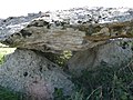
This building is inscrit au titre des monuments historiques de la France. It is indexed in the base Mérimée, a database of architectural heritage maintained by the French Ministry of Culture, under the reference PA00109000
|
dolmen in Broc, France  | |||||
| Upload media | |||||
| Instance of | |||||
|---|---|---|---|---|---|
| Location |
| ||||
| Street address |
| ||||
| Heritage designation |
| ||||
 | |||||
Media in category "Pierre couverte de la planche"
The following 4 files are in this category, out of 4 total.
-
 Broc - Dolmen 1.jpg 3,072 × 2,304; 3.47 MB
-
 Broc - Dolmen 2.jpg 3,072 × 2,304; 3.19 MB
-
 Broc - Dolmen 3.jpg 3,072 × 2,304; 3.32 MB
-
 Broc - Dolmen 4.jpg 2,816 × 2,112; 2.59 MB


