Category:Overhead power line crossings of rivers in Germany
Jump to navigation
Jump to search
Subcategories
This category has the following 23 subcategories, out of 23 total.
1
3
- 380-kV-Ems-Freileitungskreuzung (35 F)
B
E
- Elbekreuzung 1 (26 F)
- Elbekreuzung 2 (59 F)
K
- Köhlbrand-Freileitungskreuzung (23 F)
R
Media in category "Overhead power line crossings of rivers in Germany"
The following 67 files are in this category, out of 67 total.
-
 A2 elbbruecke hohenwarthe panorama.jpg 1,000 × 360; 115 KB
-
 Ausblick vom 366 km langen Neckartalradweg auf den Neckar bei Gemmrigheim - panoramio.jpg 3,264 × 2,448; 2.79 MB
-
 Beverungen - 2019-04-22 - HX-007 Buchenwaelder (06).jpg 5,000 × 3,333; 17.07 MB
-
 Der Rhein bei Wittlaer - geo.hlipp.de - 6044.jpg 640 × 480; 45 KB
-
 Der Rhein zwischen Zons und Monheim - geo.hlipp.de - 6047.jpg 640 × 480; 70 KB
-
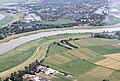
 Duisburg, Mündelheim, Rheinbogen, 2020-04 CN-01.jpg 4,287 × 2,771; 7.63 MB
-
 Düsseldorf-Bockum Rheinufer.jpg 2,000 × 1,125; 631 KB
-
 Elbe-Freileitungskreuzung Barby.jpg 4,000 × 3,000; 1.36 MB
-
 Elbebrücke Torgau.jpg 3,761 × 2,518; 8.06 MB
-
 Flug Westerstede nach Leer 2010 248.JPG 3,752 × 2,544; 7.38 MB
-
 Frankfurt Höchst castle and water front - Schloß und Uferpromenade - 01.jpg 4,838 × 3,205; 9.36 MB
-
 Frankfurt Höchst water front - Schloß und Uferpromenade - 03.jpg 7,768 × 3,767; 18.95 MB
-
 Frankfurt Höchst water front - Schloß und Uferpromenade - 04.jpg 4,928 × 3,264; 6.87 MB
-
 Frankfurt Höchst water front - Uferpromenade - 05.jpg 4,928 × 3,264; 8.24 MB
-
 Freileitungen Höchst (1).jpg 5,184 × 3,888; 4.73 MB
-
 Freileitungskreuzung bei Idar-Oberstein.png 1,961 × 1,414; 2.76 MB
-
 Freileitungskreuzung Daspig1.jpg 4,608 × 3,456; 7.18 MB
-
 Freileitungskreuzung Daspig2.jpg 4,608 × 3,456; 6.64 MB
-
 Freileitungskreuzung Elbe detail.jpg 3,000 × 4,000; 3.08 MB
-
 Freileitungskreuzung Magdeburg-Hohenwarte.jpg 4,608 × 3,456; 6.74 MB
-
 Freileitungskreuzung-Magdeburg.jpg 2,368 × 4,224; 3.28 MB
-
 Höchster Mainufer Batterie 2.jpg 2,560 × 1,574; 576 KB
-
 Kinzig mit Hochwasser bei Offenburg im Januar 2018 01.jpg 4,032 × 3,024; 6.05 MB
-
 Kraftwerk Walsum157119.jpg 3,456 × 2,592; 4.27 MB
-
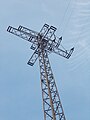 Kreuzmast1.jpg 3,456 × 4,608; 6.22 MB
-
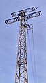 Kreuzmast2.jpg 2,368 × 4,224; 2.16 MB
-
 Kreuzmast3.jpg 4,224 × 2,368; 3 MB
-
 Laurent RDK.jpg 2,688 × 1,344; 517 KB
-
 Leer - Amdorfer Straße + Leda 02 ies.jpg 5,616 × 3,744; 21.65 MB
-
 Leer - Amdorfer Straße + Ledapegel 01 ies.jpg 5,616 × 3,744; 22.17 MB
-
 Leer - Amdorfer Straße - Leda + Ledapegel (Pausenanleger Pünte) 02 ies.jpg 5,616 × 3,744; 17.67 MB
-
 Leer Leerort + Westoverledingen - Leda + Gyas + Wagenborg Barge 2 + Triton 01 ies.jpg 5,616 × 3,743; 16.36 MB
-
 Lennetal FFSW PK 5151.jpg 5,921 × 3,953; 6.92 MB
-
 Lennetal FFSW PK 5179.jpg 2,461 × 3,686; 3.23 MB
-
 Luftbild Henne.jpg 827 × 531; 347 KB
-
 Meppen - DEK+Ems + Emsbrücke B402 (Amisia) 01 ies.jpg 5,616 × 3,744; 21.9 MB
-
 Meppen - DEK+Ems + Emsbrücke B402 (Amisia) 02 ies.jpg 5,616 × 3,744; 21.19 MB
-
 Meppen - DEK+Ems + Emsbrücke B402 (Amisia) 03 ies.jpg 5,616 × 3,744; 20.7 MB
-
 Meppen - DEK+Ems + Emsbrücke B402 (Amisia) 04 ies.jpg 5,616 × 3,744; 20.58 MB
-
 Meppen - DEK+Ems - Emsbrücke B402 (Amisia) 01 ies.jpg 5,616 × 3,744; 21.97 MB
-
 Meppen - DEK+Ems - Emsbrücke B402 (Amisia) 02 ies.jpg 5,616 × 3,744; 21.95 MB
-
 Meppen - DEK+Ems - Emsbrücke B402 (Amisia) 11 ies.jpg 5,616 × 3,743; 19.43 MB
-
 Meppen - DEK+Ems - Emsbrücke B402 (Amisia) 12 ies.jpg 5,616 × 3,743; 22.75 MB
-
 Meppen - DEK+Ems - Emsbrücke B402 (Amisia) 13 ies.jpg 5,616 × 3,744; 21.09 MB
-
 Meppen - DEK+Ems - Emsbrücke B402 (Amisia) 14 ies.jpg 5,616 × 3,744; 19.12 MB
-
 Meppen - DEK+Ems nördlich Emsbrücke B402 (Amisia) 01 ies.jpg 5,616 × 3,744; 20.72 MB
-
 Meppen - DEK+Ems südlich Emsbrücke B402 (Amisia) 02 ies.jpg 5,616 × 3,744; 19.52 MB
-
 Meppen - DEK+Ems südlich Emsbrücke B402 (Amisia) 03 ies.jpg 5,616 × 3,744; 21.67 MB
-
 Meppen - DEK+Ems südlich Emsbrücke B402 (Amisia) 05 ies.jpg 5,616 × 3,743; 20.84 MB
-
 Meppen - DEK+Ems südlich Emsbrücke B402 (Amisia) 06 ies.jpg 5,616 × 3,744; 19.95 MB
-
 Meppen, brug over de Ems 2008-08-31 10.36.JPG 3,072 × 2,304; 1.92 MB
-
 Murg Freileitungskreuzung 1.jpg 3,000 × 4,000; 3.61 MB
-
 Murg Freileitungskreuzung 2.jpg 3,456 × 4,608; 7.05 MB
-
 Mülheim adR - Styrumer Brücke 10 ies.jpg 5,616 × 3,744; 16.36 MB
-
 Papenburg+Weener - Deichverteidigungsstraße + Ems 01 ies.jpg 3,744 × 5,616; 16.24 MB
-
 Papenburg+Weener - Ems (Emsbrücke Papenburg) 01 ies.jpg 5,616 × 3,744; 20.91 MB
-
 Pleiße in Markkleeberg und querende Stromtrasse an der Mönchereibrücke Ende April 2018a.jpg 4,000 × 3,000; 4.13 MB
-
 Pleiße in Markkleeberg und querende Stromtrasse an der Mönchereibrücke Ende April 2018b.jpg 4,000 × 3,000; 4.17 MB
-
 Pleiße und Pleiße-Radweg in Markkleeberg im August 2003.jpg 1,600 × 1,200; 843 KB
-
 Plettenberg-Ohle Wasserkraftwerk FFSN-5533.jpg 4,928 × 3,280; 19.61 MB
-
 Rhein-Freileitungskreuzung Koblenz-Niederwerth-Urbar 2010.jpg 11,170 × 2,000; 3.58 MB
-
 Rheinufer beim Rheinstrandbad - geo.hlipp.de - 2836.jpg 640 × 480; 45 KB
-
 Rhine north of Koblenz, Germany. In the stream Niederwerth island. - panoramio.jpg 1,600 × 1,200; 876 KB
-
 Saarstahl Panorama.jpg 5,807 × 2,392; 12.38 MB
-
 Steel - panoramio (1).jpg 4,320 × 3,240; 4.18 MB
-
 Weener Halte + Papenburg - Ems 03 ies.jpg 3,744 × 5,616; 16.6 MB
-
 Weitspannfeld Mittelspannungsleitung Grossglattbach.jpg 3,648 × 2,736; 3.68 MB

.jpg)


.jpg)


_02_ies.jpg)


_01_ies.jpg)
_02_ies.jpg)
_03_ies.jpg)
_04_ies.jpg)
_01_ies.jpg)
_02_ies.jpg)
_11_ies.jpg)
_12_ies.jpg)
_13_ies.jpg)
_14_ies.jpg)
_01_ies.jpg)
_02_ies.jpg)
_03_ies.jpg)
_05_ies.jpg)
_06_ies.jpg)


_01_ies.jpg)


.jpg)

